Map of Lynnwood city
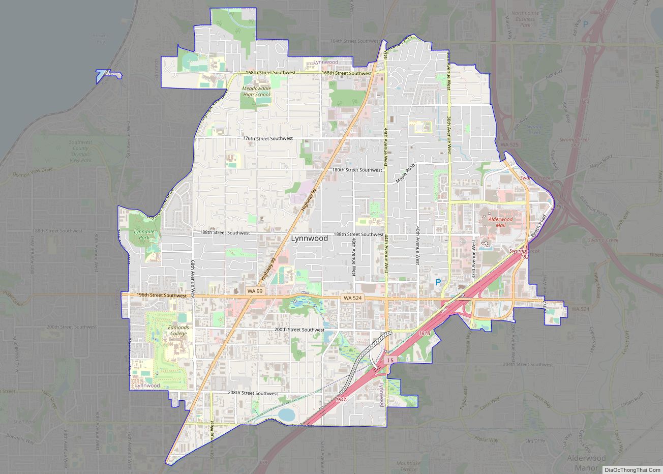
Lynnwood is a city in Snohomish County, Washington, United States. The city is part of the Seattle metropolitan area and is located 16 miles (26 km) north of Seattle and 13 miles (21 km) south of Everett, near the junction of Interstate 5 and Interstate 405. It is the fourth-largest city in Snohomish County, with a population ... Read more
Map of Lynnwood city
Map of Lynden city
Lynden is a city in Whatcom County, Washington, United States. It is located 15 miles (24 km) north of Bellingham and approximately 5 miles (8.0 km) south of Canada–US border. The city is located along the Nooksack River and State Route 539. The population of Lynden is about 14,259, according to the United States Census Bureau. Lynden ... Read more
Map of Lynden city
Map of Lyman town, Washington
Lyman town overview: Name: Lyman town LSAD Code: 43 LSAD Description: town (suffix) State: Washington County: Skagit County FIPS code: 5340770 Online Interactive Map Lyman online map. Source: Basemap layers from Google Map, Open Street Map (OSM), Arcgisonline, Wmflabs. Boundary Data from Database of Global Administrative Areas. Lyman location map. Where is Lyman town? Lyman ... Read more
Map of Lyman town, Washington
Map of Lower Elochoman CDP
Lower Elochoman is a census-designated place (CDP) in Wahkiakum County, Washington, United States. The population was 185 at the 2010 census. Lower Elochoman CDP overview: Name: Lower Elochoman CDP LSAD Code: 57 LSAD Description: CDP (suffix) State: Washington County: Wahkiakum County Elevation: 108 ft (33 m) Total Area: 185 Area code: 360 FIPS code: 5340570 Online Interactive ... Read more
Map of Lower Elochoman CDP
Map of Loon Lake CDP
Loon Lake is an unincorporated community and census-designated place in Stevens County, Washington, United States. Loon Lake is located on the northern shore of Loon Lake 5 miles (8.0 km) east of Springdale. The community is served by U.S. Route 395 and Washington State Route 292. Loon Lake has a post office with ZIP code 99148. ... Read more
Map of Loon Lake CDP
Map of Loomis CDP, Washington
Loomis is a census-designated place (CDP) in Okanogan County, Washington, United States. The population was 159 at the 2010 Census. Its area is 0.85 square miles (2.2 km), which is all land and no water. Loomis CDP overview: Name: Loomis CDP LSAD Code: 57 LSAD Description: CDP (suffix) State: Washington County: Okanogan County Elevation: 1,316 ft (401 m) ... Read more
Map of Loomis CDP, Washington
Map of Longview city, Washington
Longview is a city in Cowlitz County, Washington, United States. It is the principal city of the Longview, Washington Metropolitan Statistical Area, which encompasses all of Cowlitz County. Longview’s population was 37,818 at the time of the 2020 census, making it the largest city in Cowlitz County. The city is located in southwestern Washington, at ... Read more
Map of Longview city, Washington
Map of Longview Heights CDP
Longview Heights is a census-designated place (CDP) in Cowlitz County, Washington, United States. The population was 3,851 at the 2010 Census. The CDP is known locally as Columbia Heights. Longview Heights CDP overview: Name: Longview Heights CDP LSAD Code: 57 LSAD Description: CDP (suffix) State: Washington County: Cowlitz County Elevation: 886 ft (270 m) Total Area: 4.3 sq mi ... Read more
Map of Longview Heights CDP
Map of Longbranch CDP
Longbranch is an unincorporated community and census-designated places in Pierce County, Washington, United States. It is located on the Key Peninsula, along Filucy Bay between Pitt Passage and Balch Passage. Longbranch is primarily residential (like nearby Home and Lakebay) and includes a marina, church, and community centre. The community was named after Long Branch, New ... Read more
Map of Longbranch CDP
Map of Malden town, Washington
Malden town overview: Name: Malden town LSAD Code: 43 LSAD Description: town (suffix) State: Washington County: Whitman County FIPS code: 5342275 Online Interactive Map Malden online map. Source: Basemap layers from Google Map, Open Street Map (OSM), Arcgisonline, Wmflabs. Boundary Data from Database of Global Administrative Areas. Malden location map. Where is Malden town? Malden ... Read more
Map of Malden town, Washington
Map of Machias CDP, Washington
Machias is a census-designated place (CDP) in Snohomish County, Washington, United States. The population was 1,178 at the 2010 census. Machias was laid out in 1888, and named after Machias, Maine, the ancestral home of a first settler. A post office called Machias was established in 1892, and remained in operation until 1943. Machias CDP ... Read more
Map of Machias CDP, Washington
Map of Mabton city
Mabton is a city in Yakima County, Washington, United States. The population was 1,959 at the 2020 census. Incorporated during the first few years of the 20th century, it is located at the eastern edge of the Yakama Indian Reservation. Mabton city overview: Name: Mabton city LSAD Code: 25 LSAD Description: city (suffix) State: Washington ... Read more
Map of Mabton city