Map of River Road CDP, Washington
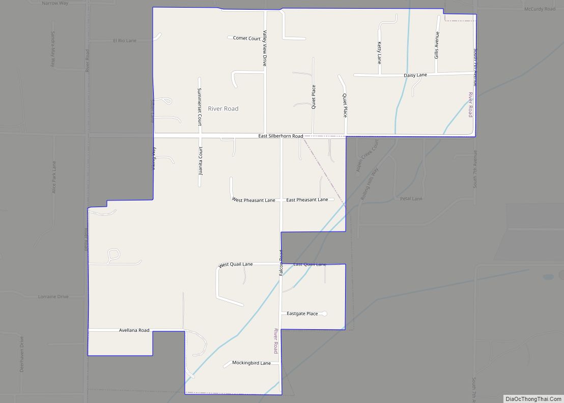
River Road is a census-designated place (CDP) in Clallam County, Washington, United States. The population was 454 at the 2010 census. It is a primarily residential area next to the city of Sequim. River Road CDP overview: Name: River Road CDP LSAD Code: 57 LSAD Description: CDP (suffix) State: Washington County: Clallam County Elevation: 315 ft ... Read more
Map of River Road CDP, Washington
Map of Ritzville city
Ritzville (/ˈrɪtsvɪl/) is a city in Adams County, Washington, United States. The population was 1,767 at the 2020 census. It is the county seat of Adams County. The city is part of the Othello, WA Micropolitan Area, which comprises all of Adams County, and is part of the larger Moses Lake-Othello, WA Combined Statistical Area. ... Read more
Map of Ritzville city
Map of Ridgefield city, Washington
Ridgefield is a city in northern Clark County, Washington, United States. The population was 10,319 at the time of the 2020 census, up from 4,763 in 2010, making it the fastest growing city in the state of Washington. Located within the Portland metropolitan area, Ridgefield is notable for the significant Native American history and connection ... Read more
Map of Ridgefield city, Washington
Map of Shelton city, Washington
Shelton is a city in and the county seat of Mason County, Washington, United States. Shelton is the westernmost city on Puget Sound. The population was 10,371 at the 2020 census. Shelton has a council–manager form of government and was the last city in Washington to use a mayor–commission form of government. Shelton city overview: ... Read more
Map of Shelton city, Washington
Map of Shadow Lake CDP
Shadow Lake is a census-designated place (CDP) in King County, Washington, United States. The population was 2,262 at the 2010 census. Shadow Lake CDP overview: Name: Shadow Lake CDP LSAD Code: 57 LSAD Description: CDP (suffix) State: Washington County: King County Elevation: 550 ft (170 m) Total Area: 5.33 sq mi (13.81 km²) Land Area: 5.19 sq mi (13.44 km²) Water Area: 0.14 sq mi ... Read more
Map of Shadow Lake CDP
Map of Rosedale CDP, Washington
Rosedale is a census-designated place (CDP) located in Pierce County, Washington. A post office called Rosedale was established in 1887, and remained in operation until 1918. The community was named for roses near the original town site. Rosedale CDP overview: Name: Rosedale CDP LSAD Code: 57 LSAD Description: CDP (suffix) State: Washington County: Pierce County ... Read more
Map of Rosedale CDP, Washington
Map of Sequim city
Sequim (/ˈskwɪm/ (listen) SKWIM) is a city in Clallam County, Washington, United States. It is located along the Dungeness River near the base of the Olympic Mountains. The 2020 census counted a population of 8,018, with an estimated population in 2021 of 8,241. Sequim lies within the rain shadow of the Olympic Mountains and receives, ... Read more
Map of Sequim city
Map of Rosburg CDP
Rosburg is a Census-designated place (CDP) in Wahkiakum County, Washington, United States. Rosburg is located on the Grays River near Washington State Route 4, 15 miles (24 km) northwest of Cathlamet. Rosburg has a post office with ZIP code 98643. The CDP includes the communities of Eden and Oneida. Christian Rosburg, the town’s first postmaster, named ... Read more
Map of Rosburg CDP
Map of Selah city
Selah is a city in Yakima County, Washington, United States. The population was 8,153 at the 2020 census. Selah city overview: Name: Selah city LSAD Code: 25 LSAD Description: city (suffix) State: Washington County: Yakima County Founded: 1871 Incorporated: March 17, 1919 Elevation: 1,119 ft (341 m) Total Area: 4.64 sq mi (12.01 km²) Land Area: 4.58 sq mi (11.86 km²) Water Area: ... Read more
Map of Selah city
Map of Rosalia town, Washington
Rosalia town overview: Name: Rosalia town LSAD Code: 43 LSAD Description: town (suffix) State: Washington County: Whitman County FIPS code: 5359775 Online Interactive Map Rosalia online map. Source: Basemap layers from Google Map, Open Street Map (OSM), Arcgisonline, Wmflabs. Boundary Data from Database of Global Administrative Areas. Rosalia location map. Where is Rosalia town? Rosalia ... Read more
Map of Rosalia town, Washington
Map of Sekiu CDP
Sekiu is an unincorporated community and census-designated place in Clallam County, Washington, United States. As of the 2010 census it had a population of 27. Overlooking the west side of Clallam Bay and the Strait of Juan de Fuca, it is twinned with the community of Clallam Bay, on the east side of the bay. ... Read more
Map of Sekiu CDP
Map of Sedro-Woolley city
Sedro-Woolley is a city in Skagit County, Washington, United States. It is part of the Mount Vernon–Anacortes, Washington Metropolitan Statistical Area and had a population of 12,421 at the 2020 census. The city is home to North Cascades National Park. Sedro-Woolley city overview: Name: Sedro-Woolley city LSAD Code: 25 LSAD Description: city (suffix) State: Washington ... Read more
Map of Sedro-Woolley city