Map of Kingston village, Wisconsin
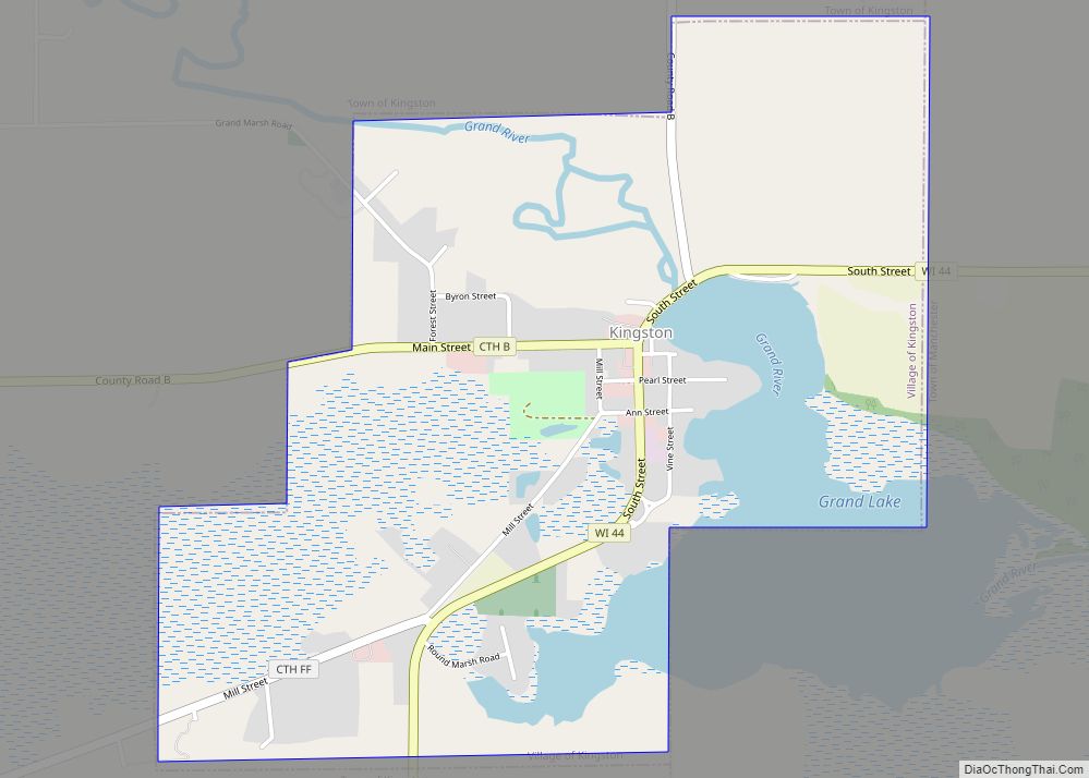
Kingston is a village in Green Lake County, Wisconsin, United States. The population was 326 at the 2010 census. The village is located within the Town of Kingston. The unincorporated community of Dalton, Wisconsin is near Kingston. The village is named for Kingston, Ontario. Kingston village overview: Name: Kingston village LSAD Code: 47 LSAD Description: ... Read more
Map of Kingston village, Wisconsin
Map of Kimberly village, Wisconsin
Kimberly is a village in Outagamie County, Wisconsin, United States. The population was 7,320 at the 2020 census. The village is east of Appleton. Kimberly village overview: Name: Kimberly village LSAD Code: 47 LSAD Description: village (suffix) State: Wisconsin County: Outagamie County Elevation: 732 ft (223 m) Total Area: 2.41 sq mi (6.25 km²) Land Area: 2.30 sq mi (5.95 km²) Water Area: ... Read more
Map of Kimberly village, Wisconsin
Map of Kieler CDP
Kieler is an unincorporated census-designated place in the Town of Jamestown in Grant County, Wisconsin. It is located about seven miles northeast of the Iowa–Wisconsin border and the city of Dubuque, Iowa, and about four miles southwest of Dickeyville, Wisconsin, along U.S. Highway 61 and U.S. Highway 151. As of the 2010 census, its population ... Read more
Map of Kieler CDP
Map of Kewaunee city
Kewaunee is a city in Kewaunee County, Wisconsin, United States. The population was 2,837 at the 2020 census. Located on the northwestern shore of Lake Michigan, the city is the county seat of Kewaunee County. Its Menominee name is Kewāneh, an archaic name for a species of duck. Kewaunee is part of the Green Bay ... Read more
Map of Kewaunee city
Map of Kewaskum village
Kewaskum is a village in Washington and Fond du Lac counties in Wisconsin, United States. The population was 4,004 at the 2010 census. All of this population resided in the Washington County portion of the village. The village is mostly surrounded by the Town of Kewaskum. Kewaskum village overview: Name: Kewaskum village LSAD Code: 47 ... Read more
Map of Kewaskum village
Map of Lac La Belle village
Lac La Belle is a village located mostly in Waukesha County in the U.S. state of Wisconsin. The population was 281 at the 2020 census. The village is located mostly within the town of Oconomowoc in Waukesha County. On March 28, 2002, the village annexed a portion of land in the town of Ixonia in ... Read more
Map of Lac La Belle village
Map of Lake Tomahawk CDP, Wisconsin
Lake Tomahawk is an unincorporated census-designated place located in the town of Lake Tomahawk, Oneida County, Wisconsin, United States. Lake Tomahawk is located on Wisconsin Highway 47 15 miles (24 km) northwest of Rhinelander. Lake Tomahawk has a post office with ZIP code 54539. As of the 2010 census, its population was 228. Lake Tomahawk CDP ... Read more
Map of Lake Tomahawk CDP, Wisconsin
Map of Lake Sherwood CDP, Wisconsin
Lake Sherwood is a census-designated place in the town of Rome, Adams County, Wisconsin, United States. Its population was 372 as of the 2010 census. Lake Sherwood CDP overview: Name: Lake Sherwood CDP LSAD Code: 57 LSAD Description: CDP (suffix) State: Wisconsin County: Adams County Elevation: 1,014 ft (309 m) Total Area: 1.404 sq mi (3.64 km²) Land Area: 1.054 sq mi ... Read more
Map of Lake Sherwood CDP, Wisconsin
Map of Lake Ripley CDP
Lake Ripley is a census-designated place (CDP), in the town of Oakland, Jefferson County, Wisconsin, United States. The population was 1,911 at the 2020 census. Lake Ripley CDP overview: Name: Lake Ripley CDP LSAD Code: 57 LSAD Description: CDP (suffix) State: Wisconsin County: Jefferson County Elevation: 853 ft (260 m) Total Area: 2.6 sq mi (6.7 km²) Land Area: 1.9 sq mi ... Read more
Map of Lake Ripley CDP
Map of Lake Nebagamon village
Lake Nebagamon is a village in Douglas County, Wisconsin, United States. The population was 1,069 at the 2010 census. Lake Nebagamon village overview: Name: Lake Nebagamon village LSAD Code: 47 LSAD Description: village (suffix) State: Wisconsin County: Douglas County Elevation: 1,152 ft (351 m) Total Area: 14.26 sq mi (36.94 km²) Land Area: 12.52 sq mi (32.43 km²) Water Area: 1.74 sq mi (4.51 km²) Total ... Read more
Map of Lake Nebagamon village
Map of Lake Mills city, Wisconsin
Lake Mills is a city in Jefferson County, Wisconsin, United States. The population was 6,211 at the 2020 census. The city is located partially within the Town of Lake Mills. Lake Mills city overview: Name: Lake Mills city LSAD Code: 25 LSAD Description: city (suffix) State: Wisconsin County: Jefferson County Elevation: 837 ft (255 m) Total Area: ... Read more
Map of Lake Mills city, Wisconsin
Map of Lake Lorraine CDP, Wisconsin
Lake Lorraine is a census-designated place in the town of Richmond, Walworth County, Wisconsin, United States. Its population was 338 as of the 2020 census. Lake Lorraine CDP overview: Name: Lake Lorraine CDP LSAD Code: 57 LSAD Description: CDP (suffix) State: Wisconsin County: Walworth County Elevation: 942 ft (287 m) Total Area: 1.250 sq mi (3.24 km²) Land Area: 1.117 sq mi ... Read more
Map of Lake Lorraine CDP, Wisconsin