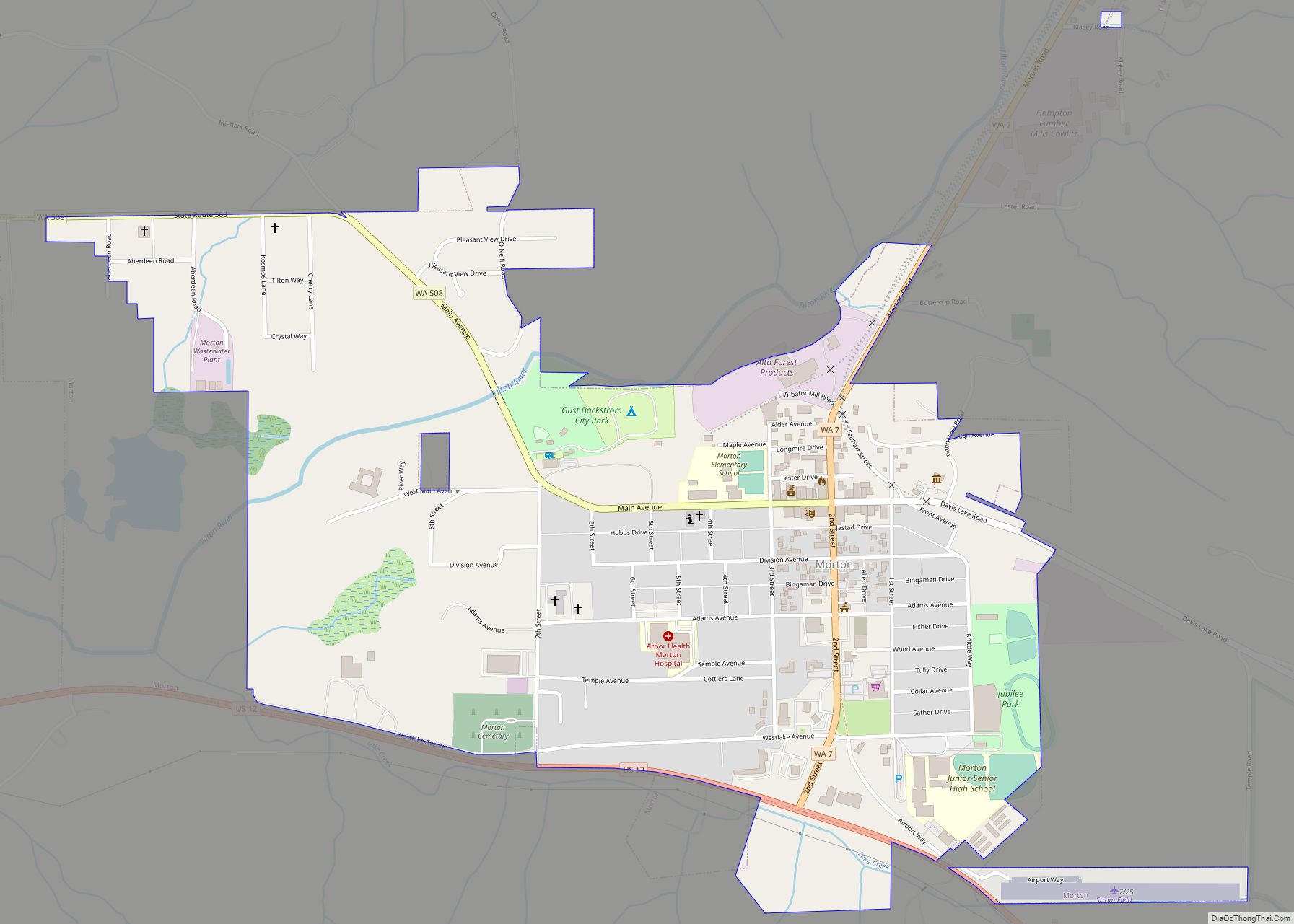
Nespelem Community is a census-designated place (CDP) in Okanogan County, Washington, United States. The population was 253 at the 2010 census. Nespelem Community CDP overview: Name: Nespelem Community CDP LSAD Code: 57 LSAD Description: CDP (suffix) State: Washington County: Okanogan County Total Area: 23.1 sq mi (59.9 km²) Land Area: 23.1 sq mi (59.8 km²) Water Area: 0.0 sq mi (0.0 km²) Total Population: ... Read more
Map of US Cities and Places
Neah Bay is a census-designated place (CDP) on the Makah Reservation in Clallam County, Washington, United States. The population was 865 at the 2010 census. It is across the Canada–US border from British Columbia. Originally called “Scarborough Harbour” in honor of Captain James Scarborough of the Hudson’s Bay Company, it was changed to Neah in ... Read more
Naselle is a census-designated place (CDP) in Pacific County, Washington, United States located about 23 miles (37 km) from the mouth of the Columbia River. The population was 419 at the 2010 census. The valley’s Naselle River flows west into nearby Willapa Bay and then into the Pacific Ocean. Close about the town lie the ... Read more
Napavine is a city in Lewis County, Washington, United States. The population was 1,766 at the 2020 census. Napavine city overview: Name: Napavine city LSAD Code: 25 LSAD Description: city (suffix) State: Washington County: Lewis County Incorporated: 1913 Elevation: 459 ft (140 m) Total Area: 2.90 sq mi (7.52 km²) Land Area: 2.89 sq mi (7.49 km²) Water Area: 0.01 sq mi (0.03 km²) Total Population: ... Read more
The Nisqually Reservation, also known as Nisqually Indian Reservation is a federally recognized Indian reservation in Thurston County, Washington, United States. The population was 668 at the 2020 census. Nisqually Indian Community CDP overview: Name: Nisqually Indian Community CDP LSAD Code: 57 LSAD Description: CDP (suffix) State: Washington County: Thurston County Total Area: 2.7 sq mi (7.1 km²) ... Read more
Northport town overview: Name: Northport town LSAD Code: 43 LSAD Description: town (suffix) State: Washington County: Stevens County FIPS code: 5350045 Online Interactive Map Northport online map. Source: Basemap layers from Google Map, Open Street Map (OSM), Arcgisonline, Wmflabs. Boundary Data from Database of Global Administrative Areas. Northport location map. Where is Northport town? Northport ... Read more
North Yelm is a census-designated place (CDP) in Thurston County, Washington, United States. The population was 3,140 at the 2020 census. The community borders Yelm and is situated near the intersection of Washington State Route 507 and SR 510. North Yelm CDP overview: Name: North Yelm CDP LSAD Code: 57 LSAD Description: CDP (suffix) State: ... Read more
Onalaska is an unincorporated community and census-designated place (CDP) in Lewis County, Washington, United States. As of the 2020 census it had a population of 657. Onalaska is located along Washington State Route 508. Onalaska CDP overview: Name: Onalaska CDP LSAD Code: 57 LSAD Description: CDP (suffix) State: Washington County: Lewis County Elevation: 515 ft (157 m) ... Read more
Ocean Park is a census-designated place (CDP) in Pacific County, Washington, United States. The population was 1,573 at the 2010 census. It is on the Long Beach Peninsula, north of Long Beach, Washington. Ocean Park CDP overview: Name: Ocean Park CDP LSAD Code: 57 LSAD Description: CDP (suffix) State: Washington County: Pacific County Elevation: 39 ft ... Read more
Packwood is an unincorporated community and census-designated place (CDP) located in easternmost Lewis County, Washington, in the United States. As of the 2020 census, the CDP had a population of 319, while the town and surrounding Packwood community (east of Cora Bridge) had a total population of 1,277. Packwood was originally established as Sulphur Springs. ... Read more
Port Angeles (/ˈændʒələs/ AN-jəl-əs) is a city and county seat of Clallam County, Washington, United States. With a population of 19,960 as of the 2020 census, it is the largest city in the county. The population was estimated at 20,134 in 2021. The city’s harbor was dubbed Puerto de Nuestra Señora de los Ángeles (Port ... Read more
Port Angeles East is a census-designated place (CDP) in Clallam County, Washington, United States. The population was 3,036 at the 2010 census. This unincorporated urban growth area bordering the city of Port Angeles is known by locals as the Gales Addition. Port Angeles East CDP overview: Name: Port Angeles East CDP LSAD Code: 57 LSAD ... Read more