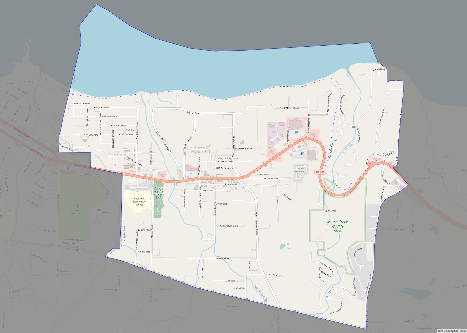
Rainier (/reɪˈnɪər/ ray-NEER) is a city in Thurston County, Washington, United States. Beginning as a train stop in the 1870s, Rainier was first settled in 1890 and would become known as a logging town. The city was officially incorporated in 1947. Rainier city overview: Name: Rainier city LSAD Code: 25 LSAD Description: city (suffix) State: ... Read more
Map of US Cities and Places
Rock Island is a city in Douglas County, Washington, United States. It is part of the Wenatchee–East Wenatchee Metropolitan Statistical Area. The population was 788 at the 2010 census. Rock Island city overview: Name: Rock Island city LSAD Code: 25 LSAD Description: city (suffix) State: Washington County: Douglas County Elevation: 643 ft (196 m) Total Area: 1.40 sq mi ... Read more
Roosevelt is an unincorporated community and census-designated place (CDP) in Klickitat County, Washington, United States. The population was 156 at the 2010 census, up from 79 at the 2000 census. The Roosevelt Regional Landfill, one of the largest landfills in the United States, is located at Roosevelt. The community was named after President Theodore Roosevelt. ... Read more
Ronald is an unincorporated community and census-designated place (CDP) in Kittitas County, Washington, United States. The population was 308 at the 2010 census. Ronald was named for Alexander Ronald, a former coal mine superintendent in the area. Ronald CDP overview: Name: Ronald CDP LSAD Code: 57 LSAD Description: CDP (suffix) State: Washington County: Kittitas County ... Read more
Raymond is a city in Pacific County, Washington, United States. The population was 2,882 at the 2010 census. The 2020 census showed the population of 3,081, an increase of 6.4%. The town’s economy has traditionally been based on logging and fishing, together with a limited amount of tourism. Raymond city overview: Name: Raymond city LSAD ... Read more
Roslyn is a city in Kittitas County, Washington, United States. The population was 893 at the 2010 census. Roslyn is located in the Cascade Mountains, about 80 miles east of Seattle. The town was founded in 1886 as a coal mining company town. During the 20th century, the town gradually transitioned away from coal, and ... Read more
Snoqualmie Pass is a census-designated place (CDP) in Kittitas County, Washington, United States. It includes the unincorporated community of Hyak. The population was 311 at the 2010 census. The CDP is named for the mountain pass that carries Interstate 90 across the Cascade Range, which itself is named for the Snoqualmie tribe, a Native American ... Read more
South Wenatchee is an unincorporated community and census-designated place (CDP) in Chelan County, Washington, United States. It is part of the Wenatchee–East Wenatchee Metropolitan Statistical Area. The population was 1,522 at the 2020 census. South Wenatchee CDP overview: Name: South Wenatchee CDP LSAD Code: 57 LSAD Description: CDP (suffix) State: Washington County: Chelan County Elevation: ... Read more
South Cle Elum town overview: Name: South Cle Elum town LSAD Code: 43 LSAD Description: town (suffix) State: Washington County: Kittitas County FIPS code: 5365765 Online Interactive Map South Cle Elum online map. Source: Basemap layers from Google Map, Open Street Map (OSM), Arcgisonline, Wmflabs. Boundary Data from Database of Global Administrative Areas. South Cle ... Read more
South Bend is a city in and the county seat of Pacific County, Washington, United States. The population was 1,637 as of the 2010 census. The town is widely-known for its oyster production and scenery. South Bend city overview: Name: South Bend city LSAD Code: 25 LSAD Description: city (suffix) State: Washington County: Pacific County ... Read more
Thorp (/θɔːrp/ THORP) is an unincorporated community and census-designated place (CDP) in Kittitas County, Washington, United States. In 2015, the population was 317 according to statistics compiled by Data USA. The town of Thorp is 100 miles (160 km) east of Seattle, 8 miles (13 km) northwest of Ellensburg, and 17 miles (27 km) southeast of Cle Elum. ... Read more
Tanglewilde (also Tanglewilde-Thompson Place) is a census-designated place (CDP) in Thurston County, Washington, United States, part of the Urban Growth Area of the city of Lacey. The community is surrounded by the city of Lacey and borders Mushroom Corner. The sections of Tanglewilde and Thompson Place are divided south and north, respectively, by Martin Way. ... Read more