Map of Winter Garden city
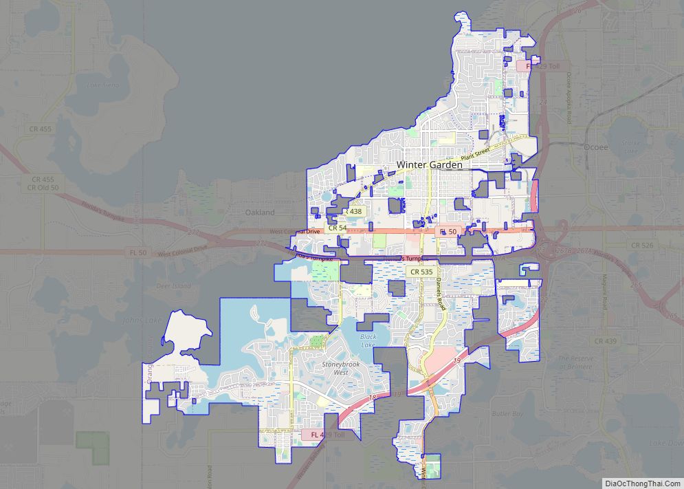
Winter Garden is a city 14 miles (23 km) west of Downtown Orlando in the western part of Orange County, Florida, United States. It is part of the Orlando–Kissimmee–Sanford, Florida Metropolitan Statistical Area. Its population was 46,964 as of 2020. Winter Garden city overview: Name: Winter Garden city LSAD Code: 25 LSAD Description: city (suffix) State: ... Read more
Map of Winter Garden city
Map of Winter Beach CDP
Winter Beach is a census-designated place (CDP) in Indian River County, Florida, United States. The population was 2,067 at the 2010 census, up from 965 at the 2000 census. It is part of the Sebastian–Vero Beach Metropolitan Statistical Area. Winter Beach CDP overview: Name: Winter Beach CDP LSAD Code: 57 LSAD Description: CDP (suffix) State: ... Read more
Map of Winter Beach CDP
Map of Wiscon CDP
Wiscon is an unincorporated community and census-designated place in Hernando County, Florida, United States. Its population was 681 as of the 2020 census. Florida State Road 50 passes through the community. Wiscon CDP overview: Name: Wiscon CDP LSAD Code: 57 LSAD Description: CDP (suffix) State: Florida County: Hernando County Elevation: 85 ft (26 m) Total Area: 0.84 sq mi ... Read more
Map of Wiscon CDP
Map of Winter Springs city
Winter Springs is a city in Seminole County, Florida, United States. The population was 38,342 at the 2020 census. It is part of the Orlando–Kissimmee–Sanford Metropolitan Statistical Area. The city was originally “North Orlando,” but because it was not adjacent to the city of Orlando, the confusion led to the new name “Winter Springs.” Winter ... Read more
Map of Winter Springs city
Map of Winter Park city, Florida
Winter Park is a city in Orange County, Florida, United States. The population was 29,795 according to the 2020 census. It is part of the Orlando–Kissimmee–Sanford, Florida Metropolitan Statistical Area. Winter Park was founded as a resort community by northern business magnates in the late 19th and early 20th centuries^ . Its main street, called ... Read more
Map of Winter Park city, Florida
Map of World Golf Village CDP
The World Golf Village (WGV) is a golf resort in St. Johns County, Florida, United States, located between Jacksonville and St. Augustine. It was created by the PGA Tour and showcases the World Golf Hall of Fame. In addition to the resort the World Golf Village features residential and commercial developments. There is also a ... Read more
Map of World Golf Village CDP
Map of Woodville CDP, Florida
Woodville is a census-designated place in Leon County, Florida, United States, just south of Tallahassee, Florida. The population was 2,978 at the 2010 census. It is part of the Tallahassee, Florida Metropolitan Statistical Area. The American Civil War Battle of Natural Bridge, in March 1865, occurred in what is now Woodville, at the Natural Bridge ... Read more
Map of Woodville CDP, Florida
Map of Woodlawn Beach CDP
Woodlawn Beach is a census-designated place (as of the 2010 Census) on Santa Rosa Sound in Santa Rosa County, Florida, United States surrounded by the older Midway CDP. It lies south of U.S. Highway 98 between Nantahala Beach Road (CR 191C) and Conover Cove, and includes the Woodlawn Beach Middle School, Woodlawn Beach Boat Ramp, ... Read more
Map of Woodlawn Beach CDP
Map of Yalaha CDP
Yalaha is an unincorporated area and census-designated place (CDP) in Lake County, Florida, United States. The population was 1,364 at the 2010 census, up from 1,175 at the 2000 census. It is part of the Orlando–Kissimmee Metropolitan Statistical Area. Yalaha CDP overview: Name: Yalaha CDP LSAD Code: 57 LSAD Description: CDP (suffix) State: Florida County: ... Read more
Map of Yalaha CDP
Map of Wright CDP, Florida
Wright is a census-designated place (CDP) in Okaloosa County, Florida, United States. The population was 23,127 at the 2010 United States Census. It is part of the Fort Walton Beach–Crestview–Destin Metropolitan Statistical Area. Wright CDP overview: Name: Wright CDP LSAD Code: 57 LSAD Description: CDP (suffix) State: Florida County: Okaloosa County Elevation: 43 ft (13 m) Total ... Read more
Map of Wright CDP, Florida
Map of Worthington Springs town
Worthington Springs is a spring and town in Union County, Florida, United States. The population was 181 at the 2010 census. According to the U.S. Census Bureau’s 2018 estimates, the town had a population of 380. Worthington Springs town overview: Name: Worthington Springs town LSAD Code: 43 LSAD Description: town (suffix) State: Florida County: Union ... Read more
Map of Worthington Springs town
Map of Yulee CDP
Yulee is a Census County Division (CCD) in Nassau County, Florida, United States. It is situated in northeastern Florida, directly south of the Florida/Georgia state line (St. Marys River), and 24 miles north of downtown Jacksonville, Florida. The CCD’s population is currently 36,742 as of a 2021 U.S. Census Bureau survey. Yulee is part of ... Read more
Map of Yulee CDP