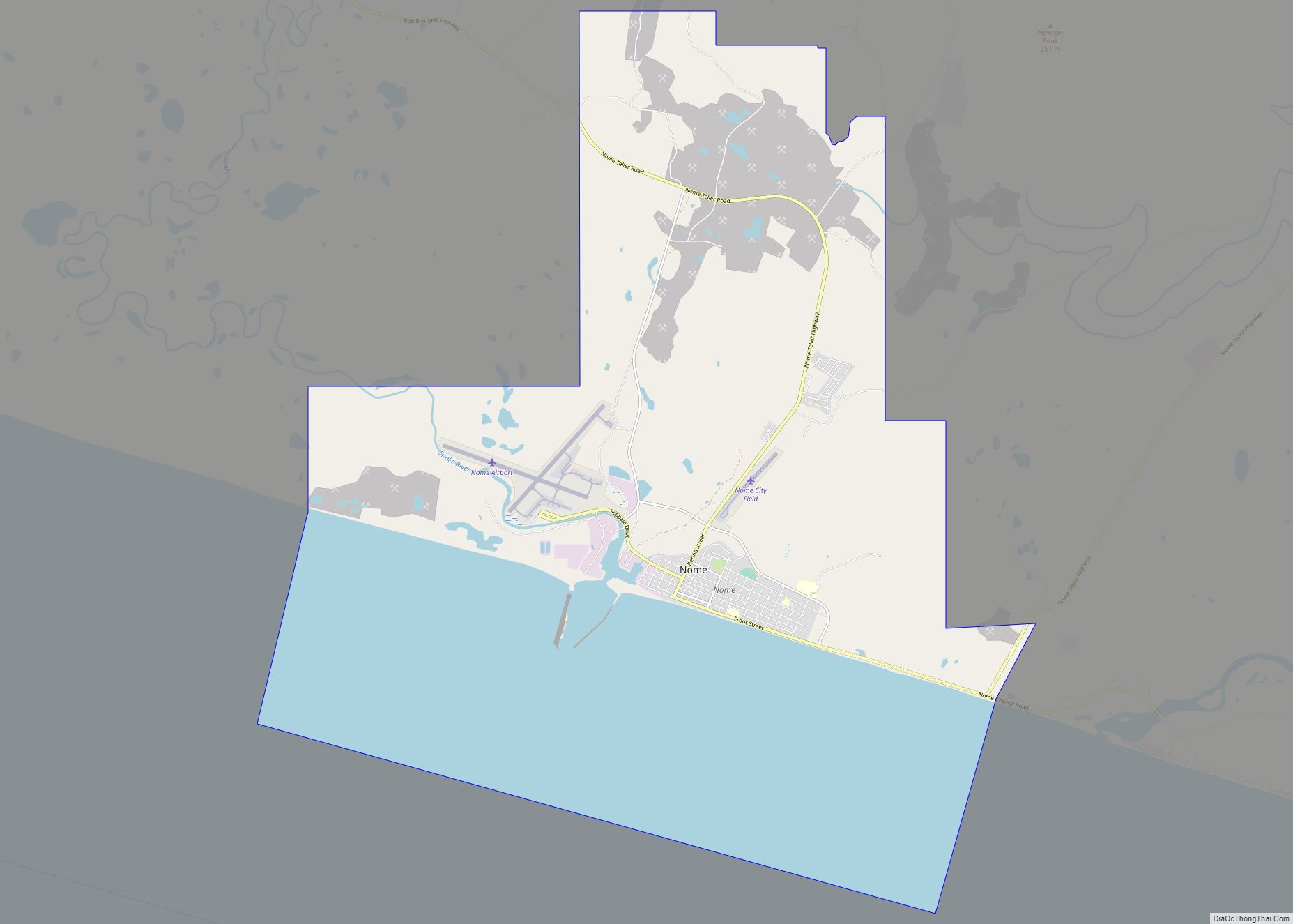
Map of Noatak CDP

Map of Noatak CDP

Noatak (Inupiaq: Nuataaq) is a census-designated place (CDP) in the Northwest Arctic Borough in the U.S. state of Alaska. The population was 570 at the 2020 census, up from 514 in 2010. It is served by Noatak Airport. Noatak CDP overview: Name: Noatak CDP LSAD Code: 57 LSAD Description: CDP (suffix) State: Alaska County: Northwest … Read more

Map of Ninilchik CDP

Map of Ninilchik CDP

Ninilchik (Russian: Нинильчик) (Dena’ina: Niqnalchint) is a census-designated place (CDP) in Kenai Peninsula Borough, Alaska, United States. At the 2010 census the population was 883, up from 772 in 2000. It is considered an Alaska Native village under the Alaska Native Claims Settlement Act. In the 1970s, villagers formed the Ninilchik Native Association Incorporated. Later … Read more

Map of North Pole city

Map of North Pole city

North Pole is a small city in the Fairbanks North Star Borough, Alaska, United States. Incorporated in 1953, it is part of the Fairbanks metropolitan statistical area. As of the 2020 census, the city had a population of 2,243, up from 2,117 in 2010. Despite its name, the city is about 1,700 miles (2,700 km) … Read more

Map of Noorvik city

Map of Noorvik city

Noorvik (Inupiaq: Nuurvik, meaning “A place to move to”) is an Iñupiat city in the Northwest Arctic Borough in the U.S. state of Alaska. As of the 2020 census, the population of the city was 694, up from 668 in 2010. Located in the NANA Region Corp, Noorvik has close ties with the largest city … Read more

Map of Nondalton city

Map of Nondalton city

Nondalton (Dena’ina: Nuvendaltun or Nundaltin) is a town on the west shore of Six Mile Lake in the Lake and Peninsula Borough, Alaska, United States. At the 2020 census, the population was 133, down from 164 in 2010. Nondalton city overview: Name: Nondalton city LSAD Code: 25 LSAD Description: city (suffix) State: Alaska County: Lake … Read more

Map of Northway CDP

Map of Northway CDP

Northway (K’ehtthiign in Upper Tanana Athabascan) is a census-designated place (CDP) in Southeast Fairbanks Census Area, Alaska, United States. Prior to the 2020 Census, the borders of the CDP got expanded to include Northway Junction and Northway Village. The population was 234 at the 2020 census, up from 71 in 2010. Northway CDP overview: Name: … Read more

Map of Northway Village CDP

Map of Northway Village CDP

Northway Village CDP overview: Name: Northway Village CDP LSAD Code: 57 LSAD Description: CDP (suffix) State: Alaska County: Southeast Fairbanks Census Area FIPS code: 0256260 Online Interactive Map Northway Village online map. Source: Basemap layers from Google Map, Open Street Map (OSM), Arcgisonline, Wmflabs. Boundary Data from Database of Global Administrative Areas. Northway Village location … Read more

Map of Northway Junction CDP

Map of Northway Junction CDP

Northway Junction CDP overview: Name: Northway Junction CDP LSAD Code: 57 LSAD Description: CDP (suffix) State: Alaska County: Southeast Fairbanks Census Area FIPS code: 0256250 Online Interactive Map Northway Junction online map. Source: Basemap layers from Google Map, Open Street Map (OSM), Arcgisonline, Wmflabs. Boundary Data from Database of Global Administrative Areas. Northway Junction location … Read more

Map of Nunam Iqua city

Map of Nunam Iqua city

Nunam Iqua, formerly called Sheldon Point, is a city in the Kusilvak Census Area in the U.S. state of Alaska. At the 2010 census the population was 187, up from 164 in 2000. Nunam Iqua is a Yupik name meaning “land’s end” (nuna = “land”; iquk = “end”). A man named Sheldon opened a fish … Read more

Map of Nulato city

Map of Nulato city

Nulato (/nuːˈlætoʊ/; Noolaaghe Doh /nuːlaːɣə tɔːχ/ “chum salmon fish camp” in Koyukon; Russian: Нулато) is a city in Yukon-Koyukuk Census Area, Alaska, United States. At the 2020 census, the population was 239. Nulato city overview: Name: Nulato city LSAD Code: 25 LSAD Description: city (suffix) State: Alaska County: Yukon-Koyukuk Census Area Incorporated: April 22, 1963 … Read more

Map of Nuiqsut city

Map of Nuiqsut city

Nuiqsut (Inupiaq: Nuiqsat, IPA: [nuiχsɐt]) is a city in North Slope Borough, Alaska, United States. The population was 512 at the 2020 Census and 92.5% Alaska Native. It is located in the midst of a vast quantity of oil reserves and the closest community to ConocoPhillips oil drilling project named Willow Project in the Alpine, Alaska … Read more

Map of Nunapitchuk city

Map of Nunapitchuk city

Nunapitchuk /nuːnəˈpɪtʃək/ (Central Yupik: Nunapicuar) is a city in Bethel Census Area, Alaska, United States. At the 2010 census the population was 496, up from 466 in 2000. Nunapitchuk city overview: Name: Nunapitchuk city LSAD Code: 25 LSAD Description: city (suffix) State: Alaska County: Bethel Census Area Incorporated: August 26, 1969 Elevation: 10 ft (3 m) Total … Read more