Map of Guthrie Center city
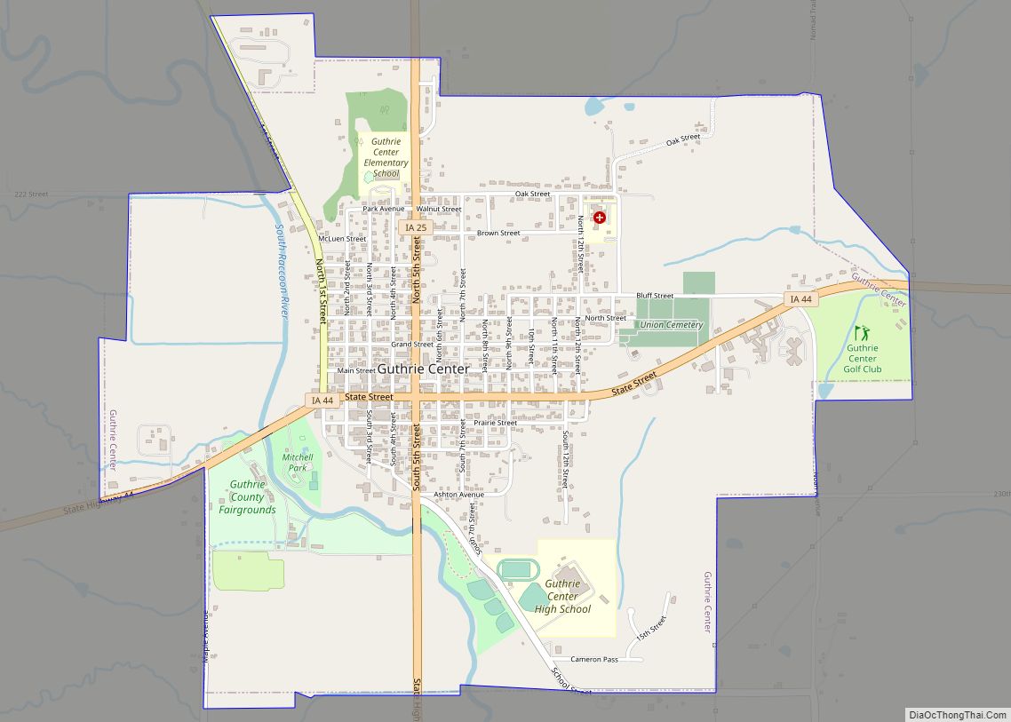
Guthrie Center is a city in Guthrie County, Iowa, United States, along the South Raccoon River. The population was 1,593 at the time of the 2020 census. It is the county seat of Guthrie County. Guthrie Center is part of the Des Moines–West Des Moines Metropolitan Statistical Area. Guthrie Center city overview: Name: Guthrie Center ... Read more
Map of Guthrie Center city
Map of Guernsey city, Iowa
Guernsey is a town in Poweshiek County, Iowa, United States. The population was 63 at the time of the 2020 census. Guernsey city overview: Name: Guernsey city LSAD Code: 25 LSAD Description: city (suffix) State: Iowa County: Poweshiek County Elevation: 823 ft (251 m) Total Area: 0.56 sq mi (1.46 km²) Land Area: 0.56 sq mi (1.46 km²) Water Area: 0.00 sq mi (0.00 km²) Total ... Read more
Map of Guernsey city, Iowa
Map of Hamilton city, Iowa
Hamilton is a city in Marion County, Iowa, United States. The population was 119 at the time of the 2020 census. Hamilton city overview: Name: Hamilton city LSAD Code: 25 LSAD Description: city (suffix) State: Iowa County: Marion County Elevation: 899 ft (274 m) Total Area: 0.51 sq mi (1.31 km²) Land Area: 0.51 sq mi (1.31 km²) Water Area: 0.00 sq mi (0.00 km²) Total ... Read more
Map of Hamilton city, Iowa
Map of Hamburg city, Iowa
Hamburg is a city in Fremont County, Iowa, United States, that is the most southwestern city in Iowa, hugging the borders of Missouri to the south and Nebraska to the west. It is situated between the Nishnabotna and Missouri rivers. The population was 890 at the time of the 2020 census. It derives its name ... Read more
Map of Hamburg city, Iowa
Map of Halbur city
Halbur is a city in Carroll County, Iowa, United States. The population was 243 at the time of the 2020 census. Halbur city overview: Name: Halbur city LSAD Code: 25 LSAD Description: city (suffix) State: Iowa County: Carroll County Elevation: 1,407 ft (429 m) Total Area: 0.18 sq mi (0.48 km²) Land Area: 0.18 sq mi (0.48 km²) Water Area: 0.00 sq mi (0.00 km²) Total ... Read more
Map of Halbur city
Map of Hanlontown city
Hanlontown is a city in Worth County, Iowa, United States. The population was 206 at the time of the 2020 census. It is part of the Mason City Micropolitan Statistical Area. Hanlontown city overview: Name: Hanlontown city LSAD Code: 25 LSAD Description: city (suffix) State: Iowa County: Worth County Founded: October 9, 1899 Incorporated: January ... Read more
Map of Hanlontown city
Map of Hancock city, Iowa
Hancock is a city in Pottawattamie County, Iowa, United States, along the West Nishnabotna River. The population was 200 at the time of the 2020 census. Hancock city overview: Name: Hancock city LSAD Code: 25 LSAD Description: city (suffix) State: Iowa County: Pottawattamie County Elevation: 1,112 ft (339 m) Total Area: 0.76 sq mi (1.97 km²) Land Area: 0.72 sq mi (1.87 km²) ... Read more
Map of Hancock city, Iowa
Map of Hampton city, Iowa
Hampton is a town in Franklin County, Iowa, United States. The population was 4,337 at the time of the 2020 census. It is the county seat of Franklin County. Hampton city overview: Name: Hampton city LSAD Code: 25 LSAD Description: city (suffix) State: Iowa County: Franklin County Elevation: 1,145 ft (349 m) Total Area: 4.42 sq mi (11.46 km²) Land ... Read more
Map of Hampton city, Iowa
Map of Hansell city
Hansell is a city in Franklin County, Iowa, United States. The population was 82 at the time of the 2020 census. Hansell city overview: Name: Hansell city LSAD Code: 25 LSAD Description: city (suffix) State: Iowa County: Franklin County Elevation: 1,037 ft (316 m) Total Area: 0.23 sq mi (0.58 km²) Land Area: 0.23 sq mi (0.58 km²) Water Area: 0.00 sq mi (0.00 km²) Total ... Read more
Map of Hansell city
Map of Hardy city, Iowa
Hardy is a city in Humboldt County, Iowa, United States. The population was 57 at the time of the 2020 census. Hardy city overview: Name: Hardy city LSAD Code: 25 LSAD Description: city (suffix) State: Iowa County: Humboldt County Elevation: 1,135 ft (346 m) Total Area: 0.45 sq mi (1.17 km²) Land Area: 0.45 sq mi (1.17 km²) Water Area: 0.00 sq mi (0.00 km²) Total ... Read more
Map of Hardy city, Iowa
Map of Harcourt city
Harcourt is a city in Webster County, Iowa, United States. The population was 264 at the time of the 2020 census. Harcourt city overview: Name: Harcourt city LSAD Code: 25 LSAD Description: city (suffix) State: Iowa County: Webster County Elevation: 1,175 ft (358 m) Total Area: 1.01 sq mi (2.62 km²) Land Area: 1.01 sq mi (2.62 km²) Water Area: 0.00 sq mi (0.00 km²) Total ... Read more
Map of Harcourt city
Map of Harpers Ferry city, Iowa
Harpers Ferry is a city in Taylor Township, Allamakee County, Iowa, United States. The population was 262 at the time of the 2020 census. Harpers Ferry city overview: Name: Harpers Ferry city LSAD Code: 25 LSAD Description: city (suffix) State: Iowa County: Allamakee County Elevation: 646 ft (197 m) Total Area: 0.66 sq mi (1.72 km²) Land Area: 0.65 sq mi (1.67 km²) ... Read more
Map of Harpers Ferry city, Iowa