Map of Ada CDP, Kansas
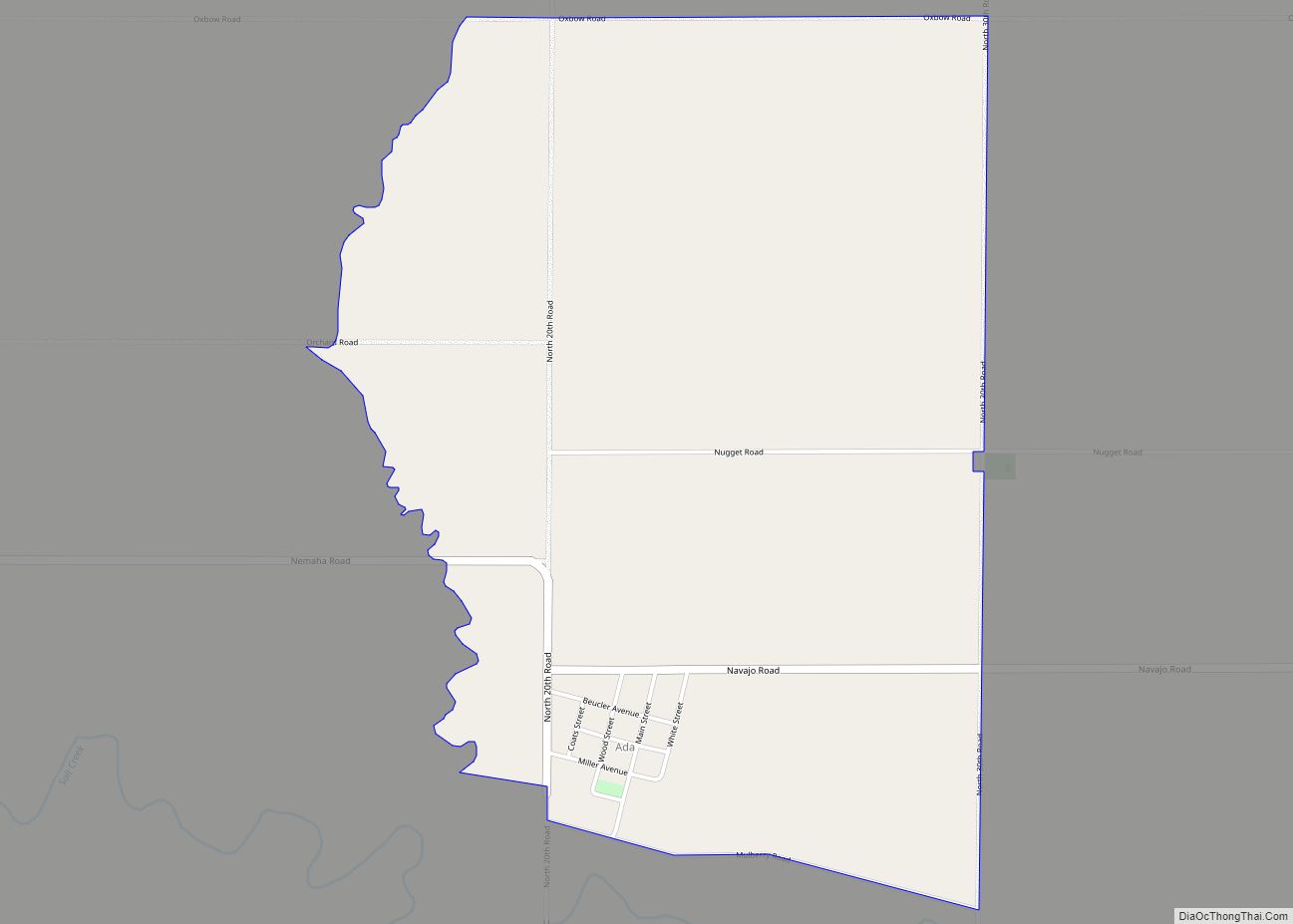
Ada is an unincorporated community in Ottawa County, Kansas, United States. As of the 2020 census, the population of the community and nearby areas was 86. It is located approximately 12 miles west of Minneapolis. Ada CDP overview: Name: Ada CDP LSAD Code: 57 LSAD Description: CDP (suffix) State: Kansas County: Ottawa County Elevation: 1,299 ft ... Read more
Map of Ada CDP, Kansas
Map of Abilene city, Kansas
Abilene (pronounced /ˈæbɪliːn/) is a city in, and the county seat of, Dickinson County, Kansas, United States. As of the 2020 census, the population of the city was 6,460. It is home of The Dwight D. Eisenhower Presidential Library and Museum and the Greyhound Hall of Fame. Abilene city overview: Name: Abilene city LSAD Code: ... Read more
Map of Abilene city, Kansas
Map of Albert city
Albert is a city in Barton County, Kansas, United States. As of the 2020 census, the population of the city was 132. Albert city overview: Name: Albert city LSAD Code: 25 LSAD Description: city (suffix) State: Kansas County: Barton County Founded: 1880s Incorporated: 1929 Elevation: 1,916 ft (584 m) Total Area: 0.23 sq mi (0.61 km²) Land Area: 0.23 sq mi (0.61 km²) ... Read more
Map of Albert city
Map of Agra city, Kansas
Agra is a city in Phillips County, Kansas, United States. As of the 2020 census, the population of the city was 208. Agra city overview: Name: Agra city LSAD Code: 25 LSAD Description: city (suffix) State: Kansas County: Phillips County Founded: 1888 Incorporated: 1904 Elevation: 1,850 ft (560 m) Total Area: 0.25 sq mi (0.65 km²) Land Area: 0.25 sq mi (0.65 km²) ... Read more
Map of Agra city, Kansas
Map of Agenda city
Agenda is a city in Republic County, Kansas, United States. As of the 2020 census, the population of the city was 47. Agenda city overview: Name: Agenda city LSAD Code: 25 LSAD Description: city (suffix) State: Kansas County: Republic County Founded: 1880s Incorporated: 1916 Elevation: 1,414 ft (431 m) Total Area: 0.17 sq mi (0.45 km²) Land Area: 0.17 sq mi (0.45 km²) ... Read more
Map of Agenda city
Map of Allen city, Kansas
Allen is a city in Lyon County, Kansas, United States. As of the 2020 census, the population of the city was 160. Allen city overview: Name: Allen city LSAD Code: 25 LSAD Description: city (suffix) State: Kansas County: Lyon County Founded: 1854 Incorporated: 1909 Elevation: 1,326 ft (404 m) Total Area: 0.28 sq mi (0.72 km²) Land Area: 0.28 sq mi (0.72 km²) ... Read more
Map of Allen city, Kansas
Map of Alexander city, Kansas
Alexander is a city in Rush County, Kansas, United States. As of the 2020 census, the population of the city was 54. Alexander city overview: Name: Alexander city LSAD Code: 25 LSAD Description: city (suffix) State: Kansas County: Rush County Founded: 1869 Incorporated: 1926 Elevation: 2,077 ft (633 m) Total Area: 0.26 sq mi (0.67 km²) Land Area: 0.26 sq mi (0.67 km²) ... Read more
Map of Alexander city, Kansas
Map of Alden city, Kansas
Alden is a city in Rice County, Kansas, United States. As of the 2020 census, the population of the city was 122. Alden city overview: Name: Alden city LSAD Code: 25 LSAD Description: city (suffix) State: Kansas County: Rice County Founded: 1872 Incorporated: 1916 Elevation: 1,680 ft (510 m) Total Area: 0.15 sq mi (0.40 km²) Land Area: 0.15 sq mi (0.40 km²) ... Read more
Map of Alden city, Kansas
Map of Alta Vista city, Kansas
Alta Vista is a city in Wabaunsee County, Kansas, United States. As of the 2020 census, the population of the city was 409. Alta Vista city overview: Name: Alta Vista city LSAD Code: 25 LSAD Description: city (suffix) State: Kansas County: Wabaunsee County Founded: 1887 Incorporated: 1905 Elevation: 1,457 ft (444 m) Total Area: 0.35 sq mi (0.90 km²) Land ... Read more
Map of Alta Vista city, Kansas
Map of Almena city, Kansas
Almena is a city in Norton County, Kansas, United States. As of the 2020 census, the population of the city was 363. Almena city overview: Name: Almena city LSAD Code: 25 LSAD Description: city (suffix) State: Kansas County: Norton County Incorporated: 1893 Elevation: 2,152 ft (656 m) Total Area: 0.60 sq mi (1.57 km²) Land Area: 0.60 sq mi (1.57 km²) Water Area: ... Read more
Map of Almena city, Kansas
Map of Alma city, Kansas
Alma is a city in and the county seat of Wabaunsee County, Kansas, United States. As of the 2020 census, the population of the city was 802. Alma city overview: Name: Alma city LSAD Code: 25 LSAD Description: city (suffix) State: Kansas County: Wabaunsee County Founded: 1867 Incorporated: 1869 Elevation: 1,109 ft (338 m) Total Area: 0.60 sq mi ... Read more
Map of Alma city, Kansas
Map of Altoona city, Kansas
Altoona is a city in Wilson County, Kansas, United States, along the Verdigris River. As of the 2020 census, the population of the city was 354. Altoona city overview: Name: Altoona city LSAD Code: 25 LSAD Description: city (suffix) State: Kansas County: Wilson County Founded: 1869 Incorporated: 1887 Elevation: 827 ft (252 m) Total Area: 0.54 sq mi (1.39 km²) ... Read more
Map of Altoona city, Kansas