Map of Baldwin City
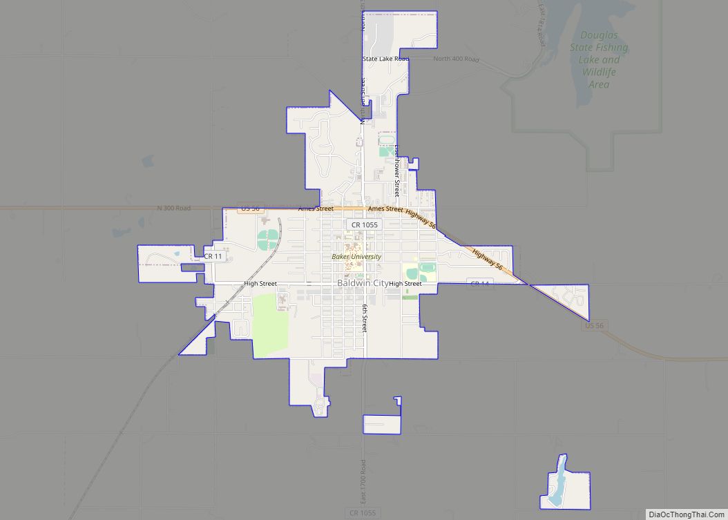
Baldwin City is a city in Douglas County, Kansas, United States, about 12 miles (19 km) south of Lawrence. As of the 2020 census, the population of the city was 4,826. The city is home to Baker University, the state’s oldest four-year university. Baldwin City city overview: Name: Baldwin City city LSAD Code: 25 LSAD Description: ... Read more
Map of Baldwin City
Map of Baileyville CDP, Kansas
Baileyville is an unincorporated community in western Nemaha County, Kansas, United States. As of the 2020 census, the population of the community and nearby areas was 182. It is located six miles west of Seneca on U.S. Route 36. Baileyville CDP overview: Name: Baileyville CDP LSAD Code: 57 LSAD Description: CDP (suffix) State: Kansas County: ... Read more
Map of Baileyville CDP, Kansas
Map of Basehor city
Basehor is a city in Leavenworth County, Kansas, United States which is included statistically in the Kansas City metropolitan area. As of the 2020 census, the population of the city was 6,896. However, incumbent mayor Dick Drennon has stated that Basehor’s population is around 7,500 people. As of April 2023, Basehor is the 2nd fastest-growing ... Read more
Map of Basehor city
Map of Bartlett city, Kansas
Bartlett is a city in Labette County, Kansas, United States. As of the 2020 census, the population of the city was 69. Bartlett city overview: Name: Bartlett city LSAD Code: 25 LSAD Description: city (suffix) State: Kansas County: Labette County Founded: 1880s Incorporated: 1906 Elevation: 892 ft (272 m) Total Area: 0.13 sq mi (0.34 km²) Land Area: 0.13 sq mi (0.34 km²) ... Read more
Map of Bartlett city, Kansas
Map of Barnes city
Barnes is a city in Washington County, Kansas, United States. As of the 2020 census, the population of the city was 165. Barnes city overview: Name: Barnes city LSAD Code: 25 LSAD Description: city (suffix) State: Kansas County: Washington County Founded: 1870 (Elm Grove) Incorporated: 1897 Elevation: 1,329 ft (405 m) Total Area: 0.18 sq mi (0.46 km²) Land Area: ... Read more
Map of Barnes city
Map of Bazine city
Bazine is a city in Ness County, Kansas, United States. As of the 2020 census, the population of the city was 282. Bazine city overview: Name: Bazine city LSAD Code: 25 LSAD Description: city (suffix) State: Kansas County: Ness County Founded: 1870s Incorporated: 1924 Elevation: 2,129 ft (649 m) Total Area: 0.45 sq mi (1.16 km²) Land Area: 0.45 sq mi (1.16 km²) ... Read more
Map of Bazine city
Map of Baxter Springs city
Baxter Springs is a city in Cherokee County, Kansas, United States, and located along Spring River. As of the 2020 census, the population of the city was 3,888. Baxter Springs city overview: Name: Baxter Springs city LSAD Code: 25 LSAD Description: city (suffix) State: Kansas County: Cherokee County Founded: 1858 Incorporated: 1868 Elevation: 843 ft (257 m) ... Read more
Map of Baxter Springs city
Map of Bassett city, Kansas
Bassett is a city in Allen County, Kansas, United States. It is situated along the Neosho River. As of the 2020 census, the population of the city was 20. Bassett city overview: Name: Bassett city LSAD Code: 25 LSAD Description: city (suffix) State: Kansas County: Allen County Founded: 1903 Incorporated: 1903 Elevation: 974 ft (297 m) Total ... Read more
Map of Bassett city, Kansas
Map of Belle Plaine city, Kansas
Belle Plaine is a city in Sumner County, Kansas, United States. As of the 2020 census, the population of the city was 1,467. Belle Plaine city overview: Name: Belle Plaine city LSAD Code: 25 LSAD Description: city (suffix) State: Kansas County: Sumner County Founded: 1871 Incorporated: 1884 Elevation: 1,224 ft (373 m) Total Area: 0.83 sq mi (2.15 km²) Land ... Read more
Map of Belle Plaine city, Kansas
Map of Bel Aire city
Bel Aire is a city in Sedgwick County, Kansas, United States, and a suburb of Wichita. As of the 2020 census, the population of the city was 8,262. Bel Aire city overview: Name: Bel Aire city LSAD Code: 25 LSAD Description: city (suffix) State: Kansas County: Sedgwick County Founded: 1955 Incorporated: 1980 Elevation: 1,394 ft (425 m) ... Read more
Map of Bel Aire city
Map of Beattie city
Beattie is a city in Marshall County, Kansas, United States. As of the 2020 census, the population of the city was 197. The city has been called “The Milo Capital of the World” and hosts the annual “Beattie Milo Festival”. Beattie city overview: Name: Beattie city LSAD Code: 25 LSAD Description: city (suffix) State: Kansas ... Read more
Map of Beattie city
Map of Belpre city, Kansas
Belpre is a city in Edwards County, Kansas, United States. As of the 2020 census, the population of the city was 97. Belpre city overview: Name: Belpre city LSAD Code: 25 LSAD Description: city (suffix) State: Kansas County: Edwards County Founded: 1879 Incorporated: 1906 Elevation: 2,097 ft (639 m) Total Area: 0.41 sq mi (1.06 km²) Land Area: 0.41 sq mi (1.06 km²) ... Read more
Map of Belpre city, Kansas