Map of Moundridge city
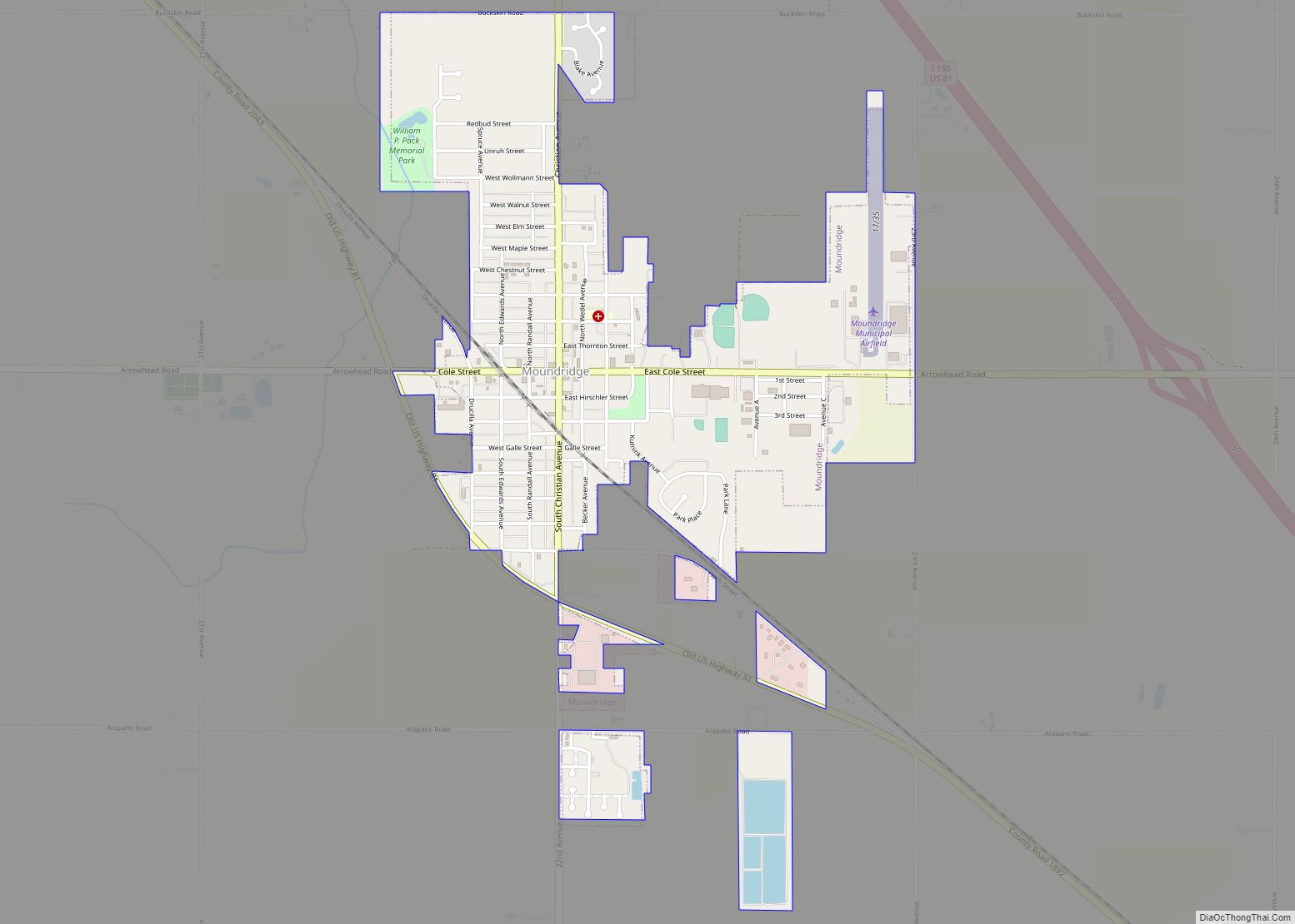
Moundridge is a city in McPherson County, Kansas, United States. As of the 2020 census, the population of the city was 1,974. Manufacturing facilities for Grasshopper (lawn mowers) and Bradbury Group (roll forming equipment) are located in Moundridge. Moundridge city overview: Name: Moundridge city LSAD Code: 25 LSAD Description: city (suffix) State: Kansas County: McPherson ... Read more
Map of Moundridge city
Map of Mound Valley city
Mound Valley is a city in Labette County, Kansas, United States. As of the 2020 census, the population of the city was 348. Mound Valley city overview: Name: Mound Valley city LSAD Code: 25 LSAD Description: city (suffix) State: Kansas County: Labette County Founded: 1869 Incorporated: 1871 Elevation: 833 ft (254 m) Total Area: 0.64 sq mi (1.66 km²) Land ... Read more
Map of Mound Valley city
Map of Mound City, Kansas
Mound City is a city in and the county seat of Linn County, Kansas, United States. As of the 2020 census, the population of the city was 647. Mound City city overview: Name: Mound City city LSAD Code: 25 LSAD Description: city (suffix) State: Kansas County: Linn County Founded: 1855 Incorporated: 1871 Elevation: 879 ft (268 m) ... Read more
Map of Mound City, Kansas
Map of Mullinville city
Mullinville is a city in Kiowa County, Kansas, United States. As of the 2020 census, the population of the city was 197. Mullinville city overview: Name: Mullinville city LSAD Code: 25 LSAD Description: city (suffix) State: Kansas County: Kiowa County Founded: 1880s Incorporated: 1911 Elevation: 2,323 ft (708 m) Total Area: 0.64 sq mi (1.66 km²) Land Area: 0.64 sq mi (1.66 km²) ... Read more
Map of Mullinville city
Map of Mulberry city, Kansas
Mulberry is a city in Crawford County, Kansas, United States. As of the 2020 census, the population of the city was 409. Mulberry city overview: Name: Mulberry city LSAD Code: 25 LSAD Description: city (suffix) State: Kansas County: Crawford County Founded: 1875 Incorporated: 1902 Elevation: 909 ft (277 m) Total Area: 0.47 sq mi (1.22 km²) Land Area: 0.47 sq mi (1.22 km²) ... Read more
Map of Mulberry city, Kansas
Map of Mount Hope city, Kansas
Mount Hope is a city in Sedgwick County, Kansas, United States. As of the 2020 census, the population of the city was 806. Mount Hope city overview: Name: Mount Hope city LSAD Code: 25 LSAD Description: city (suffix) State: Kansas County: Sedgwick County Founded: 1874 Incorporated: 1887 Elevation: 1,440 ft (440 m) Total Area: 1.49 sq mi (3.86 km²) Land ... Read more
Map of Mount Hope city, Kansas
Map of Munjor CDP
Munjor is an unincorporated community in Wheatland Township, Ellis County, Kansas, United States. As of the 2020 census, the population of the community and nearby areas was 232. Munjor CDP overview: Name: Munjor CDP LSAD Code: 57 LSAD Description: CDP (suffix) State: Kansas County: Ellis County Founded: 1876 Elevation: 1,942 ft (592 m) Total Area: 2.31 sq mi (5.97 km²) ... Read more
Map of Munjor CDP
Map of Munden city
Munden is a city in Republic County, Kansas, United States. As of the 2020 census, the population of the city was 96. Munden city overview: Name: Munden city LSAD Code: 25 LSAD Description: city (suffix) State: Kansas County: Republic County Founded: 1887 Incorporated: 1903 Elevation: 1,634 ft (498 m) Total Area: 0.19 sq mi (0.48 km²) Land Area: 0.19 sq mi (0.48 km²) ... Read more
Map of Munden city
Map of Mulvane city
Mulvane is a city in Sedgwick and Sumner counties in the U.S. state of Kansas. As of the 2020 census, the population of the city was 6,286. Mulvane city overview: Name: Mulvane city LSAD Code: 25 LSAD Description: city (suffix) State: Kansas County: Sedgwick County, Sumner County Founded: 1870s Incorporated: 1883 Elevation: 1,237 ft (377 m) Total ... Read more
Map of Mulvane city
Map of Nashville city, Kansas
Nashville is a city in Kingman County, Kansas, United States. As of the 2020 census, the population of the city was 54. Nashville city overview: Name: Nashville city LSAD Code: 25 LSAD Description: city (suffix) State: Kansas County: Kingman County Founded: 1888 Incorporated: 1913 Elevation: 1,752 ft (534 m) Total Area: 0.20 sq mi (0.53 km²) Land Area: 0.20 sq mi (0.53 km²) ... Read more
Map of Nashville city, Kansas
Map of Narka city
Narka is a city in Republic County, Kansas, United States. As of the 2020 census, the population of the city was 81. Narka city overview: Name: Narka city LSAD Code: 25 LSAD Description: city (suffix) State: Kansas County: Republic County Founded: 1887 Incorporated: 1899 Elevation: 1,585 ft (483 m) Total Area: 0.16 sq mi (0.41 km²) Land Area: 0.16 sq mi (0.41 km²) ... Read more
Map of Narka city
Map of Muscotah city
Muscotah is a city in Atchison County, Kansas, United States. As of the 2020 census, the population of the city was 155. Muscotah was named for the Kickapoo Native American word for “prairie” Muscotah city overview: Name: Muscotah city LSAD Code: 25 LSAD Description: city (suffix) State: Kansas County: Atchison County Elevation: 1,014 ft (309 m) Total ... Read more
Map of Muscotah city