Map of Tyro city, Kansas
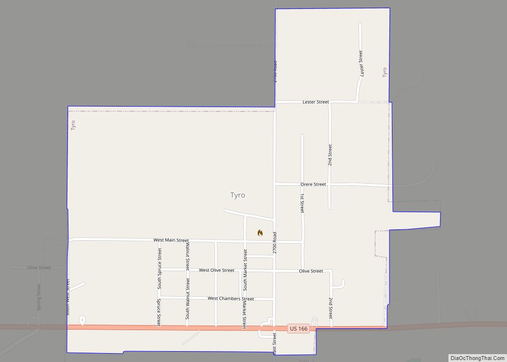
Tyro is a city in Montgomery County, Kansas, United States. As of the 2020 census, the population of the city was 177. Tyro city overview: Name: Tyro city LSAD Code: 25 LSAD Description: city (suffix) State: Kansas County: Montgomery County Founded: 1886 Incorporated: 1906 Elevation: 889 ft (271 m) Total Area: 0.52 sq mi (1.35 km²) Land Area: 0.52 sq mi (1.34 km²) ... Read more
Map of Tyro city, Kansas
Map of Turon city
Turon is a city in Reno County, Kansas, United States. As of the 2020 census, the population of the city was 309. Turon city overview: Name: Turon city LSAD Code: 25 LSAD Description: city (suffix) State: Kansas County: Reno County Founded: 1886 Incorporated: 1905 Elevation: 1,762 ft (537 m) Total Area: 0.45 sq mi (1.15 km²) Land Area: 0.45 sq mi (1.15 km²) ... Read more
Map of Turon city
Map of Troy city, Kansas
Troy is a city in and the county seat of Doniphan County, Kansas, United States. As of the 2020 census, the population of the city was 964. Troy city overview: Name: Troy city LSAD Code: 25 LSAD Description: city (suffix) State: Kansas County: Doniphan County Founded: 1855 Incorporated: 1860 Elevation: 1,099 ft (335 m) Total Area: 0.98 sq mi ... Read more
Map of Troy city, Kansas
Map of Uniontown city, Kansas
Uniontown is a city in Bourbon County, Kansas, United States. As of the 2020 census, the population of the city was 293. Uniontown city overview: Name: Uniontown city LSAD Code: 25 LSAD Description: city (suffix) State: Kansas County: Bourbon County Incorporated: 1895 Elevation: 892 ft (272 m) Total Area: 0.21 sq mi (0.55 km²) Land Area: 0.21 sq mi (0.55 km²) Water Area: ... Read more
Map of Uniontown city, Kansas
Map of Ulysses city, Kansas
Ulysses (pronounced /juːˈlɪsɪs/) is a city in and the county seat of Grant County, Kansas, United States. It is named after Ulysses S. Grant, the 18th President of the United States. As of the 2020 census, the population of the city was 5,788. Ulysses city overview: Name: Ulysses city LSAD Code: 25 LSAD Description: city ... Read more
Map of Ulysses city, Kansas
Map of Udall city
Udall is a city in Cowley County, Kansas, United States. As of the 2020 census, the population of the city was 661. Udall city overview: Name: Udall city LSAD Code: 25 LSAD Description: city (suffix) State: Kansas County: Cowley County Founded: 1870s Incorporated: 1881 Elevation: 1,273 ft (388 m) Total Area: 0.55 sq mi (1.41 km²) Land Area: 0.55 sq mi (1.41 km²) ... Read more
Map of Udall city
Map of Valley Falls city, Kansas
Valley Falls is a city in Jefferson County, Kansas, United States. As of the 2020 census, the population of the city was 1,092. Valley Falls city overview: Name: Valley Falls city LSAD Code: 25 LSAD Description: city (suffix) State: Kansas County: Jefferson County Founded: 1854 Incorporated: 1869 Elevation: 942 ft (287 m) Total Area: 0.71 sq mi (1.84 km²) Land ... Read more
Map of Valley Falls city, Kansas
Map of Valley Center city, Kansas
Valley Center is a city in Sedgwick County, Kansas, United States, and a suburb of Wichita. As of the 2020 census, the population of the city was 7,340. Valley Center city overview: Name: Valley Center city LSAD Code: 25 LSAD Description: city (suffix) State: Kansas County: Sedgwick County Founded: 1870s Incorporated: 1885 Elevation: 1,345 ft (410 m) ... Read more
Map of Valley Center city, Kansas
Map of Utica city, Kansas
Utica is a city in Ness County, Kansas, United States. As of the 2020 census, the population of the city was 99. Utica city overview: Name: Utica city LSAD Code: 25 LSAD Description: city (suffix) State: Kansas County: Ness County Founded: 1870s Incorporated: 1911 Elevation: 2,622 ft (799 m) Total Area: 0.24 sq mi (0.63 km²) Land Area: 0.24 sq mi (0.63 km²) ... Read more
Map of Utica city, Kansas
Map of Vermillion city, Kansas
Vermillion is a city in Marshall County, Kansas, United States. As of the 2020 census, the population of the city was 76. Vermillion city overview: Name: Vermillion city LSAD Code: 25 LSAD Description: city (suffix) State: Kansas County: Marshall County Founded: 1869 Incorporated: 1899 Elevation: 1,234 ft (376 m) Total Area: 0.22 sq mi (0.56 km²) Land Area: 0.21 sq mi (0.54 km²) ... Read more
Map of Vermillion city, Kansas
Map of Vassar CDP, Kansas
Vassar is an unincorporated community in Osage County, Kansas, United States. As of the 2020 census, the population of the community and nearby areas was 584. It is located 4 miles (6.4 km) northeast of Lyndon, also about half a mile south of Pomona Lake. Vassar CDP overview: Name: Vassar CDP LSAD Code: 57 LSAD Description: ... Read more
Map of Vassar CDP, Kansas
Map of Victoria city, Kansas
Victoria is a city in Ellis County, Kansas, United States. As of the 2020 census, the population of the city was 1,129. Victoria city overview: Name: Victoria city LSAD Code: 25 LSAD Description: city (suffix) State: Kansas County: Ellis County Founded: 1873 Incorporated: 1913 Elevation: 1,926 ft (587 m) Total Area: 0.60 sq mi (1.55 km²) Land Area: 0.60 sq mi (1.55 km²) ... Read more
Map of Victoria city, Kansas