Map of Viola city, Kansas
Viola is a city in Sedgwick County, Kansas, United States. As of the 2020 census, the population of the city was 115. Viola city overview: Name: Viola city LSAD Code: 25 LSAD Description: city (suffix) State: Kansas County: Sedgwick County Founded: 1870s Incorporated: 1909 Elevation: 1,339 ft (408 m) Total Area: 0.16 sq mi (0.43 km²) Land Area: 0.16 sq mi (0.43 km²) ... Read more
Map of Viola city, Kansas
Map of Vining city, Kansas
Vining is a city in Clay and Washington counties in Kansas, United States. As of the 2020 census, the population of the city was 43. Vining city overview: Name: Vining city LSAD Code: 25 LSAD Description: city (suffix) State: Kansas County: Clay County, Washington County Incorporated: 1885 Elevation: 1,270 ft (390 m) Total Area: 0.21 sq mi (0.55 km²) Land ... Read more
Map of Vining city, Kansas
Map of Virgil city, Kansas
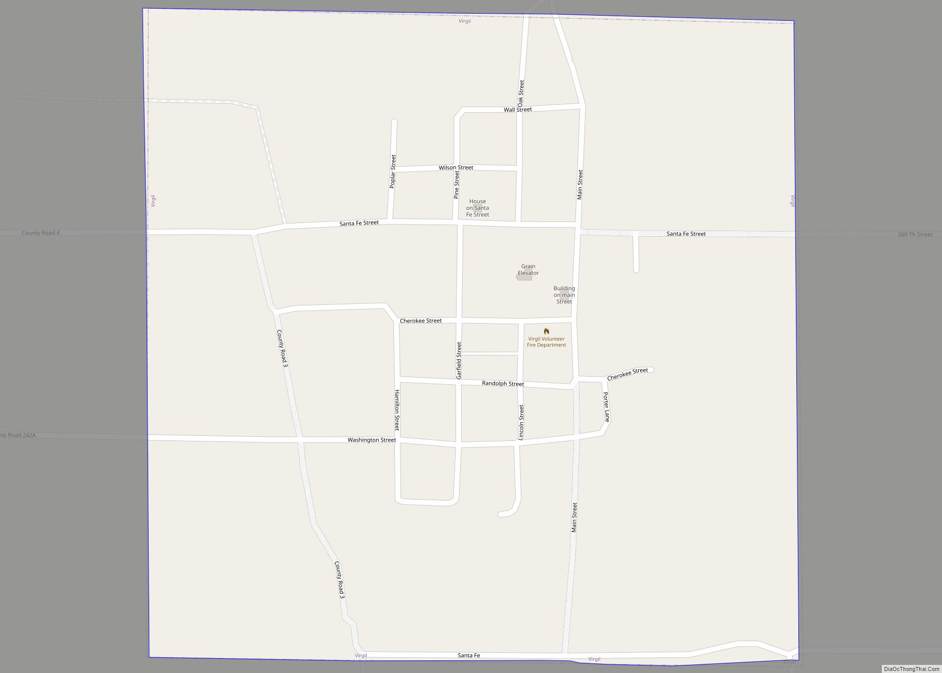
Virgil is a city in Greenwood County, Kansas, United States. As of the 2020 census, the population of the city was 48. It is located approximately 8 miles east of the city of Hamilton. Virgil city overview: Name: Virgil city LSAD Code: 25 LSAD Description: city (suffix) State: Kansas County: Greenwood County Incorporated: 1922 Elevation: ... Read more
Map of Virgil city, Kansas
Map of Wakefield city, Kansas
Wakefield is a city in Clay County, Kansas, United States. As of the 2020 census, the population of the city was 858. Wakefield city overview: Name: Wakefield city LSAD Code: 25 LSAD Description: city (suffix) State: Kansas County: Clay County Founded: 1869 Incorporated: 1887 Elevation: 1,145 ft (349 m) Total Area: 0.50 sq mi (1.29 km²) Land Area: 0.50 sq mi (1.29 km²) ... Read more
Map of Wakefield city, Kansas
Map of WaKeeney city
WaKeeney is a city in and the county seat of Trego County, Kansas, United States. As of the 2020 census, the population of the city was 1,799. WaKeeney city overview: Name: WaKeeney city LSAD Code: 25 LSAD Description: city (suffix) State: Kansas County: Trego County Founded: 1879 Incorporated: 1880 Elevation: 2,448 ft (746 m) Total Area: 1.78 sq mi ... Read more
Map of WaKeeney city
Map of Wakarusa CDP, Kansas
Wakarusa is an unincorporated community in Shawnee County, Kansas, United States. As of the 2020 census, the population of the community and nearby areas was 242. It is located 11 miles (18 km) south of downtown Topeka. Wakarusa is also the name of an unincorporated community in adjacent Douglas County, Kansas, 6.6 mi (10.6 km) southwest of downtown ... Read more
Map of Wakarusa CDP, Kansas
Map of Wallace city, Kansas
Wallace is a city in Wallace County, Kansas, United States. As of the 2020 census, the population of the city was 41. Wallace city overview: Name: Wallace city LSAD Code: 25 LSAD Description: city (suffix) State: Kansas County: Wallace County Founded: 1870s Incorporated: 1887 Elevation: 3,314 ft (1,010 m) Total Area: 0.40 sq mi (1.04 km²) Land Area: 0.40 sq mi (1.04 km²) ... Read more
Map of Wallace city, Kansas
Map of Waldron city, Kansas
Waldron is a city in Harper County, Kansas, United States. As of the 2020 census, the population of the city was 9. The south edge of the city is the Kansas / Oklahoma state border. Waldron city overview: Name: Waldron city LSAD Code: 25 LSAD Description: city (suffix) State: Kansas County: Harper County Founded: 1900 ... Read more
Map of Waldron city, Kansas
Map of Waldo city, Kansas
Waldo is a city in Waldo Township, Russell County, Kansas, United States. As of the 2020 census, the population of the city was 30. Waldo city overview: Name: Waldo city LSAD Code: 25 LSAD Description: city (suffix) State: Kansas County: Russell County Founded: 1888 Incorporated: 1911 Elevation: 1,713 ft (522 m) Total Area: 0.38 sq mi (0.97 km²) Land Area: ... Read more
Map of Waldo city, Kansas
Map of Wamego city
Wamego /wɔːˈmiːɡoʊ/ is a city in Pottawatomie County, Kansas, United States. As of the 2020 census, the population of the city was 4,841. Wamego city overview: Name: Wamego city LSAD Code: 25 LSAD Description: city (suffix) State: Kansas County: Pottawatomie County, Wabaunsee County Incorporated: 1869 Elevation: 991 ft (302 m) Total Area: 2.41 sq mi (6.25 km²) Land Area: 2.37 sq mi ... Read more
Map of Wamego city
Map of Walton city, Kansas
Walton is a city in Harvey County, Kansas, United States. It is named in honor of one of the 19th century stockholders of Atchison, Topeka and Santa Fe Railway. As of the 2020 census, the population of the city was 219. Walton city overview: Name: Walton city LSAD Code: 25 LSAD Description: city (suffix) State: ... Read more
Map of Walton city, Kansas
Map of Walnut city, Kansas
Walnut is a city in Crawford County, Kansas, United States. As of the 2020 census, the population of the city was 187. Walnut city overview: Name: Walnut city LSAD Code: 25 LSAD Description: city (suffix) State: Kansas County: Crawford County Founded: 1871 Incorporated: 1874 Elevation: 932 ft (284 m) Total Area: 1.49 sq mi (3.86 km²) Land Area: 1.47 sq mi (3.82 km²) ... Read more
Map of Walnut city, Kansas