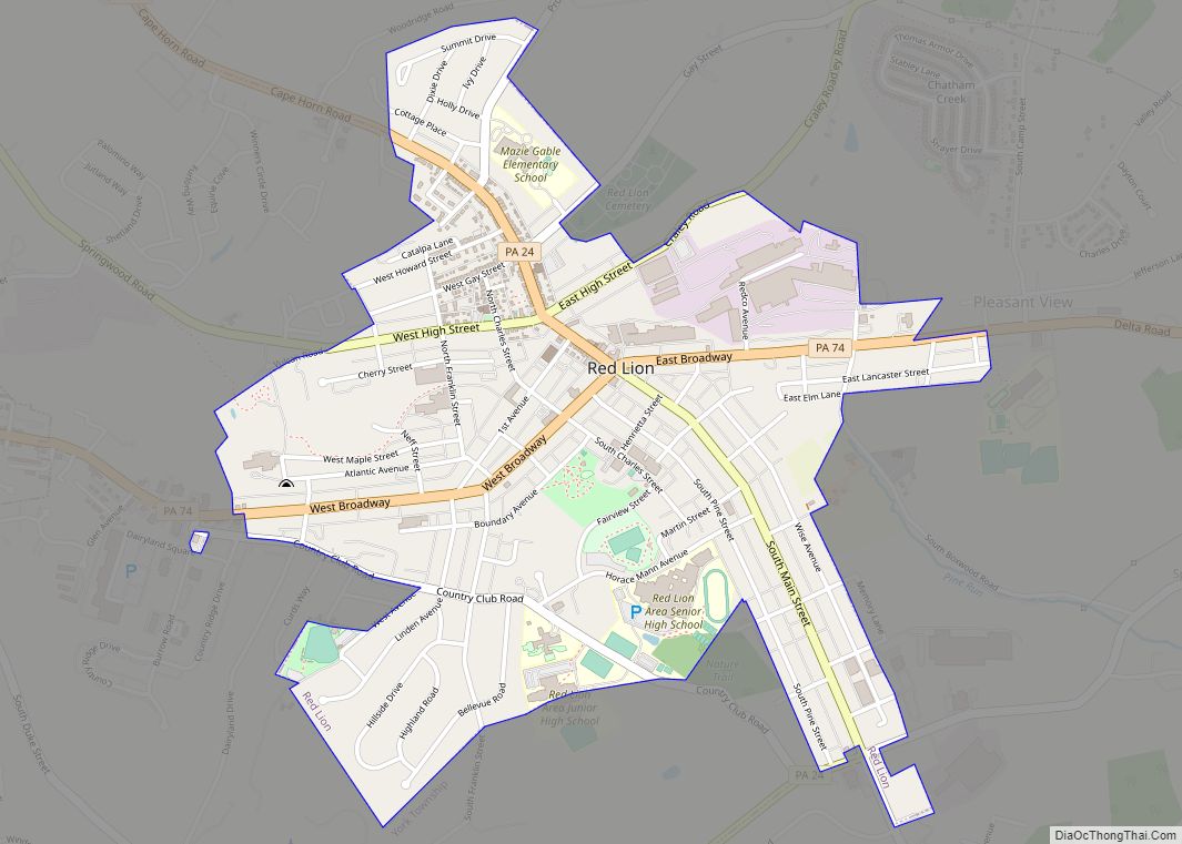
Map of Raubsville CDP
Raubsville is a census-designated place in Williams Township, Pennsylvania. The population of Raubsville was 1,079 residents as of the 2020 census. Raubsville is located along PA Route 611 on the west bank of the Delaware River. It is part of the Lehigh Valley metropolitan area, which had a population of 861,899 and was the 68th-most ... Read more
Map of Raubsville CDP
Map of Ranshaw CDP
Ranshaw is a census-designated place located in Coal Township, Northumberland County in the state of Pennsylvania. The community is located to the east of the city of Shamokin. As of the 2010 census the population was 510 residents. Ranshaw CDP overview: Name: Ranshaw CDP LSAD Code: 57 LSAD Description: CDP (suffix) State: Pennsylvania County: Northumberland ... Read more
Map of Ranshaw CDP
Map of Rankin borough, Pennsylvania
Rankin is a borough in Allegheny County, Pennsylvania, United States, 8 miles (13 km) south of Pittsburgh on the Monongahela River. The borough was named after Thomas Rankin, a local landowner. Early in the 20th century, Rankin specialized in manufacturing steel and wire goods. The population increased from 3,775 in 1900 to 7,470 in 1940, and ... Read more
Map of Rankin borough, Pennsylvania
Map of Reedsville CDP, Pennsylvania
Reedsville is a census-designated place (CDP) in the Kishacoquillas Valley of Mifflin County, Pennsylvania, United States. The population was 641 at the 2010 census. Reedsville has a high Amish population. Reedsville CDP overview: Name: Reedsville CDP LSAD Code: 57 LSAD Description: CDP (suffix) State: Pennsylvania County: Mifflin County Elevation: 592 ft (180 m) Total Area: 0.68 sq mi (1.77 km²) ... Read more
Map of Reedsville CDP, Pennsylvania
Map of Revloc CDP
Revloc is an unincorporated community and census-designated place in Cambria Township, Cambria County, Pennsylvania, United States. It is located near the intersections of US Routes 422 and 219, and is approximately 2 miles (3 km) west of the borough of Ebensburg, the Cambria County seat. As of the 2010 census, the population of Revloc was 570. ... Read more
Map of Revloc CDP
Map of Republic CDP, Pennsylvania
Republic is an unincorporated community and census-designated place (CDP) in Fayette County, Pennsylvania, United States. The population was 1,096 at the 2010 census, down from 1,396 at the 2000 census. The community is in Redstone Township. Republic CDP overview: Name: Republic CDP LSAD Code: 57 LSAD Description: CDP (suffix) State: Pennsylvania County: Fayette County Total ... Read more
Map of Republic CDP, Pennsylvania
Map of Renovo borough
Renovo is a borough in Clinton County, Pennsylvania, United States, 28 miles (45 km) northwest of Lock Haven. In 1900, 4,082 people lived there, and in 1910, 4,621 lived there, but in the 2010 census the borough population was 1,228. The borough is located on the West Branch Susquehanna River, and along Pennsylvania’s Bucktail State Park ... Read more
Map of Renovo borough
Map of Renningers CDP
Renningers is a census-designated place (CDP) in Schuylkill County, Pennsylvania, United States. The population was 380 at the 2000 census. Renningers CDP overview: Name: Renningers CDP LSAD Code: 57 LSAD Description: CDP (suffix) State: Pennsylvania County: Schuylkill County Total Area: 1.2 sq mi (3.0 km²) Land Area: 1.2 sq mi (3.0 km²) Total Population: 380 Population Density: 330/sq mi (130/km²) FIPS code: ... Read more
Map of Renningers CDP
Map of Rennerdale CDP
Rennerdale is an unincorporated community and census-designated place in Collier Township, Allegheny County, Pennsylvania, United States, about 9 miles (14 km) southwest of Pittsburgh. As of the 2020 census it had a population of 1,103. Rennerdale CDP overview: Name: Rennerdale CDP LSAD Code: 57 LSAD Description: CDP (suffix) State: Pennsylvania County: Allegheny County Total Area: 0.8 sq mi ... Read more
Map of Rennerdale CDP
Map of Reinholds CDP
Reinholds is an unincorporated community and census-designated place (CDP) in West Cocalico Township, Lancaster County, Pennsylvania, United States. As of the 2010 census the population was 1,803. The Reinholds Station Trinity Chapel was listed on the National Register of Historic Places in 1990. Reinholds CDP overview: Name: Reinholds CDP LSAD Code: 57 LSAD Description: CDP ... Read more
Map of Reinholds CDP
Map of Reinerton CDP
Reinerton is a census-designated place located in Porter Township, Schuylkill County in the state of Pennsylvania, United States. Reinerton was part of the Reinerton-Orwin-Muir CDP at the 2000 census before splitting into three individual CDPs for the 2010 census. The other communities, along with Reinerton are Orwin and Muir. The community is located near the ... Read more
Map of Reinerton CDP
Map of Reiffton CDP
Reiffton is a census-designated place (CDP) in Exeter Township, Berks County, Pennsylvania, United States. The population was 4,178 at the 2010 census. Reiffton CDP overview: Name: Reiffton CDP LSAD Code: 57 LSAD Description: CDP (suffix) State: Pennsylvania County: Berks County Elevation: 397 ft (121 m) Total Area: 1.6 sq mi (4 km²) Land Area: 1.6 sq mi (4 km²) Water Area: 0.0 sq mi (0 km²) ... Read more
Map of Reiffton CDP