Map of Philadelphia city, Pennsylvania

Map of Philadelphia city, Pennsylvania

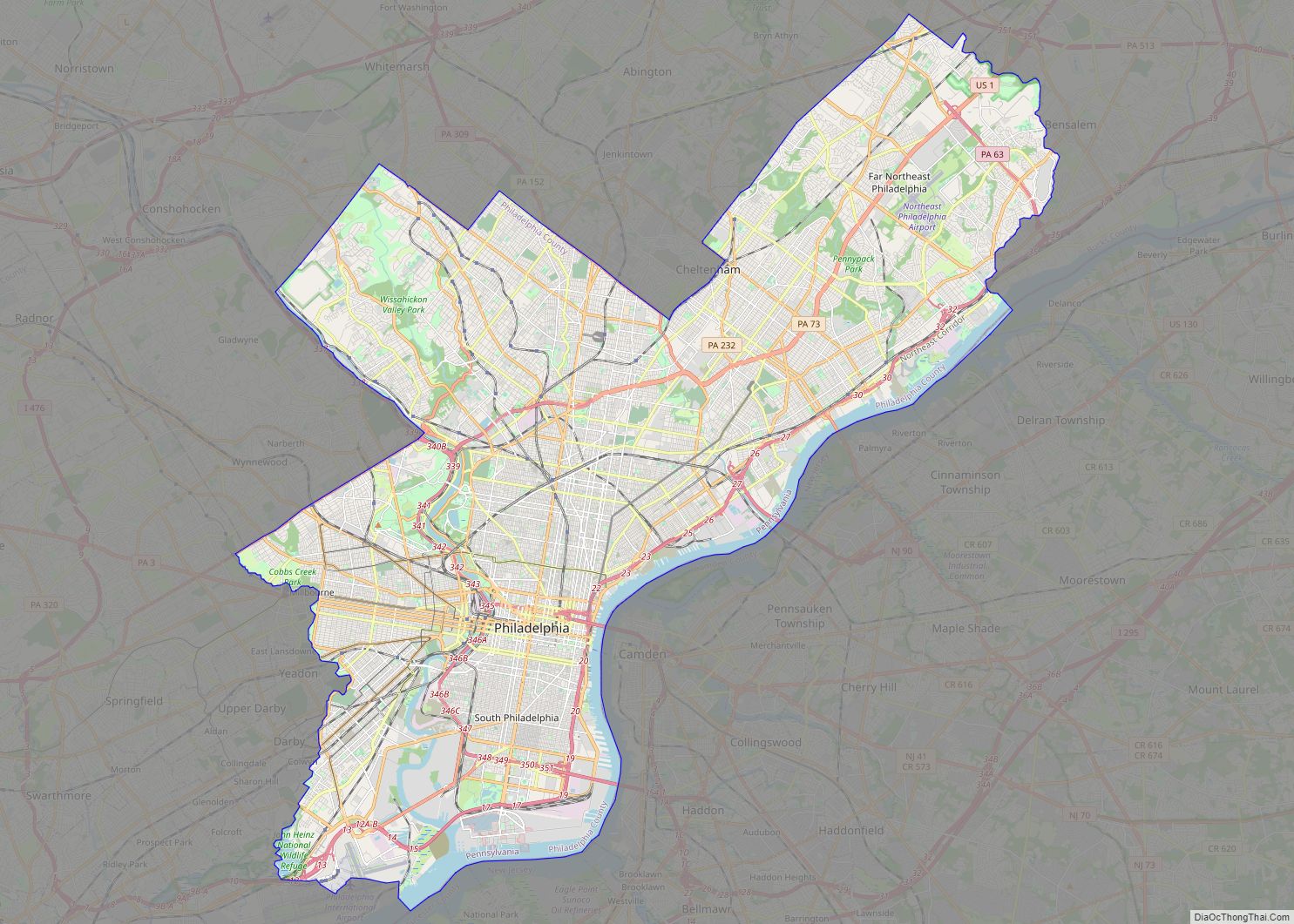
Philadelphia city overview: Name: Philadelphia city LSAD Code: 25 LSAD Description: city (suffix) State: Pennsylvania County: Philadelphia County Founded: 1682 Incorporated: October 25, 1701 Elevation: 39 ft (12 m) Land Area: 134.36 sq mi (347.98 km²) Water Area: 8.34 sq mi (21.61 km²) Population Density: 11,936.92/sq mi (4,608.86/km²) FIPS code: 4260000 GNISfeature ID: 1215531 Website: www.phila.gov This Philadelphia map collection showcases the city’s highways, … Read more

Map of Pittsburgh city

Map of Pittsburgh city

Pittsburgh (/ˈpɪtsbɜːrɡ/ PITS-burg) is a city in the Commonwealth of Pennsylvania and the county seat of Allegheny County. It is the most populous city in both Allegheny County and Western Pennsylvania, the second-most populous city in Pennsylvania after Philadelphia, and the 68th-most populous city in the U.S. with a population of 302,971 as of the … Read more

Map of Allentown city, Pennsylvania

Map of Allentown city, Pennsylvania

Allentown (Pennsylvania Dutch: Allenschteddel, Allenschtadt, or Ellsdaun) is a city in Lehigh County in the Commonwealth of Pennsylvania, United States. The city had a population of 125,845 at the 2020 census. Allentown is the fastest-growing major city in Pennsylvania and the state’s third-largest city after Philadelphia and Pittsburgh. It is the largest city in both … Read more

Map of Abbottstown borough

Map of Abbottstown borough

Abbottstown borough overview: Name: Abbottstown borough LSAD Code: 21 LSAD Description: borough (suffix) State: Pennsylvania County: Adams County FIPS code: 4200116 Online Interactive Map Abbottstown online map. Source: Basemap layers from Google Map, Open Street Map (OSM), Arcgisonline, Wmflabs. Boundary Data from Database of Global Administrative Areas. Abbottstown location map. Where is Abbottstown borough? Abbottstown … Read more

Map of Aaronsburg CDP

Map of Aaronsburg CDP

Aaronsburg is a census-designated place located in East Bethlehem Township, Washington County in the state of Pennsylvania. The community is located just to the north of Fredericktown along Pennsylvania Route 88 which travels along the Monongahela River. As of the 2010 census the population was 259 residents. Aaronsburg CDP overview: Name: Aaronsburg CDP LSAD Code: … Read more

Map of Adamsville CDP, Pennsylvania

Map of Adamsville CDP, Pennsylvania

Adamsville is a census-designated place (CDP) in Crawford County, Pennsylvania, United States. The population was 67 at the 2010 census, down from 117 in 2000. Adamsville CDP overview: Name: Adamsville CDP LSAD Code: 57 LSAD Description: CDP (suffix) State: Pennsylvania County: Crawford County Elevation: 1,040 ft (320 m) Total Area: 0.39 sq mi (1.02 km²) Land Area: 0.39 sq mi (1.02 km²) Water … Read more

Map of Adamstown borough, Pennsylvania

Map of Adamstown borough, Pennsylvania

Adamstown (Pennsylvania Dutch: Adamschteddel) is a borough in Lancaster County and Berks County in the U.S. state of Pennsylvania. The population was 1,789 at the 2010 census. Of this, 1,772 were in Lancaster County and only 17 were in Berks County. Adamstown borough overview: Name: Adamstown borough LSAD Code: 21 LSAD Description: borough (suffix) State: … Read more

Map of Adamsburg borough

Map of Adamsburg borough

Adamsburg is a borough in Westmoreland County, Pennsylvania, United States. The population was 144 at the time of the 2020 federal census. The borough was named for John Quincy Adams, sixth President of the United States. Adamsburg borough overview: Name: Adamsburg borough LSAD Code: 21 LSAD Description: borough (suffix) State: Pennsylvania County: Westmoreland County Incorporated: … Read more

Map of Ackermanville CDP

Map of Ackermanville CDP

Ackermanville is a census-designated place located on PA Route 191 in Washington Township, Pennsylvania. As of the 2020 census, the village’s population was 572. Ackermanville is part of the Lehigh Valley metropolitan area, which had a population of 861,899 and was the 68th-most populous metropolitan area in the U.S. as of the 2020 census. It … Read more