Map of York Haven borough

Map of York Haven borough

York Haven is a borough in York County, Pennsylvania, United States. The population was 691 at the 2020 census. The borough is the home of the Brunner Island coal-fired electrical generation plant, located on the Susquehanna River on Wago Road and operated by PPL Corporation. York Haven borough overview: Name: York Haven borough LSAD Code: … Read more

Map of Yoe borough

Map of Yoe borough

Yoe borough overview: Name: Yoe borough LSAD Code: 21 LSAD Description: borough (suffix) State: Pennsylvania County: York County FIPS code: 4287040 Online Interactive Map Yoe online map. Source: Basemap layers from Google Map, Open Street Map (OSM), Arcgisonline, Wmflabs. Boundary Data from Database of Global Administrative Areas. Yoe location map. Where is Yoe borough? Yoe … Read more

Map of Yeagertown CDP

Map of Yeagertown CDP

Yeagertown is a census-designated place (CDP) in Mifflin County, Pennsylvania, United States. The population was 1,035 at the 2000 census. Yeagertown CDP overview: Name: Yeagertown CDP LSAD Code: 57 LSAD Description: CDP (suffix) State: Pennsylvania County: Mifflin County Total Area: 0.5 sq mi (1.2 km²) Land Area: 0.5 sq mi (1.2 km²) Total Population: 1,035 Population Density: 2,200/sq mi (860/km²) ZIP code: … Read more

Map of Yeadon borough

Map of Yeadon borough

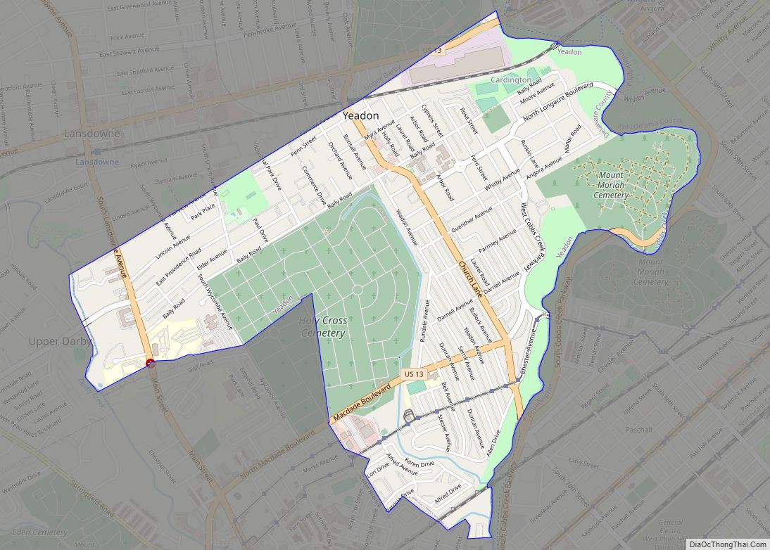
Yeadon is a borough in Delaware County, Pennsylvania, United States. It borders the city of Philadelphia. The population was 11,443 at the 2010 census. Yeadon borough overview: Name: Yeadon borough LSAD Code: 21 LSAD Description: borough (suffix) State: Pennsylvania County: Delaware County Incorporated: 1893 Elevation: 69 ft (21 m) Total Area: 1.59 sq mi (4.13 km²) Land Area: 1.59 sq mi (4.13 km²) … Read more

Map of Yatesville borough, Pennsylvania

Map of Yatesville borough, Pennsylvania

Yatesville borough overview: Name: Yatesville borough LSAD Code: 21 LSAD Description: borough (suffix) State: Pennsylvania County: Luzerne County FIPS code: 4286952 Online Interactive Map Yatesville online map. Source: Basemap layers from Google Map, Open Street Map (OSM), Arcgisonline, Wmflabs. Boundary Data from Database of Global Administrative Areas. Yatesville location map. Where is Yatesville borough? Yatesville … Read more

Map of Yardley borough

Map of Yardley borough

Yardley is a borough in Bucks County, Pennsylvania. Yardley borders the Delaware River and Ewing, New Jersey to its east and Lower Makefield Township to its north, west, and south. The United States Post Office assigns many addresses in Lower Makefield Township the preferred city of “Yardley”, although they are outside the borough. The population … Read more

Map of Zelienople borough

Map of Zelienople borough

Zelienople /ˌziːliəˈnoʊpəl/ is a borough in Butler County, Pennsylvania, 28 miles (45 km) north of Pittsburgh. The population was 3,812 at the 2010 census. It is part of the Pittsburgh metropolitan area. Zelienople borough overview: Name: Zelienople borough LSAD Code: 21 LSAD Description: borough (suffix) State: Pennsylvania County: Butler County Incorporated: 1840 Total Area: 2.10 sq mi (5.44 km²) … Read more

Map of Yukon CDP, Pennsylvania

Map of Yukon CDP, Pennsylvania

Yukon is a census-designated place located in South Huntingdon Township, Westmoreland County in the state of Pennsylvania, United States. The community is located near Interstate 70, north of the village of Wyano. As of the 2010 census the population was 677 residents. Yukon CDP overview: Name: Yukon CDP LSAD Code: 57 LSAD Description: CDP (suffix) … Read more

Map of Youngwood borough

Map of Youngwood borough

Youngwood is a borough in Westmoreland County, Pennsylvania, United States. Youngwood borough overview: Name: Youngwood borough LSAD Code: 21 LSAD Description: borough (suffix) State: Pennsylvania County: Westmoreland County Incorporated: November 10, 1902 Elevation: 954 ft (291 m) Total Area: 1.92 sq mi (4.98 km²) Land Area: 1.92 sq mi (4.97 km²) Water Area: 0.00 sq mi (0.01 km²) Total Population: 2,975 Area code: 724 FIPS code: … Read more

Map of Youngsville borough, Pennsylvania

Map of Youngsville borough, Pennsylvania

Youngsville is a borough in Warren County, Pennsylvania, United States. The population was 1,729 at the 2010 census. Youngsville borough overview: Name: Youngsville borough LSAD Code: 21 LSAD Description: borough (suffix) State: Pennsylvania County: Warren County Founded: 1796 Total Area: 1.33 sq mi (3.45 km²) Land Area: 1.33 sq mi (3.45 km²) Water Area: 0.00 sq mi (0.00 km²) Total Population: 1,729 Population Density: … Read more

Map of Youngstown borough, Pennsylvania

Map of Youngstown borough, Pennsylvania

Youngstown is a borough in Westmoreland County, Pennsylvania, United States. Youngstown was incorporated on April 2, 1831. The population was 326 at the 2010 census. The borough has its own post office, with zip code 15696, established on April 1, 1813. Youngstown borough overview: Name: Youngstown borough LSAD Code: 21 LSAD Description: borough (suffix) State: … Read more

Map of Zion CDP, Pennsylvania

Map of Zion CDP, Pennsylvania

Zion is an unincorporated community and census-designated place (CDP) in Centre County, Pennsylvania, United States. Zion CDP overview: Name: Zion CDP LSAD Code: 57 LSAD Description: CDP (suffix) State: Pennsylvania County: Centre County Elevation: 1,010 ft (310 m) Total Area: 2.88 sq mi (7.46 km²) Land Area: 2.88 sq mi (7.46 km²) Water Area: 0.0 sq mi (0.0 km²) Total Population: 2,036 Population Density: 705/sq mi (272.1/km²) … Read more