Map of Roscoe borough, Pennsylvania
Roscoe is a borough in Washington County, Pennsylvania, United States. The population was 716 at the 2020 census. Roscoe borough overview: Name: Roscoe borough LSAD Code: 21 LSAD Description: borough (suffix) State: Pennsylvania County: Washington County Total Area: 0.25 sq mi (0.64 km²) Land Area: 0.18 sq mi (0.47 km²) Water Area: 0.06 sq mi (0.17 km²) Total Population: 720 Population Density: 3,956.04/sq mi (1,528.02/km²) ... Read more
Map of Roscoe borough, Pennsylvania
Map of Ronks CDP
Ronks is a small unincorporated farming community and census-designated place (CDP) in East Lampeter Township, Lancaster County, Pennsylvania, United States, just west of Paradise. As of the 2010 census the population was 362. The community is the home of Ronks Concrete Company and has a large Amish and Mennonite population. The Ronks ZIP code of ... Read more
Map of Ronks CDP
Map of Ronco CDP
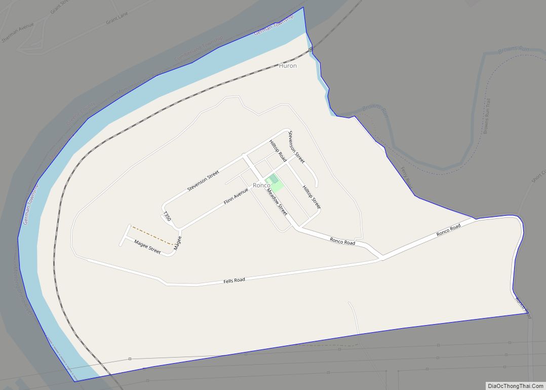
Ronco is an unincorporated community and census-designated place in German Township, Fayette County, Pennsylvania, United States. It is located 2 miles (3 km) north of the borough of Masontown, along the east bank of the Monongahela River. As of the 2010 census, the population of Ronco was 256. Ronco CDP overview: Name: Ronco CDP LSAD Code: ... Read more
Map of Ronco CDP
Map of Rome borough, Pennsylvania
Rome is a borough in Bradford County, Pennsylvania, United States. It is part of Northeastern Pennsylvania. The population was 385 at the 2020 census. Rome borough overview: Name: Rome borough LSAD Code: 21 LSAD Description: borough (suffix) State: Pennsylvania County: Bradford County Incorporated: 1860 Elevation: 837 ft (255 m) Total Area: 0.53 sq mi (1.37 km²) Land Area: 0.52 sq mi (1.34 km²) ... Read more
Map of Rome borough, Pennsylvania
Map of Rohrsburg CDP
Rohrsburg is a census-designated place (CDP) in Columbia County, Pennsylvania, United States. It is part of Northeastern Pennsylvania. The population was 145 at the 2010 census. It is part of the Bloomsburg-Berwick micropolitan area. Rohrsburg CDP overview: Name: Rohrsburg CDP LSAD Code: 57 LSAD Description: CDP (suffix) State: Pennsylvania County: Columbia County Elevation: 661 ft (201 m) ... Read more
Map of Rohrsburg CDP
Map of Rogersville CDP, Pennsylvania
Rogersville is an unincorporated community and census-designated place (CDP) in Center Township, Greene County, Pennsylvania, United States. It is located 6 miles (10 km) west of the borough of Waynesburg (the Greene County seat) along Pennsylvania Route 18. As of the 2010 census the population was 249. Rogersville CDP overview: Name: Rogersville CDP LSAD Code: 57 ... Read more
Map of Rogersville CDP, Pennsylvania
Map of Rockwood borough, Pennsylvania
Rockwood is a borough in Somerset County, Pennsylvania, United States. The population was 850 at the 2020 census. It is part of the Johnstown, Pennsylvania, Metropolitan Statistical Area, and located due north of Pennsylvania’s highest peak, Mount Davis, which significantly constricts land travel routing south of the municipality. Rockwood borough overview: Name: Rockwood borough LSAD ... Read more
Map of Rockwood borough, Pennsylvania
Map of Rockledge borough, Pennsylvania
Rockledge is a borough in Montgomery County, Pennsylvania, United States. The population was 2,638 as of the 2020 census. Rockledge is surrounded by Abington Township and the city of Philadelphia, and shares a ZIP code with Jenkintown. Rockledge borough overview: Name: Rockledge borough LSAD Code: 21 LSAD Description: borough (suffix) State: Pennsylvania County: Montgomery County ... Read more
Map of Rockledge borough, Pennsylvania
Map of Roulette CDP
Roulette is a census-designated place located in Roulette Township in far western Potter County in the state of Pennsylvania, United States. It is located along the Allegheny River, approximately 20 miles southwest of the river’s source. The town is also on U.S. Route 6, roughly halfway between Port Allegany and Coudersport. As of the 2010 ... Read more
Map of Roulette CDP
Map of Rothsville CDP
Rothsville is an unincorporated community and census-designated place (CDP) in Warwick Township, Lancaster County, Pennsylvania, United States. The population was 3,044 at the 2010 census. Lititz is the town for residents’ mailing addresses. Rothsville CDP overview: Name: Rothsville CDP LSAD Code: 57 LSAD Description: CDP (suffix) State: Pennsylvania County: Lancaster County Elevation: 490 ft (150 m) Total ... Read more
Map of Rothsville CDP
Map of Rote CDP
Rote is a census-designated place located in Lamar Township in southern Clinton County, Pennsylvania, United States. As of the 2010 census, the population was 507. Rote is located near the center of Lamar Township in southern Clinton County, along Pennsylvania Route 477 near the northeastern end of the Nittany Valley. PA 477 leads west 3 ... Read more
Map of Rote CDP
Map of Rosslyn Farms borough
Rosslyn Farms is a suburban borough located 5 miles (8 km) west of Pittsburgh in Allegheny County, Pennsylvania, United States. It is a small community, with an area of only 0.6 square miles (1.6 km). The population was 441 at the 2020 census. Rosslyn Farms borough overview: Name: Rosslyn Farms borough LSAD Code: 21 LSAD Description: borough ... Read more
Map of Rosslyn Farms borough