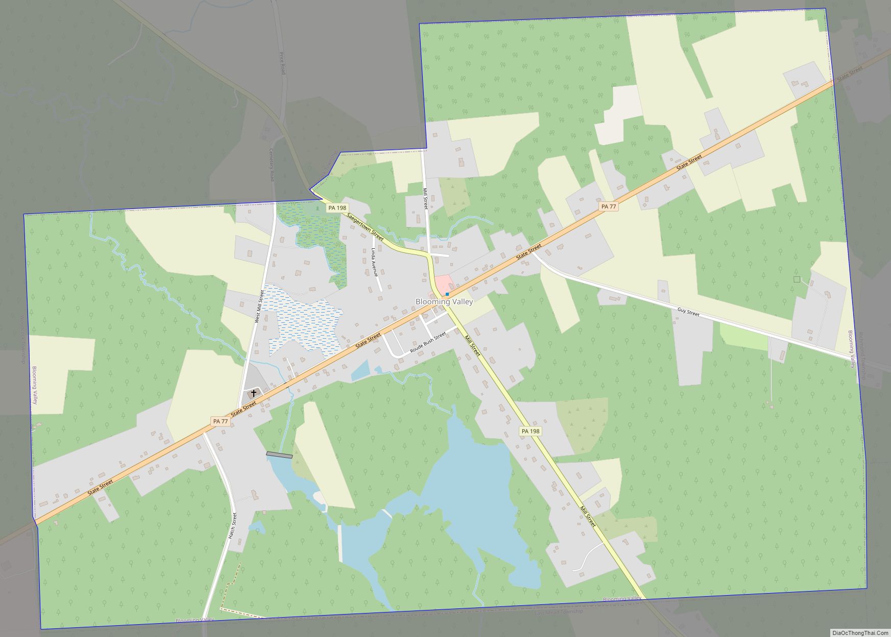
Map of Blawnox borough
Blawnox is a borough in Allegheny County, Pennsylvania, United States. The population was 1,454 at the 2020 census. Blawnox borough overview: Name: Blawnox borough LSAD Code: 21 LSAD Description: borough (suffix) State: Pennsylvania County: Allegheny County Incorporated: April 13, 1925; 98 years ago (1925-04-13) Elevation: 843 ft (257 m) Total Area: 0.44 sq mi (1.14 km²) Land Area: 0.30 sq mi (0.77 km²) Water Area: ... Read more
Map of Blawnox borough
Map of Bobtown CDP, Pennsylvania
Bobtown is an unincorporated coal town and census-designated place (CDP) in Greene County, Pennsylvania, United States. As of the 2010 census it had a population of 757. Bobtown CDP overview: Name: Bobtown CDP LSAD Code: 57 LSAD Description: CDP (suffix) State: Pennsylvania County: Greene County Elevation: 1,178 ft (359 m) Total Area: 0.62 sq mi (1.59 km²) Land Area: 0.62 sq mi ... Read more
Map of Bobtown CDP, Pennsylvania
Map of Boalsburg CDP
Boalsburg is an unincorporated community and census-designated place (CDP) in Harris Township, Centre County, Pennsylvania, United States. It is part of the State College, Pennsylvania Metropolitan Statistical Area. The population was 3,722 at the 2010 census. The village claims to be the birthplace of Memorial Day. However, that claim was brought into question by Bellware ... Read more
Map of Boalsburg CDP
Map of Blue Ridge Summit CDP
Blue Ridge Summit is an unincorporated community and census-designated place in Franklin County, Pennsylvania, United States, southwest of Gettysburg in the central part of the state, adjoining Pennsylvania’s southern border with Maryland. It is less than 3 miles (5 km) east of Pen Mar, Maryland. The population of Blue Ridge Summit was 887 at the 2020 ... Read more
Map of Blue Ridge Summit CDP
Map of Blue Bell CDP
Blue Bell is a census-designated place (CDP) in Whitpain Township, Montgomery County, Pennsylvania, United States. As of the 2010 census, its population was 6,067. Blue Bell was originally known as Pigeontown, after the large flocks of the now-extinct passenger pigeons that once gathered there. The town was renamed in 1840 after the historically prominent Blue ... Read more
Map of Blue Bell CDP
Map of Blue Ball CDP
Blue Ball is an unincorporated community and census-designated place (CDP) in East Earl Township, Lancaster County, Pennsylvania, United States. Blue Ball lies approximately 2 miles (3 km) east-northeast of the borough of New Holland at the intersection of US 322 and PA Route 23. As of the 2010 census, the population was 1,031. Blue Ball CDP ... Read more
Map of Blue Ball CDP
Map of Blossburg borough
Blossburg is a borough in Tioga County, Pennsylvania, United States. The population was 1,536 at the 2020 census. Blossburg borough overview: Name: Blossburg borough LSAD Code: 21 LSAD Description: borough (suffix) State: Pennsylvania County: Tioga County Elevation: 1,342 ft (409 m) Total Area: 4.65 sq mi (12.03 km²) Land Area: 4.65 sq mi (12.03 km²) Water Area: 0.00 sq mi (0.00 km²) Total Population: 1,533 Population ... Read more
Map of Blossburg borough
Map of Bloomsburg town
Bloomsburg is a town and the county seat of Columbia County, Pennsylvania, United States. It is part of Northeastern Pennsylvania and is located 40 miles (64 km) southwest of Wilkes-Barre along the Susquehanna River. It is the only Pennsylvania municipality incorporated as a town. As of the 2010 census, Bloomsburg had a population of 14,855, with ... Read more
Map of Bloomsburg town
Map of Bowmansville CDP
Bowmansville is an unincorporated community and census-designated place (CDP) in Brecknock Township, Lancaster County, Pennsylvania, United States. Bowmansville is home to a Pennsylvania Turnpike service plaza. The population was 2,077 as of the 2010 census. Bowmansville CDP overview: Name: Bowmansville CDP LSAD Code: 57 LSAD Description: CDP (suffix) State: Pennsylvania County: Lancaster County Founded: 1820 ... Read more
Map of Bowmansville CDP
Map of Bowmanstown borough
Bowmanstown is a borough in Carbon County, Pennsylvania. It is part of Northeastern Pennsylvania. The population was 937 at the 2010 census. The borough is at an elevation of 437 feet (133 m). It is located 3 miles (5 km) west of Palmerton and 4 miles (6 km) south of Lehighton off Pennsylvania Route 248. Bowmanstown borough overview: ... Read more
Map of Bowmanstown borough
Map of Bowers CDP, Pennsylvania
Bowers is a census-designated place in Maxatawny Township, Berks County, Pennsylvania, United States. It is located near the borough of Lyons and is on Sacony Creek, a tributary of the Maiden Creek. As of the 2010 census, the population was 326 residents. Although Bowers has its own post office with the ZIP code of 19511, ... Read more
Map of Bowers CDP, Pennsylvania
Map of Boswell borough, Pennsylvania
Boswell is a borough in Somerset County, Pennsylvania, United States. It is part of the Johnstown, Pennsylvania Metropolitan Statistical Area. The population was 1,221 at the 2020 census. Boswell borough overview: Name: Boswell borough LSAD Code: 21 LSAD Description: borough (suffix) State: Pennsylvania County: Somerset County Incorporated: February 22, 1904 Total Area: 0.74 sq mi (1.91 km²) Land ... Read more
Map of Boswell borough, Pennsylvania