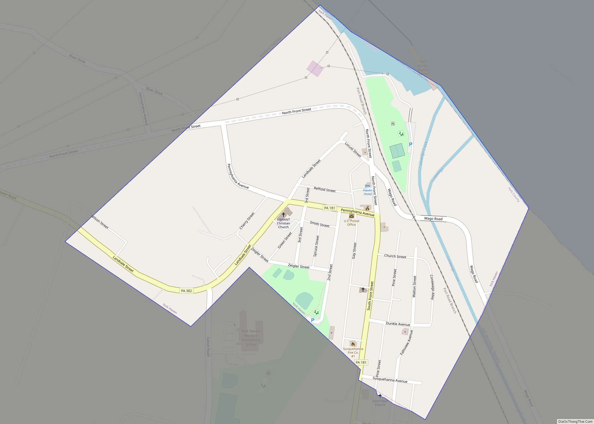
Map of Yatesville borough, Pennsylvania

Map of Yatesville borough, Pennsylvania

Yatesville borough overview: Name: Yatesville borough LSAD Code: 21 LSAD Description: borough (suffix) State: Pennsylvania County: Luzerne County FIPS code: 4286952 Online Interactive Map Yatesville online map. Source: Basemap layers from Google Map, Open Street Map (OSM), Arcgisonline, Wmflabs. Boundary Data from Database of Global Administrative Areas. Yatesville location map. Where is Yatesville borough? Yatesville … Read more

Map of Yardley borough

Map of Yardley borough

Yardley is a borough in Bucks County, Pennsylvania. Yardley borders the Delaware River and Ewing, New Jersey to its east and Lower Makefield Township to its north, west, and south. The United States Post Office assigns many addresses in Lower Makefield Township the preferred city of “Yardley”, although they are outside the borough. The population … Read more

Map of Yorklyn CDP

Map of Yorklyn CDP

Yorklyn is a census-designated place (CDP) in York County, Pennsylvania, United States. The population was 1,912 at the 2010 census. The area was delineated as the Springetts Manor-Yorklyn CDP for the 2000 census. Yorklyn CDP overview: Name: Yorklyn CDP LSAD Code: 57 LSAD Description: CDP (suffix) State: Pennsylvania County: York County Total Area: 0.5 sq mi (1.2 km²) … Read more

Map of Yorkana borough

Map of Yorkana borough

Yorkana is a borough in York County, Pennsylvania, United States. The population was 236 at the 2020 census. It is a linear town, spread along Mt. Pisgah Road, which is called Main Street in town. The borough includes several dozen houses, two churches, and a few businesses. Yorkana borough overview: Name: Yorkana borough LSAD Code: … Read more

Map of York city, Pennsylvania

Map of York city, Pennsylvania

York (Pennsylvania Dutch: Yarrick) is a city in, and the county seat of, York County, Pennsylvania, United States. Located in South Central Pennsylvania, the city’s population was 44,800 at the time of the 2020 census, making it the tenth largest city in Pennsylvania. The city has an urban area population of 238,549 people and a … Read more

Map of York Springs borough

Map of York Springs borough

York Springs is a borough in Adams County, Pennsylvania, United States. The population was 683 at the 2020 census. York Springs is served by the Bermudian Springs School District. York Springs borough overview: Name: York Springs borough LSAD Code: 21 LSAD Description: borough (suffix) State: Pennsylvania County: Adams County Incorporated: 1868 Elevation: 650 ft (200 m) Total … Read more

Map of Zion CDP, Pennsylvania

Map of Zion CDP, Pennsylvania

Zion is an unincorporated community and census-designated place (CDP) in Centre County, Pennsylvania, United States. Zion CDP overview: Name: Zion CDP LSAD Code: 57 LSAD Description: CDP (suffix) State: Pennsylvania County: Centre County Elevation: 1,010 ft (310 m) Total Area: 2.88 sq mi (7.46 km²) Land Area: 2.88 sq mi (7.46 km²) Water Area: 0.0 sq mi (0.0 km²) Total Population: 2,036 Population Density: 705/sq mi (272.1/km²) … Read more

Map of Zelienople borough

Map of Zelienople borough

Zelienople /ˌziːliəˈnoʊpəl/ is a borough in Butler County, Pennsylvania, 28 miles (45 km) north of Pittsburgh. The population was 3,812 at the 2010 census. It is part of the Pittsburgh metropolitan area. Zelienople borough overview: Name: Zelienople borough LSAD Code: 21 LSAD Description: borough (suffix) State: Pennsylvania County: Butler County Incorporated: 1840 Total Area: 2.10 sq mi (5.44 km²) … Read more

Map of Yukon CDP, Pennsylvania

Map of Yukon CDP, Pennsylvania

Yukon is a census-designated place located in South Huntingdon Township, Westmoreland County in the state of Pennsylvania, United States. The community is located near Interstate 70, north of the village of Wyano. As of the 2010 census the population was 677 residents. Yukon CDP overview: Name: Yukon CDP LSAD Code: 57 LSAD Description: CDP (suffix) … Read more

Map of Youngwood borough

Map of Youngwood borough

Youngwood is a borough in Westmoreland County, Pennsylvania, United States. Youngwood borough overview: Name: Youngwood borough LSAD Code: 21 LSAD Description: borough (suffix) State: Pennsylvania County: Westmoreland County Incorporated: November 10, 1902 Elevation: 954 ft (291 m) Total Area: 1.92 sq mi (4.98 km²) Land Area: 1.92 sq mi (4.97 km²) Water Area: 0.00 sq mi (0.01 km²) Total Population: 2,975 Area code: 724 FIPS code: … Read more

Map of Youngsville borough, Pennsylvania

Map of Youngsville borough, Pennsylvania

Youngsville is a borough in Warren County, Pennsylvania, United States. The population was 1,729 at the 2010 census. Youngsville borough overview: Name: Youngsville borough LSAD Code: 21 LSAD Description: borough (suffix) State: Pennsylvania County: Warren County Founded: 1796 Total Area: 1.33 sq mi (3.45 km²) Land Area: 1.33 sq mi (3.45 km²) Water Area: 0.00 sq mi (0.00 km²) Total Population: 1,729 Population Density: … Read more

Map of Youngstown borough, Pennsylvania

Map of Youngstown borough, Pennsylvania

Youngstown is a borough in Westmoreland County, Pennsylvania, United States. Youngstown was incorporated on April 2, 1831. The population was 326 at the 2010 census. The borough has its own post office, with zip code 15696, established on April 1, 1813. Youngstown borough overview: Name: Youngstown borough LSAD Code: 21 LSAD Description: borough (suffix) State: … Read more