Map of Burnside borough, Pennsylvania
Burnside borough overview: Name: Burnside borough LSAD Code: 21 LSAD Description: borough (suffix) State: Pennsylvania County: Clearfield County FIPS code: 4210280 Online Interactive Map Burnside online map. Source: Basemap layers from Google Map, Open Street Map (OSM), Arcgisonline, Wmflabs. Boundary Data from Database of Global Administrative Areas. Burnside location map. Where is Burnside borough? Burnside ... Read more
Map of Burnside borough, Pennsylvania
Map of Burnham borough, Pennsylvania
Burnham is a borough in Mifflin County, Pennsylvania, United States. The population was 1,999 at the 2020 census. Burnham borough overview: Name: Burnham borough LSAD Code: 21 LSAD Description: borough (suffix) State: Pennsylvania County: Mifflin County Incorporated: 1911 Total Area: 1.07 sq mi (2.76 km²) Land Area: 1.05 sq mi (2.73 km²) Water Area: 0.01 sq mi (0.04 km²) Total Population: 1,991 Population Density: ... Read more
Map of Burnham borough, Pennsylvania
Map of Burlington borough, Pennsylvania
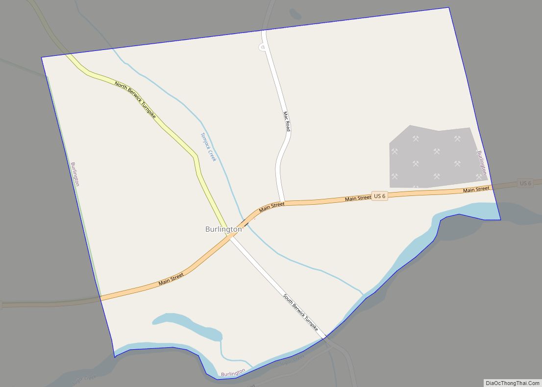
Burlington is a borough in Bradford County, Pennsylvania, United States. It is part of Northeastern Pennsylvania. The population was 145 at the 2020 census. Children residing in the township are assigned to attend the Troy Area School District. Burlington borough overview: Name: Burlington borough LSAD Code: 21 LSAD Description: borough (suffix) State: Pennsylvania County: Bradford ... Read more
Map of Burlington borough, Pennsylvania
Map of Burgettstown borough
Burgettstown is a borough in northwestern Washington County, Pennsylvania, United States. The population was 1,424 according to the 2020 census. It is part of the Pittsburgh metropolitan area. The Pavilion at Star Lake, a 23,000-seat outdoor amphitheater that hosts many of the Pittsburgh area’s headlining concerts, is located near Burgettstown. Burgettstown borough overview: Name: Burgettstown ... Read more
Map of Burgettstown borough
Map of Bulger CDP
Bulger is a census-designated place in Smith Township, Pennsylvania, United States. The ZIP Code is 15019. Bulger was a coal mining town and was the birthplace of football player Doug Russell. Among the companies located in Bulger were the Pittsburgh Coal Company, the Bulger Block Coal Company, and the Verner Coal & Coke Company. As ... Read more
Map of Bulger CDP
Map of Buffington CDP
Buffington is an unincorporated community and census-designated place in Menallen Township, Fayette County, Pennsylvania, United States. The community was part of the New Salem-Buffington CDP, before it was split into two separate CDPs for the 2010 census. The population was 292 as of the 2010 census. Buffington CDP overview: Name: Buffington CDP LSAD Code: 57 ... Read more
Map of Buffington CDP
Map of Buckhorn CDP, Pennsylvania
Buckhorn is a census-designated place (CDP) in Columbia County, Pennsylvania, United States. It is part of Northeastern Pennsylvania. The population was 318 at the 2010 census. It is part of the Bloomsburg-Berwick micropolitan area. It uses the Bloomsburg ZIP code of 17815. Buckhorn CDP overview: Name: Buckhorn CDP LSAD Code: 57 LSAD Description: CDP (suffix) ... Read more
Map of Buckhorn CDP, Pennsylvania
Map of Buck Run CDP
Buck Run is a census-designated place (CDP) in Schuylkill County, Pennsylvania, United States. The population was 176 at the 2010 census. Buck Run CDP overview: Name: Buck Run CDP LSAD Code: 57 LSAD Description: CDP (suffix) State: Pennsylvania County: Schuylkill County Total Area: 0.50 sq mi (1.30 km²) Land Area: 0.50 sq mi (1.30 km²) Water Area: 0.00 sq mi (0.00 km²) Total Population: ... Read more
Map of Buck Run CDP
Map of Bryn Mawr CDP
Bryn Mawr (pronounced /ˌbrɪnˈmɑːr/ brin-mowr, from Welsh for ‘big hill’) is a census-designated place (CDP) located across three townships: Radnor Township and Haverford Township in Delaware County, and Lower Merion Township in Montgomery County, Pennsylvania, United States. It is located just west of Philadelphia along Lancaster Avenue, also known as U.S. Route 30. Bryn Mawr ... Read more
Map of Bryn Mawr CDP
Map of Bryn Athyn borough
Bryn Athyn borough overview: Name: Bryn Athyn borough LSAD Code: 21 LSAD Description: borough (suffix) State: Pennsylvania County: Montgomery County Incorporated: 1916 Elevation: 292 ft (89 m) Total Area: 1.93 sq mi (5.00 km²) Land Area: 1.93 sq mi (5.00 km²) Water Area: 0.00 sq mi (0.00 km²) Total Population: 1,272 Population Density: 658.73/sq mi (254.32/km²) ZIP code: 19009 Area code: 215, 267, and 445 FIPS code: ... Read more
Map of Bryn Athyn borough
Map of Cairnbrook CDP
Cairnbrook is a census-designated place and coal town in Shade Township, Somerset County, Pennsylvania, United States. The community is located along Pennsylvania Route 160 within a mile of the borough of Central City. As of the 2010 census, the population was 520 residents. Cairnbrook CDP overview: Name: Cairnbrook CDP LSAD Code: 57 LSAD Description: CDP ... Read more
Map of Cairnbrook CDP
Map of Byrnedale CDP
Byrnedale is an unincorporated community and census-designated place in Elk County, Pennsylvania. As of the 2010 census, the population was 427. It is located in Jay Township, in the valley of Kersey Run, and is bordered to the south by Weedville. Pennsylvania Route 255 passes through Byrnedale, leading north 11 miles (18 km) to St. Marys ... Read more
Map of Byrnedale CDP