Map of Carroll Valley borough
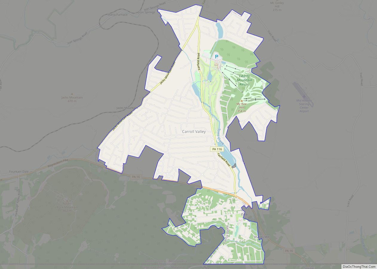
Carroll Valley is a borough in Adams County, Pennsylvania, United States. The population was 3,940 at the 2020 census. Carroll Valley borough overview: Name: Carroll Valley borough LSAD Code: 21 LSAD Description: borough (suffix) State: Pennsylvania County: Adams County Incorporated: 1974 Elevation: 807 ft (246 m) Total Area: 5.45 sq mi (14.12 km²) Land Area: 5.38 sq mi (13.93 km²) Water Area: 0.07 sq mi ... Read more
Map of Carroll Valley borough
Map of Catawissa borough
Catawissa is a borough in Columbia County, Pennsylvania, United States. It is part of Northeastern Pennsylvania. The population was 1,539 at the 2020 census. It is part of the Bloomsburg-Berwick micropolitan area. Catawissa is twinned with Uxbridge, Ontario. The historic link began in 1805, when the Uxbridge area was granted by the British crown to ... Read more
Map of Catawissa borough
Map of Catasauqua borough
Catasauqua, referred to colloquially as Catty, is a borough in Lehigh County, Pennsylvania. Catasauqua’s population was 6,518 at the 2020 census. It is a suburb of Allentown in the Lehigh Valley, which had a population of 861,899 and was the 68th-most populous metropolitan area in the U.S. as of the 2020 census. In 1839, Catasauqua ... Read more
Map of Catasauqua borough
Map of Castle Shannon borough
Castle Shannon is a borough in Allegheny County, Pennsylvania, United States, and is part of the Pittsburgh Metro Area. The population was 8,249 at the 2020 census. Castle Shannon borough overview: Name: Castle Shannon borough LSAD Code: 21 LSAD Description: borough (suffix) State: Pennsylvania County: Allegheny County Incorporated: December 20, 1919 Elevation: 1,040 ft (320 m) Total ... Read more
Map of Castle Shannon borough
Map of Chalfant borough, Pennsylvania
Chalfant is a borough in Allegheny County, Pennsylvania, United States. The population was 748 at the 2020 census. The borough was named after the Chalfant family of early settlers. Chalfant borough overview: Name: Chalfant borough LSAD Code: 21 LSAD Description: borough (suffix) State: Pennsylvania County: Allegheny County Total Area: 0.16 sq mi (0.41 km²) Land Area: 0.16 sq mi (0.41 km²) ... Read more
Map of Chalfant borough, Pennsylvania
Map of Cetronia CDP
Cetronia is a census-designated place (CDP) in South Whitehall Township in Lehigh County, Pennsylvania, located near Allentown. As of the 2020 census, its population was 2,421. Cetronia is part of the Lehigh Valley metropolitan area, which had a population of 861,899 and was the 68th-most populous metropolitan area in the U.S. as of the 2020 ... Read more
Map of Cetronia CDP
Map of Centre Hall borough
Centre Hall is a borough in Centre County, Pennsylvania, United States. It is located in Penns Valley and is part of the State College, Pennsylvania Metropolitan Statistical Area. The population was 1,265 at the 2010 census, which is a 17.2% increase from the 2000 census.[1] Centre Hall was so named on account of its location ... Read more
Map of Centre Hall borough
Map of Centralia borough, Pennsylvania
Centralia is a borough and near-ghost town in Columbia County, Pennsylvania, United States. It is part of Northeastern Pennsylvania. Its population has declined from 1,000 in 1980 to five residents in 2020 because a coal mine fire has been burning beneath the borough since 1962. Centralia, part of the Bloomsburg–Berwick metropolitan area, is the least-populated ... Read more
Map of Centralia borough, Pennsylvania
Map of Central City borough, Pennsylvania
Central City is a borough in Somerset County, Pennsylvania, United States. The population was 998 at the 2020 census. It is part of the Johnstown, Pennsylvania, Metropolitan Statistical Area. It is east-northeast of Stoystown and northeast of Somerset. Central City borough overview: Name: Central City borough LSAD Code: 21 LSAD Description: borough (suffix) State: Pennsylvania ... Read more
Map of Central City borough, Pennsylvania
Map of Centerville borough, Pennsylvania
Centerville is a borough in Crawford County, Pennsylvania, United States. The population was 178 at the 2020 census, down from 218 at the 2010 census. It was established in 1812. Centerville borough overview: Name: Centerville borough LSAD Code: 21 LSAD Description: borough (suffix) State: Pennsylvania County: Crawford County Founded: 1812 Total Area: 1.75 sq mi (4.52 km²) Land ... Read more
Map of Centerville borough, Pennsylvania
Map of Centerport borough, Pennsylvania
Centerport is a borough in north central Berks County, Pennsylvania. The population was 387 at the 2010 census. The borough is in the Schuylkill Valley School District. Centerport borough overview: Name: Centerport borough LSAD Code: 21 LSAD Description: borough (suffix) State: Pennsylvania County: Berks County Elevation: 348 ft (106 m) Total Area: 0.17 sq mi (0.45 km²) Land Area: 0.17 sq mi ... Read more
Map of Centerport borough, Pennsylvania
Map of Cementon CDP
Cementon is an unincorporated area and census-designated place (CDP) in Lehigh County, Pennsylvania. The town is in Whitehall Township, 7 miles (11 km) north of Allentown. As of the 2020 census, the population of Cementon was 1,657. Cementon is part of the Lehigh Valley metropolitan area, which had a population of 861,899 and was the 68th-most ... Read more
Map of Cementon CDP