Map of Denver borough, Pennsylvania
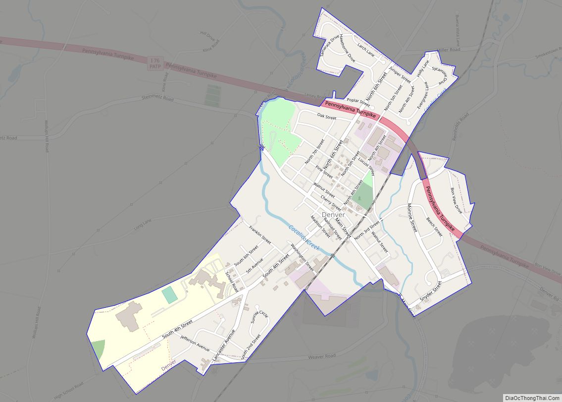
Denver is a borough in Lancaster County, Pennsylvania, United States. The population was 3,794 at the 2020 census, a decline from the figure of 3,861 tabulated in 2010. Denver borough overview: Name: Denver borough LSAD Code: 21 LSAD Description: borough (suffix) State: Pennsylvania County: Lancaster County Elevation: 394 ft (120 m) Total Area: 1.30 sq mi (3.36 km²) Land Area: ... Read more
Map of Denver borough, Pennsylvania
Map of Delta borough, Pennsylvania
Delta is a borough in York County, Pennsylvania, United States, and one of the southernmost communities in Pennsylvania. The population was 706 at the 2020 census. It is served by the South Eastern School District which provides a public education. Delta borough overview: Name: Delta borough LSAD Code: 21 LSAD Description: borough (suffix) State: Pennsylvania ... Read more
Map of Delta borough, Pennsylvania
Map of Donora borough
Donora is a borough in Washington County, Pennsylvania, United States, approximately 20 miles (32 km) south of Pittsburgh on the Monongahela River. Donora was incorporated in 1901. It got its name from a combination of William Donner and Nora Mellon, banker Andrew W. Mellon’s wife. The borough’s nickname is “The Home of Champions”, mainly because of ... Read more
Map of Donora borough
Map of Donegal borough
Donegal is a borough in Westmoreland County, Pennsylvania, United States. It is a distinct municipality from the adjacent Donegal Township. The population was 103 at the 2020 census. Donegal is best known as an exit on the Pennsylvania Turnpike with restaurants, gas stations, and two hotels for travelers. It was named after the town and ... Read more
Map of Donegal borough
Map of Donaldson CDP, Pennsylvania
Donaldson is a census-designated place (CDP) in Frailey Township, Schuylkill County, Pennsylvania, United States. The population was 325 at the 2000 census. Donaldson CDP overview: Name: Donaldson CDP LSAD Code: 57 LSAD Description: CDP (suffix) State: Pennsylvania County: Schuylkill County Total Area: 0.19 sq mi (0.49 km²) Land Area: 0.19 sq mi (0.49 km²) Water Area: 0.00 sq mi (0.00 km²) Total Population: 377 ... Read more
Map of Donaldson CDP, Pennsylvania
Map of Dillsburg borough
Dillsburg is a borough in York County, Pennsylvania, United States. The population was 2,643 as of the 2020 census. Dillsburg borough overview: Name: Dillsburg borough LSAD Code: 21 LSAD Description: borough (suffix) State: Pennsylvania County: York County Incorporated: 1833 Elevation: 659 ft (201 m) Total Area: 0.81 sq mi (2.09 km²) Land Area: 0.81 sq mi (2.09 km²) Water Area: 0.00 sq mi (0.00 km²) Total ... Read more
Map of Dillsburg borough
Map of Dicksonville CDP
Dixonville is an unincorporated community in Indiana County, Pennsylvania, United States. The area is recorded as the “Dicksonville” census-designated place (CDP), with a population of 467 at the 2010 census. The CDP lies mostly on the western edge of Green Township, though a small portion extends west into Rayne Township. Dicksonville CDP overview: Name: Dicksonville ... Read more
Map of Dicksonville CDP
Map of Dickson City borough
Dickson City is a borough in Lackawanna County, Pennsylvania, 4 miles (6 km) north of Scranton. Coal mining was an important industry in the past. The borough’s population peaked at 12,395 in 1930 and was 6,051 at the 2020 census. Dickson City borough overview: Name: Dickson City borough LSAD Code: 21 LSAD Description: borough (suffix) State: ... Read more
Map of Dickson City borough
Map of Dewart CDP
Dewart is a census-designated place located in Delaware Township, Northumberland County in the state of Pennsylvania. The community is located very close to the West Branch Susquehanna River along Pennsylvania Route 405 in far northern Northumberland County. As of the 2010 census the population was 1,471 residents. Dewart CDP overview: Name: Dewart CDP LSAD Code: ... Read more
Map of Dewart CDP
Map of Devon CDP
Devon is a census-designated place (CDP) located in Tredyffrin and Easttown townships in Chester County, Pennsylvania, United States. The population was 1,515 at the 2010 census. The area is part of the Philadelphia Main Line suburbs. Devon CDP overview: Name: Devon CDP LSAD Code: 57 LSAD Description: CDP (suffix) State: Pennsylvania County: Chester County Elevation: ... Read more
Map of Devon CDP
Map of DeSales University CDP
DeSales University (CDP) is a census-designated place located in Upper Saucon Township in Lehigh County, Pennsylvania. As of the 2020 census, the population was 985 residents. DeSales University is part of the Lehigh Valley metropolitan area, which had a population of 861,899 and was the 68th-most populous metropolitan area in the U.S. as of the ... Read more
Map of DeSales University CDP
Map of Derry borough, Pennsylvania
Derry is a borough in Westmoreland County in the Commonwealth of Pennsylvania, United States, 45 miles (72 km) east of Pittsburgh. The Borough of Derry, consisting of the town area, should not be confused with Derry Township, which is a separate municipality surrounding the borough. The population was 2,637 at the 2020 census. Derry borough overview: ... Read more
Map of Derry borough, Pennsylvania