Map of Central Falls city

Map of Central Falls city

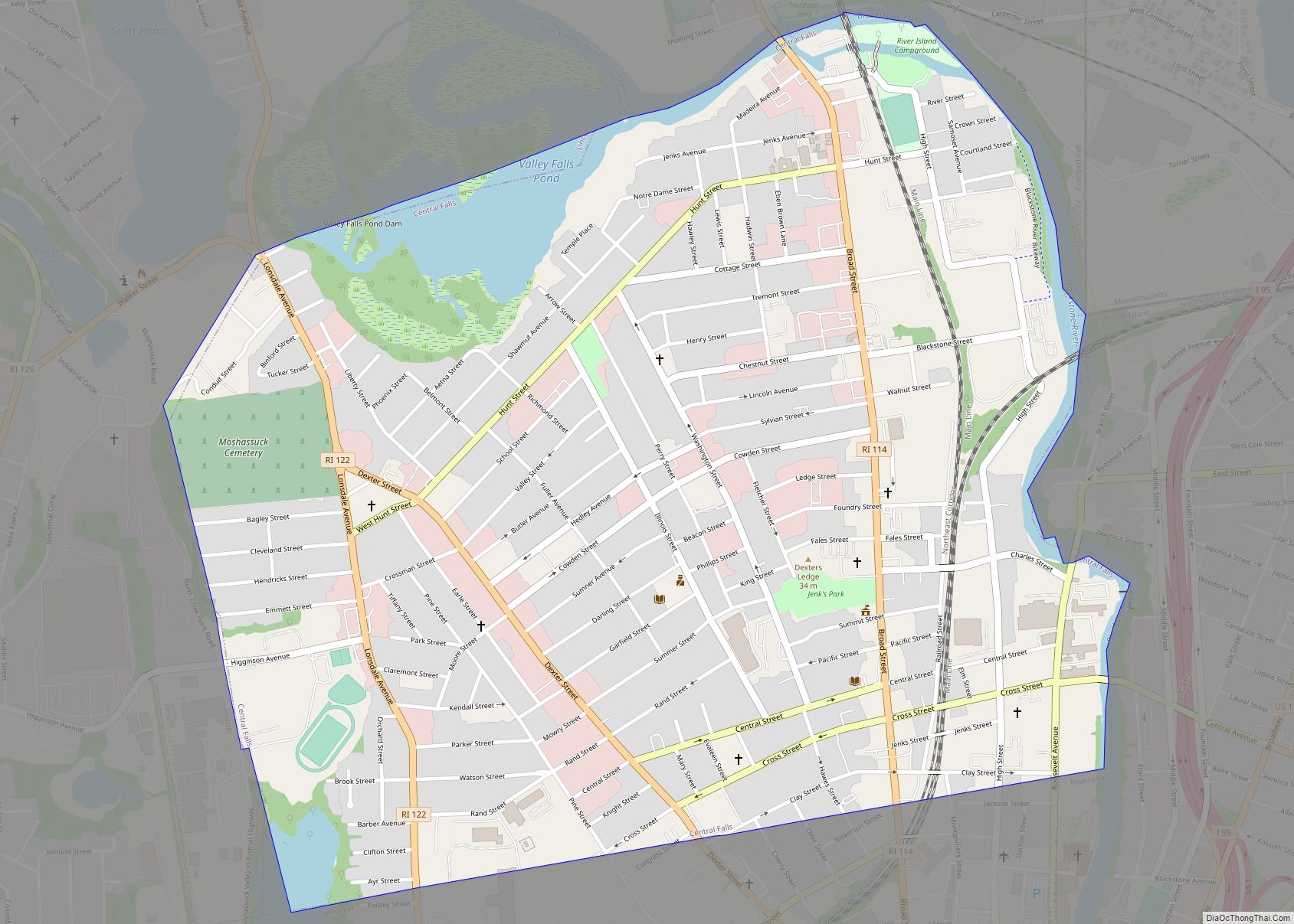
Central Falls is a city in Providence County, Rhode Island, United States. The population was 22,583 at the 2020 census. With an area of only 1.29 square miles (3.3 km), it is the smallest and most densely populated city in the smallest state, and the 27th most densely populated incorporated place in the United States. It … Read more

Map of Carolina CDP, Rhode Island

Map of Carolina CDP, Rhode Island

Carolina is a village that straddles the border of the towns of Charlestown and Richmond on the Pawcatuck River in Washington County, Rhode Island. Rhode Island Route 112 passes through the village. Carolina is identified as a census-designated place, with a population of 970 at the 2010 census. Carolina CDP overview: Name: Carolina CDP LSAD … Read more

Map of Bradford CDP, Rhode Island

Map of Bradford CDP, Rhode Island

Bradford is a census-designated place (CDP) and historic district in the towns of Westerly and Hopkinton in Washington County, Rhode Island, United States. The population was 1,406 at the 2010 census. The Bradford Village Historic District was listed on the National Register of Historic Places in 1996 as a 224-acre (91 ha) area including 149 contributing … Read more

Map of Ashaway CDP

Map of Ashaway CDP

Ashaway (/ˈæʃəweɪ/) is an unincorporated village and census-designated place (CDP) in the town of Hopkinton, Rhode Island, USA. It is a principal village of Hopkinton, along with Hope Valley, although it is the smaller of the two. The population was 1,485 at the 2010 census. The name Ashaway is derived from the American Indian name … Read more

Map of Kingston CDP, Rhode Island

Map of Kingston CDP, Rhode Island

Kingston is a village and a census-designated place within the town of South Kingstown in Washington County, Rhode Island, United States, and the site of the main campus of the University of Rhode Island. The population was 6,974 at the 2010 census. Much of the village center is listed on the National Register of Historic … Read more

Map of Hopkinton CDP, Rhode Island

Map of Hopkinton CDP, Rhode Island

Hopkinton is a census-designated place (CDP) in Washington County, Rhode Island, United States, comprising the central village in the town of Hopkinton. It was first listed as a CDP prior to the 2020 census. The village is also known as Hopkinton City, and the center of the village comprises the Hopkinton City Historic District. Hopkinton … Read more

Map of Hope Valley CDP

Map of Hope Valley CDP

Hope Valley is a village and census-designated place (CDP) in the town of Hopkinton in Washington County, Rhode Island, United States. The population of the CDP was 1,612 at the 2010 census. Hope Valley is the largest village in Hopkinton and the town’s principal commercial center. While the village of Hope Valley is located in … Read more

Map of Harrisville CDP, Rhode Island

Map of Harrisville CDP, Rhode Island

Harrisville is a census-designated place (CDP) and village in the town of Burrillville in Providence County, Rhode Island, United States. The population was 1,605 at the 2010 census. Much of the community composes a historic district listed on the National Register of Historic Places. The village was named after nineteenth century manufacturer Andrew Harris. Previously, … Read more

Map of Harmony CDP, Rhode Island

Map of Harmony CDP, Rhode Island

Harmony is a village and census-designated place in Providence County, Rhode Island, in the town of Glocester, located on U.S. Route 44 (Putnam Pike). As of the 2010 census, it had a population of 985. Harmony CDP overview: Name: Harmony CDP LSAD Code: 57 LSAD Description: CDP (suffix) State: Rhode Island County: Providence County Elevation: … Read more

Map of Greenville CDP, Rhode Island

Map of Greenville CDP, Rhode Island

Greenville is a village and census-designated place (CDP) in the town of Smithfield in Providence County, Rhode Island, United States. The population was 8,658 at the 2010 census. The CDP is centered on the village of Greenville but also encompasses the nearby villages of West Greenville and Spragueville, as well as the Mountaindale Reservoir and … Read more

Map of Newport East CDP

Map of Newport East CDP

Newport East is a census-designated place (CDP) in the town of Middletown, Newport County, Rhode Island, United States. The CDP encompasses the portion of the urban area of the city of Newport that extends beyond the municipal boundaries. The population of the CDP was 11,769 at the 2010 census. Newport East CDP overview: Name: Newport … Read more

Map of Narragansett Pier CDP

Map of Narragansett Pier CDP

Narragansett Pier is an unincorporated village and a census-designated place (CDP) in the town of Narragansett in Washington County, Rhode Island, United States. The population was 3,409 at the 2010 census. Narragansett Pier CDP overview: Name: Narragansett Pier CDP LSAD Code: 57 LSAD Description: CDP (suffix) State: Rhode Island County: Washington County Elevation: 3 ft (1 m) … Read more