Map of Blunt city
Blunt is a city in Hughes County, South Dakota, United States. It is part of the Pierre, South Dakota Micropolitan Statistical Area. The population was 342 at the 2020 census. Blunt city overview: Name: Blunt city LSAD Code: 25 LSAD Description: city (suffix) State: South Dakota County: Hughes County Elevation: 1,621 ft (494 m) Total Area: 0.49 sq mi ... Read more
Map of Blunt city
Map of Blucksberg Mountain CDP
Blucksberg Mountain is an unincorporated community and census-designated place in Meade County, South Dakota, United States. Its population was 467 as of the 2020 census. Interstate 90 passes through the community. Blucksberg Mountain CDP overview: Name: Blucksberg Mountain CDP LSAD Code: 57 LSAD Description: CDP (suffix) State: South Dakota County: Meade County Elevation: 3,891 ft (1,186 m) ... Read more
Map of Blucksberg Mountain CDP
Map of Blackhawk CDP, South Dakota
Black Hawk (sometimes Blackhawk) is an unincorporated census-designated place (CDP) in Meade County, South Dakota, United States. The population was 3,026 at the 2020 census. Black Hawk has been assigned the ZIP code of 57718. Located along Interstate 90, Black Hawk is part of the Rapid City metropolitan area. Blackhawk CDP overview: Name: Blackhawk CDP ... Read more
Map of Blackhawk CDP, South Dakota
Map of Bison town, South Dakota
Bison is a town in and the county seat of Perkins County, South Dakota, United States. The population was 302 at the 2020 census. Bison town overview: Name: Bison town LSAD Code: 43 LSAD Description: town (suffix) State: South Dakota County: Perkins County Elevation: 2,782 ft (848 m) Total Area: 0.99 sq mi (2.57 km²) Land Area: 0.99 sq mi (2.57 km²) Water ... Read more
Map of Bison town, South Dakota
Map of Bijou Hills CDP
Bijou Hills (Lakota: Wíyukeze Pahá) is an unincorporated community and census-designated place in Brule County, South Dakota, United States. The population was 2 according to the 2020 census. The CDP is located in southern Brule County, at the south base of a small ridge known as the Bijou Hills. The community is 1.2 miles (1.9 km) ... Read more
Map of Bijou Hills CDP
Map of Big Stone City
Big Stone City is a city in the northeastern corner of Grant County, South Dakota, United States, that lies between the southern tip of Big Stone Lake and the northern bank of the Whetstone River, and is adjacent to the city of Ortonville, Minnesota. The population was 412 at the 2020 census. Big Stone City ... Read more
Map of Big Stone City
Map of Beresford city
Beresford (/ˈbɪərzfərd/; BEERZ-fərd) is a city in Lincoln and Union counties in the U.S. state of South Dakota. The population was 2,180 as of the 2020 census. The southern two-thirds is part of the Sioux City, IA–NE-SD Metropolitan Statistical Area, while the northern one-third is part of the Sioux Falls Metropolitan Statistical Area. The Beresford ... Read more
Map of Beresford city
Map of Box Elder city, South Dakota
Box Elder (Lakota: čhaŋšúška; “box elder maple”) is a city in Pennington and Meade counties in the State of South Dakota. The population was 11,746 according to the 2020 census, making it the 11th most populous city in South Dakota. Ellsworth Air Force Base lies on the northeast side of the city. Box Elder was ... Read more
Map of Box Elder city, South Dakota
Map of Bowdle city
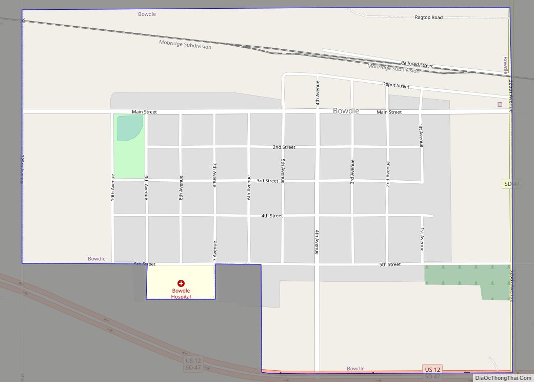
Bowdle (/ˈbaʊdəl/ is a city in Edmunds County, South Dakota, United States. The population was 470 at the 2020 census. Bowdle city overview: Name: Bowdle city LSAD Code: 25 LSAD Description: city (suffix) State: South Dakota County: Edmunds County Incorporated: 1911 Elevation: 1,998 ft (609 m) Total Area: 0.64 sq mi (1.66 km²) Land Area: 0.64 sq mi (1.66 km²) Water Area: 0.00 sq mi ... Read more
Map of Bowdle city
Map of Broadland town
Broadland is a town in Beadle County, South Dakota, United States. The population was 27 at the 2020 census. Broadland town overview: Name: Broadland town LSAD Code: 43 LSAD Description: town (suffix) State: South Dakota County: Beadle County Incorporated: 1911 Elevation: 1,306 ft (398 m) Total Area: 1.01 sq mi (2.61 km²) Land Area: 1.01 sq mi (2.61 km²) Water Area: 0.00 sq mi (0.00 km²) ... Read more
Map of Broadland town
Map of Britton city, South Dakota
Britton is a city in and the county seat of Marshall County, South Dakota, United States. The population was 1,215 at the 2020 census. A weekly newspaper, the Britton Journal, is published in Britton. Britton city overview: Name: Britton city LSAD Code: 25 LSAD Description: city (suffix) State: South Dakota County: Marshall County Incorporated: 1883 ... Read more
Map of Britton city, South Dakota
Map of Bristol city, South Dakota
Bristol is a city located in western Day County, South Dakota, United States. It lies in Section 25 of Bristol Township, on the main line of what is now the BNSF Railway alongside U.S. Route 12. The population was 288 at the 2020 census.` Similar to many towns of the area and of the Midwest ... Read more
Map of Bristol city, South Dakota