Map of Bardwell city, Texas

Map of Bardwell city, Texas

Bardwell is a city in Ellis County, in the U.S. state of Texas. The population was 649 at the 2010 census. Bardwell city overview: Name: Bardwell city LSAD Code: 25 LSAD Description: city (suffix) State: Texas County: Ellis County Elevation: 482 ft (147 m) Total Area: 0.30 sq mi (0.79 km²) Land Area: 0.30 sq mi (0.79 km²) Water Area: 0.00 sq mi (0.00 km²) Total … Read more

Map of Banquete CDP

Map of Banquete CDP

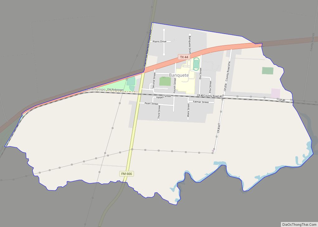
Banquete (/bæŋˈkɛti/ bang-KET-ee) is a census-designated place (CDP) in Nueces County, Texas, United States. Banquete is located at the intersection of State Highway 44 and FM 666, 23 miles west of Corpus Christi. Banquete should not be confused with Rancho Banquete, a census-designated place situated several miles west of the community. Banquete is a new … Read more

Map of Bangs city

Map of Bangs city

Bangs is a city located in Brown County in west-central Texas, in the United States. The population was 1,603 at the 2010 census. Bangs city overview: Name: Bangs city LSAD Code: 25 LSAD Description: city (suffix) State: Texas County: Brown County Elevation: 1,608 ft (490 m) Total Area: 1.50 sq mi (3.88 km²) Land Area: 1.50 sq mi (3.88 km²) Water Area: 0.00 sq mi … Read more

Map of Bandera city

Map of Bandera city

Bandera (Spanish: “flag”, /bænˈdɛrə/ ban-DERR-ə) is the county seat of Bandera County, Texas, United States, in the Texas Hill Country, which is part of the Edwards Plateau. The population was 829 at the 2020 census. Bandera calls itself the “Cowboy Capital of the World”. Bandera city overview: Name: Bandera city LSAD Code: 25 LSAD Description: … Read more

Map of Balmorhea city

Map of Balmorhea city

Balmorhea (/ˌbælməˈreɪ/ BAL-mə-RAY) is a city in Reeves County, in the U.S. state of Texas. The population was 479 in the U.S. Census of 2010. Balmorhea city overview: Name: Balmorhea city LSAD Code: 25 LSAD Description: city (suffix) State: Texas County: Reeves County Elevation: 3,196 ft (974 m) Total Area: 0.39 sq mi (1.00 km²) Land Area: 0.39 sq mi (1.00 km²) Water … Read more

Map of Ballinger city

Map of Ballinger city

Ballinger (/ˈbælɪndʒər/ BAL-in-jər) is a city in Runnels County, Texas, United States. The population was 3,767 at the 2010 census. It is the county seat of Runnels County. Downtown Ballinger features historic 1800s buildings with shops and restaurants. Ballinger city overview: Name: Ballinger city LSAD Code: 25 LSAD Description: city (suffix) State: Texas County: Runnels … Read more

Map of Balcones Heights city

Map of Balcones Heights city

Balcones Heights is a city in Bexar County, Texas, United States. Its population was 2,746 at the 2020 census, and it was incorporated in 1948. Balcones Heights is an enclave of San Antonio, surrounded entirely by the city, thus some residents and out-of-town visitors erroneously consider it merely a neighborhood of the larger city rather … Read more

Map of Balch Springs city

Map of Balch Springs city

Balch Springs (/bɑːlk/ BAHLK, /bɑːltʃ/ BAHLTCH) is a city in Dallas County, Texas, United States. It is an inner-ring suburb of Dallas and part of the Dallas–Fort Worth metroplex. Its population was 23,728 at the 2010 census, and 25,007 at 2019’s census estimates. Balch Springs city overview: Name: Balch Springs city LSAD Code: 25 LSAD … Read more

Map of Baird city

Map of Baird city

Baird is a city and the county seat of Callahan County, Texas, United States. Its population was 1,496 at the 2010 census. The city is named after Matthew Baird, the owner and director of the Texas and Pacific Railway. The railway depot is now operated as the visitor center and a transportation museum. Baird is … Read more

Map of Bailey city, Texas

Map of Bailey city, Texas

Bailey is a city in Fannin County, in the U.S. state of Texas. The population was 289 at the 2010 census, up from 213 at the 2000 census. Bailey city overview: Name: Bailey city LSAD Code: 25 LSAD Description: city (suffix) State: Texas County: Fannin County Elevation: 712 ft (217 m) Total Area: 0.40 sq mi (1.03 km²) Land Area: … Read more

Map of Barton Creek CDP

Map of Barton Creek CDP

Barton Creek is a census-designated place (CDP) in Travis County, Texas, United States. As of the 2010 census, the CDP population was 3,077. Barton Creek is ranked second in Texas based on per capita income. Barton Creek CDP overview: Name: Barton Creek CDP LSAD Code: 57 LSAD Description: CDP (suffix) State: Texas County: Travis County … Read more

Map of Bartlett city, Texas

Map of Bartlett city, Texas

Bartlett is a city in Bell and Williamson counties in the U.S. state of Texas. The population was 1,633 at the 2020 census. Bartlett lies in two counties as well as two metropolitan areas. The Bell County portion of the city is part of the Killeen–Temple–Fort Hood Metropolitan Statistical Area, while the Williamson County portion … Read more