Balch Springs (/bɑːlk/ BAHLK, /bɑːltʃ/ BAHLTCH) is a city in Dallas County, Texas, United States. It is an inner-ring suburb of Dallas and part of the Dallas–Fort Worth metroplex. Its population was 23,728 at the 2010 census, and 25,007 at 2019’s census estimates.
| Name: | Balch Springs city |
|---|---|
| LSAD Code: | 25 |
| LSAD Description: | city (suffix) |
| State: | Texas |
| County: | Dallas County |
| Incorporated: | June 13, 1953 |
| Elevation: | 499 ft (152 m) |
| Total Area: | 9.04 sq mi (23.42 km²) |
| Land Area: | 9.02 sq mi (23.37 km²) |
| Water Area: | 0.02 sq mi (0.05 km²) 0.27% |
| Total Population: | 23,728+ |
| Population Density: | 2,771.17/sq mi (1,069.90/km²) |
| ZIP code: | 75180 |
| FIPS code: | 4805372 |
| GNISfeature ID: | 1329964 |
| Website: | cityofbalchsprings.com |
Online Interactive Map
Click on ![]() to view map in "full screen" mode.
to view map in "full screen" mode.
Balch Springs location map. Where is Balch Springs city?


History
The area was first settled in the 1840s. Around 1879, John M. Balch and his family settled south of Mesquite in unincorporated Dallas County. Mr. Balch found several springs on his land, one of which ran year-round. Local residents began referring to the springs on Mr. Balch’s property as Balch Springs, and use of the name continued even after he moved away a few years after his arrival. Around 1885, a county school was named after the springs. A small church and a cemetery were near the school. During the early 1900s, the community was widely dispersed and consisted mostly of farms. Electricity, provided by Texas Power and Light, was introduced in 1939. Gas and telephone service arrived shortly after World War II.
The community began to grow rapidly along with the city of Dallas and other Dallas County towns. To avoid annexation by Dallas, Balch Springs incorporated as a city on June 13, 1953. The new city encompassed the communities of Balch Springs, Zipp City, Five Points, Jonesville, and Triangle, as well as portions of Rylie and Kleberg. A mayor-council form of government was adopted after incorporation. By 1956, Balch Springs had a population around 3,500. The city was home to 6,821 residents at the 1960 census. In September 1964, a post office opened in the city and in 1965, the first taxes were levied. A 1966 attempt to disincorporate the community was unsuccessful. By 1970, the population had risen to 10,464 as the construction of new roads made commuting to surrounding cities easier. In 1988, residents voted to become part of the neighboring city of Mesquite, but the election was declared invalid. Two years later, the 1990 census reported a total of 17,406 people living in the city. The 2000 population was 19,375.
The murder of Jordan Edwards occurred in Balch Springs in 2017.
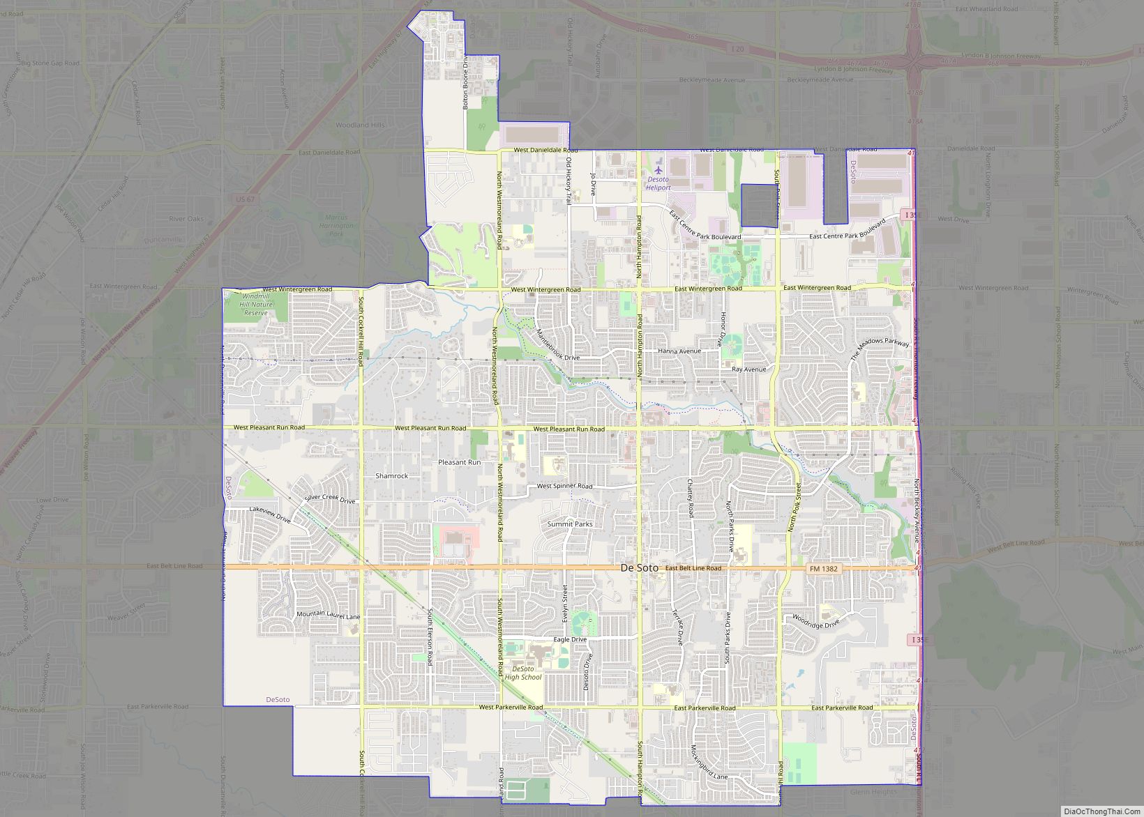
Balch Springs Road Map

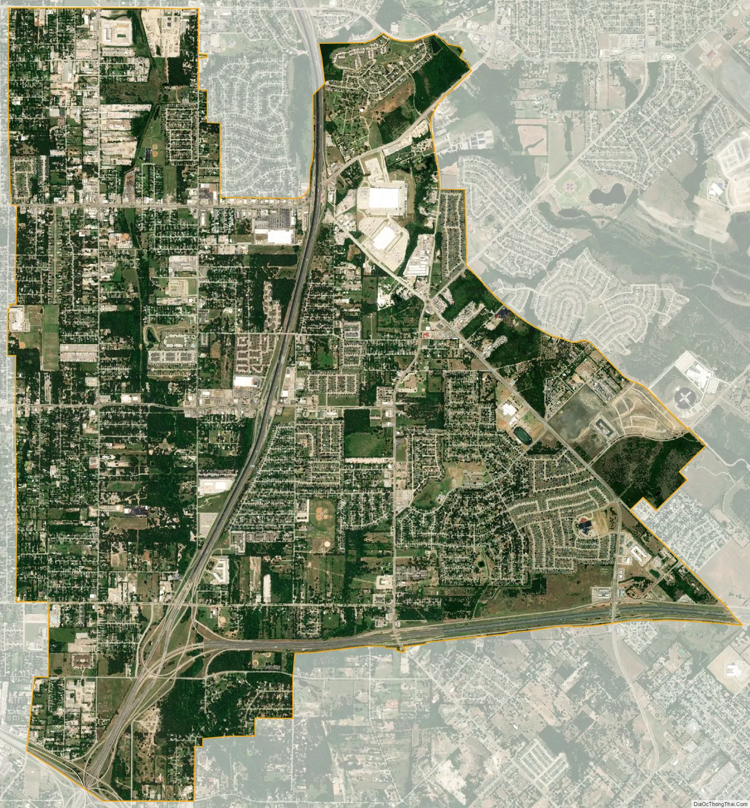
Balch Springs city Satellite Map
Geography
Balch Springs is located at 32°43′3″N 96°36′55″W / 32.71750°N 96.61528°W / 32.71750; -96.61528 (32.717381, –96.615154). It is situated about 16 miles (26 km) east of downtown Dallas and 34 miles (55 km) southeast of the Dallas/Fort Worth International Airport. The city is bordered by Mesquite to the north and east, and Dallas to the south and west.
Major highways running through Balch Springs include Interstate 635, which bisects the city into two nearly equal halves. Interstate 20 and U.S. Highway 175 run along Balch Springs’ southern border.
According to the United States Census Bureau, the city has a total area of 9.0 square miles (23.3 km), of which 0.02 square miles (0.06 km), or 0.27%, is covered by water.
See also
Map of Texas State and its subdivision:- Anderson
- Andrews
- Angelina
- Aransas
- Archer
- Armstrong
- Atascosa
- Austin
- Bailey
- Bandera
- Bastrop
- Baylor
- Bee
- Bell
- Bexar
- Blanco
- Borden
- Bosque
- Bowie
- Brazoria
- Brazos
- Brewster
- Briscoe
- Brooks
- Brown
- Burleson
- Burnet
- Caldwell
- Calhoun
- Callahan
- Cameron
- Camp
- Carson
- Cass
- Castro
- Chambers
- Cherokee
- Childress
- Clay
- Cochran
- Coke
- Coleman
- Collin
- Collingsworth
- Colorado
- Comal
- Comanche
- Concho
- Cooke
- Coryell
- Cottle
- Crane
- Crockett
- Crosby
- Culberson
- Dallam
- Dallas
- Dawson
- Deaf Smith
- Delta
- Denton
- Dewitt
- Dickens
- Dimmit
- Donley
- Duval
- Eastland
- Ector
- Edwards
- El Paso
- Ellis
- Erath
- Falls
- Fannin
- Fayette
- Fisher
- Floyd
- Foard
- Fort Bend
- Franklin
- Freestone
- Frio
- Gaines
- Galveston
- Garza
- Gillespie
- Glasscock
- Goliad
- Gonzales
- Gray
- Grayson
- Gregg
- Grimes
- Guadalupe
- Hale
- Hall
- Hamilton
- Hansford
- Hardeman
- Hardin
- Harris
- Harrison
- Hartley
- Haskell
- Hays
- Hemphill
- Henderson
- Hidalgo
- Hill
- Hockley
- Hood
- Hopkins
- Houston
- Howard
- Hudspeth
- Hunt
- Hutchinson
- Irion
- Jack
- Jackson
- Jasper
- Jeff Davis
- Jefferson
- Jim Hogg
- Jim Wells
- Johnson
- Jones
- Karnes
- Kaufman
- Kendall
- Kenedy
- Kent
- Kerr
- Kimble
- King
- Kinney
- Kleberg
- Knox
- La Salle
- Lamar
- Lamb
- Lampasas
- Lavaca
- Lee
- Leon
- Liberty
- Limestone
- Lipscomb
- Live Oak
- Llano
- Loving
- Lubbock
- Lynn
- Madison
- Marion
- Martin
- Mason
- Matagorda
- Maverick
- McCulloch
- McLennan
- McMullen
- Medina
- Menard
- Midland
- Milam
- Mills
- Mitchell
- Montague
- Montgomery
- Moore
- Morris
- Motley
- Nacogdoches
- Navarro
- Newton
- Nolan
- Nueces
- Ochiltree
- Oldham
- Orange
- Palo Pinto
- Panola
- Parker
- Parmer
- Pecos
- Polk
- Potter
- Presidio
- Rains
- Randall
- Reagan
- Real
- Red River
- Reeves
- Refugio
- Roberts
- Robertson
- Rockwall
- Runnels
- Rusk
- Sabine
- San Augustine
- San Jacinto
- San Patricio
- San Saba
- Schleicher
- Scurry
- Shackelford
- Shelby
- Sherman
- Smith
- Somervell
- Starr
- Stephens
- Sterling
- Stonewall
- Sutton
- Swisher
- Tarrant
- Taylor
- Terrell
- Terry
- Throckmorton
- Titus
- Tom Green
- Travis
- Trinity
- Tyler
- Upshur
- Upton
- Uvalde
- Val Verde
- Van Zandt
- Victoria
- Walker
- Waller
- Ward
- Washington
- Webb
- Wharton
- Wheeler
- Wichita
- Wilbarger
- Willacy
- Williamson
- Wilson
- Winkler
- Wise
- Wood
- Yoakum
- Young
- Zapata
- Zavala
- Alabama
- Alaska
- Arizona
- Arkansas
- California
- Colorado
- Connecticut
- Delaware
- District of Columbia
- Florida
- Georgia
- Hawaii
- Idaho
- Illinois
- Indiana
- Iowa
- Kansas
- Kentucky
- Louisiana
- Maine
- Maryland
- Massachusetts
- Michigan
- Minnesota
- Mississippi
- Missouri
- Montana
- Nebraska
- Nevada
- New Hampshire
- New Jersey
- New Mexico
- New York
- North Carolina
- North Dakota
- Ohio
- Oklahoma
- Oregon
- Pennsylvania
- Rhode Island
- South Carolina
- South Dakota
- Tennessee
- Texas
- Utah
- Vermont
- Virginia
- Washington
- West Virginia
- Wisconsin
- Wyoming