Map of Batesville CDP, Texas

Map of Batesville CDP, Texas

Batesville is a census-designated place (CDP) in Zavala County, Texas, United States. The population was 1,068 at the 2010 census. Batesville CDP overview: Name: Batesville CDP LSAD Code: 57 LSAD Description: CDP (suffix) State: Texas County: Zavala County Elevation: 705 ft (215 m) Total Area: 5.9 sq mi (15 km²) Land Area: 5.9 sq mi (15 km²) Water Area: 0.0 sq mi (0 km²) Total Population: … Read more

Map of Bastrop city, Texas

Map of Bastrop city, Texas

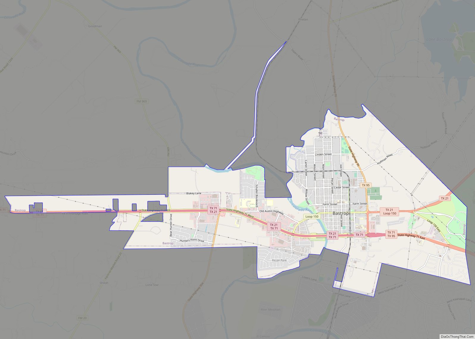
Bastrop (/ˈbæstrəp, -trɒp/) is a city and the county seat of Bastrop County, Texas, United States. The population was 9,688 according to the 2020 census. It is located about 30 mi (48 km) southeast of Austin and is part of the Greater Austin metropolitan area. Bastrop city overview: Name: Bastrop city LSAD Code: 25 LSAD Description: city … Read more

Map of Bartonville town, Texas

Map of Bartonville town, Texas

Bartonville is a town in Denton County, Texas, United States. The population was 1,469 at the 2010 census. Bartonville town overview: Name: Bartonville town LSAD Code: 43 LSAD Description: town (suffix) State: Texas County: Denton County Elevation: 679 ft (207 m) Total Area: 6.89 sq mi (17.84 km²) Land Area: 6.83 sq mi (17.70 km²) Water Area: 0.06 sq mi (0.15 km²) Total Population: 1,469 Population … Read more

Map of Barton Creek CDP

Map of Barton Creek CDP

Barton Creek is a census-designated place (CDP) in Travis County, Texas, United States. As of the 2010 census, the CDP population was 3,077. Barton Creek is ranked second in Texas based on per capita income. Barton Creek CDP overview: Name: Barton Creek CDP LSAD Code: 57 LSAD Description: CDP (suffix) State: Texas County: Travis County … Read more

Map of Bartlett city, Texas

Map of Bartlett city, Texas

Bartlett is a city in Bell and Williamson counties in the U.S. state of Texas. The population was 1,633 at the 2020 census. Bartlett lies in two counties as well as two metropolitan areas. The Bell County portion of the city is part of the Killeen–Temple–Fort Hood Metropolitan Statistical Area, while the Williamson County portion … Read more

Map of Barstow city, Texas

Map of Barstow city, Texas

Barstow is a city in Ward County, in the U.S. state of Texas. The population was 349 at the 2010 census. Barstow city overview: Name: Barstow city LSAD Code: 25 LSAD Description: city (suffix) State: Texas County: Ward County Elevation: 2,566 ft (782 m) Total Area: 0.66 sq mi (1.70 km²) Land Area: 0.66 sq mi (1.70 km²) Water Area: 0.00 sq mi (0.00 km²) Total … Read more

Map of Barry city, Texas

Map of Barry city, Texas

Barry is a city in Navarro County, in the U.S. state of Texas. The population was 242 at the 2010 census. Barry city overview: Name: Barry city LSAD Code: 25 LSAD Description: city (suffix) State: Texas County: Navarro County Elevation: 499 ft (152 m) Total Area: 0.45 sq mi (1.16 km²) Land Area: 0.44 sq mi (1.14 km²) Water Area: 0.01 sq mi (0.02 km²) Total … Read more

Map of Barrett CDP, Texas

Map of Barrett CDP, Texas

Barrett, also named Barrett Station, is an unincorporated community and census-designated place (CDP) in Harris County, Texas, United States. The population was 5,223 at the 2020 census. It was founded in 1889 by Harrison Barrett, a former slave. Barrett CDP overview: Name: Barrett CDP LSAD Code: 57 LSAD Description: CDP (suffix) State: Texas County: Harris … Read more

Map of Beasley city

Map of Beasley city

Beasley is a city in Fort Bend County, Texas, United States, within the Houston–Sugar Land metropolitan area. The city’s population was 641 at the 2010 census, up from 590 at the 2000 census. State Highway Loop 540 goes straight through the city from the northeast to the southwest while U.S. Route 59, the Southwest Freeway, passes … Read more

Map of Bear Creek village, Texas

Map of Bear Creek village, Texas

Bear Creek is a village in Hays County, Texas, United States. The population was 382 at the 2010 census. Bear Creek village overview: Name: Bear Creek village LSAD Code: 47 LSAD Description: village (suffix) State: Texas County: Hays County Elevation: 991 ft (302 m) Total Area: 1.14 sq mi (2.96 km²) Land Area: 1.14 sq mi (2.96 km²) Water Area: 0.00 sq mi (0.00 km²) Total … Read more

Map of Beach City, Texas

Map of Beach City, Texas

Beach City is a U.S. city in Chambers County, Texas. The population was 3,221 at the 2020 census. It can now be considered as a part of Greater Houston. Beach City city overview: Name: Beach City city LSAD Code: 25 LSAD Description: city (suffix) State: Texas County: Chambers County Elevation: 23 ft (7 m) Total Area: 4.48 sq mi … Read more

Map of Bayview town, Texas

Map of Bayview town, Texas

Bayview is a town in Cameron County, Texas, United States. The population was 383 at the 2010 census. It is part of the Brownsville–Harlingen–Raymondville and the Matamoros–Brownsville metropolitan areas. Bayview town overview: Name: Bayview town LSAD Code: 43 LSAD Description: town (suffix) State: Texas County: Cameron County Elevation: 26 ft (8 m) Total Area: 4.61 sq mi (11.95 km²) Land … Read more