Map of Roanoke city, Texas
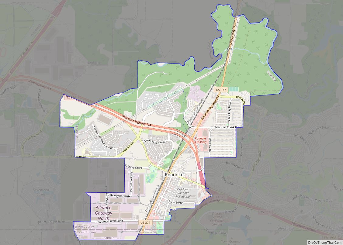
Roanoke is a city in Denton County, Texas, United States and part of the Dallas–Fort Worth Metroplex. The population was 5,962 at the 2010 census. With a 2020 population of 10,537, it is the 236th largest city in Texas and the 2991st largest city in the United States. Roanoke is currently growing at a rate ... Read more
Map of Roanoke city, Texas
Map of Riviera CDP
Riviera is a census-designated place and unincorporated community in Kleberg County, Texas, United States. As of the 2010 census it had a population of 689. It is located 15 miles (24 km) south of Kingsville on U.S. Route 77 (Future Interstate 69E) and 22 miles (35 km) northeast of Falfurrias on Texas State Highway 285. Riviera CDP ... Read more
Map of Riviera CDP
Map of Riverside city, Texas
Riverside is a small city in Walker County, Texas, United States. The population was 522 at the 2020 census. Two famous natives of Riverside are the singer-actress Jennifer Holliday (born 1960), who is best known for her creation of the role of Effie in the successful Tony-award-winning Broadway musical “Dreamgirls”, and Eugene C. Barker, a ... Read more
Map of Riverside city, Texas
Map of Rivereno CDP
Rivereno is a census-designated place (CDP) in Starr County, Texas, United States. This was a new CDP for the 2010 census with a population of 61. Rivereno CDP overview: Name: Rivereno CDP LSAD Code: 57 LSAD Description: CDP (suffix) State: Texas County: Starr County Total Area: 61 FIPS code: 4862318 Online Interactive Map Rivereno online ... Read more
Map of Rivereno CDP
Map of River Oaks city
River Oaks is a city in Tarrant County, Texas, United States. Its population was 7,427 at the 2010 census. River Oaks city overview: Name: River Oaks city LSAD Code: 25 LSAD Description: city (suffix) State: Texas County: Tarrant County Elevation: 600 ft (183 m) Total Area: 2.02 sq mi (5.23 km²) Land Area: 2.02 sq mi (5.23 km²) Water Area: 0.00 sq mi (0.00 km²) Total ... Read more
Map of River Oaks city
Map of Rising Star town
Rising Star is a town in Eastland County, Texas, United States. Its population as of the 2010 census was 835. Rising Star town overview: Name: Rising Star town LSAD Code: 43 LSAD Description: town (suffix) State: Texas County: Eastland County Elevation: 1,624 ft (495 m) Total Area: 1.73 sq mi (4.47 km²) Land Area: 1.73 sq mi (4.47 km²) Water Area: 0.00 sq mi (0.00 km²) ... Read more
Map of Rising Star town
Map of Rio Vista city, Texas
Rio Vista is a city in Johnson County, Texas, United States. The population was 1,008 in 2020. Rio Vista city overview: Name: Rio Vista city LSAD Code: 25 LSAD Description: city (suffix) State: Texas County: Johnson County Elevation: 732 ft (223 m) Total Area: 1.06 sq mi (2.74 km²) Land Area: 1.05 sq mi (2.73 km²) Water Area: 0.00 sq mi (0.01 km²) Total Population: 873 ... Read more
Map of Rio Vista city, Texas
Map of Rio Hondo city
Rio Hondo is a city in Cameron County, Texas, United States. The population was 2,356 at the 2010 census. It may be included as part of the Brownsville–Harlingen–Raymondville and the Matamoros–Brownsville metropolitan areas. Rio Hondo city overview: Name: Rio Hondo city LSAD Code: 25 LSAD Description: city (suffix) State: Texas County: Cameron County Elevation: 26 ft ... Read more
Map of Rio Hondo city
Map of Rochester town, Texas
Rochester is a town in northwestern Haskell County, Texas, United States. The population was 324 at the 2010 census, down from 378 as of the 2000 census. Rochester town overview: Name: Rochester town LSAD Code: 43 LSAD Description: town (suffix) State: Texas County: Haskell County Founded: 1906; 117 years ago (1906) Elevation: 1,594 ft (486 m) Total Area: 0.34 sq mi ... Read more
Map of Rochester town, Texas
Map of Roby city
Roby is a city in and the county seat of Fisher County, Texas, United States. The population was 643 at the 2010 census. Roby city overview: Name: Roby city LSAD Code: 25 LSAD Description: city (suffix) State: Texas County: Fisher County Elevation: 1,962 ft (598 m) Total Area: 0.72 sq mi (1.86 km²) Land Area: 0.72 sq mi (1.86 km²) Water Area: 0.00 sq mi ... Read more
Map of Roby city
Map of Robstown city
Robstown is a city in Nueces County, Texas, United States, and a western suburb of Corpus Christi. It was founded about 1906, and was named for Robert Driscoll. The population was 11,487 as of the 2010 census. The Texas State Legislature officially recognizes Robstown as the birthplace of Texas hold ’em poker. Robstown city overview: ... Read more
Map of Robstown city
Map of Robinson city, Texas
Robinson is a city in McLennan County, Texas, United States. The population was 12,443 at the 2020 census. It is part of the Waco Metropolitan Statistical Area. Robinson city overview: Name: Robinson city LSAD Code: 25 LSAD Description: city (suffix) State: Texas County: McLennan County Elevation: 495 ft (151 m) Total Area: 31.58 sq mi (81.80 km²) Land Area: 31.25 sq mi ... Read more
Map of Robinson city, Texas