Map of Stafford city, Texas

Map of Stafford city, Texas

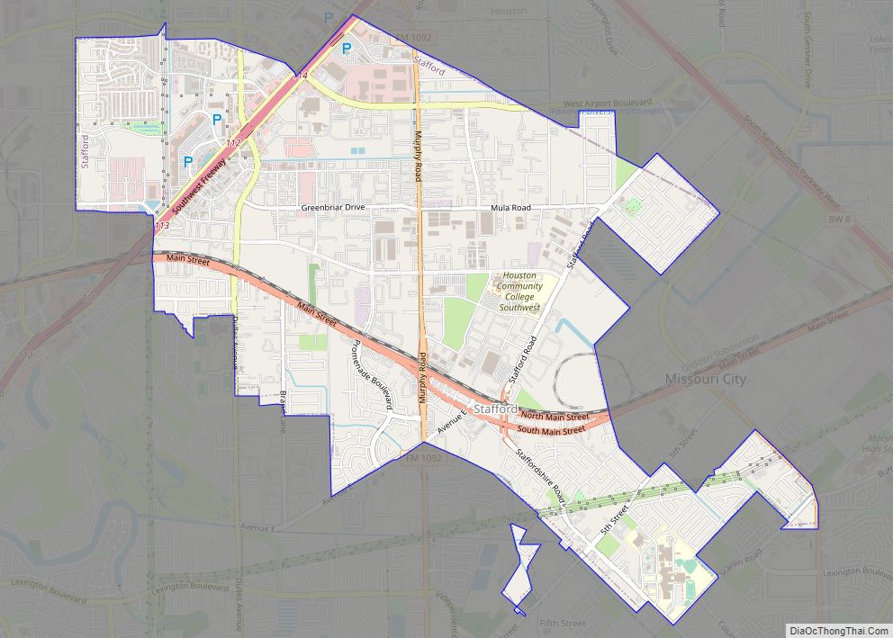
Stafford is a city in the U.S. state of Texas, in the Houston–The Woodlands–Sugar Land metropolitan area. The city is mostly in Fort Bend County, with a small part in Harris County. As of the 2020 census, Stafford’s population was 17,666, down from 17,693 at the 2010 census. Stafford city overview: Name: Stafford city LSAD … Read more

Map of St. Paul CDP, Texas

Map of St. Paul CDP, Texas

St. Paul is a census-designated place (CDP) in San Patricio County, Texas, United States. The population was 584 at the 2010 census. St. Paul CDP overview: Name: St. Paul CDP LSAD Code: 57 LSAD Description: CDP (suffix) State: Texas County: San Patricio County Total Area: 3.3 sq mi (9 km²) Land Area: 3.3 sq mi (9 km²) Water Area: 0.0 sq mi (0 km²) … Read more

Map of St. Jo city

Map of St. Jo city

Saint Jo is a city in Montague County, Texas, United States, along the northern border of the state. The population was 1,043 at the 2010 census. St. Jo city overview: Name: St. Jo city LSAD Code: 25 LSAD Description: city (suffix) State: Texas County: Montague County Elevation: 1,142 ft (348 m) Total Area: 1.08 sq mi (2.79 km²) Land Area: … Read more

Map of St. Hedwig town

Map of St. Hedwig town

St. Hedwig is a town in Bexar County, Texas, United States. The population was 2,227 at the 2020 census. It is part of the San Antonio Metropolitan Statistical Area. St. Hedwig town overview: Name: St. Hedwig town LSAD Code: 43 LSAD Description: town (suffix) State: Texas County: Bexar County Elevation: 577 ft (176 m) Total Area: 29.90 sq mi … Read more

Map of Spur city

Map of Spur city

Spur is a city in Dickens County, Texas, United States. The population was 1,318 at the 2010 census, up from 1,088 at the 2000 census. A city council resolution passed July 2014 proclaimed Spur the “nation’s first tiny house-friendly town.” Spur city overview: Name: Spur city LSAD Code: 25 LSAD Description: city (suffix) State: Texas … Read more

Map of Springtown city, Texas

Map of Springtown city, Texas

Springtown is a town in Parker County and Wise County, Texas, United States. According to the 2020 census, the population was 3,064. Springtown city overview: Name: Springtown city LSAD Code: 25 LSAD Description: city (suffix) State: Texas County: Parker County, Wise County Elevation: 860 ft (260 m) Total Area: 3.04 sq mi (7.86 km²) Land Area: 3.04 sq mi (7.86 km²) Water Area: … Read more

Map of Springlake town

Map of Springlake town

Springlake is a town in Lamb County, Texas, United States. The population was 108 at the 2010 census. The community is known for its agricultural processing and its yearly Independence Day parade and celebration culminating in a fireworks display headed by the Springlake Volunteer Fire Department. This celebration usually draws several thousand participants who come … Read more

Map of Spring CDP

Map of Spring CDP

Spring is a census-designated place (CDP) within the extraterritorial jurisdiction of Houston in Harris County, Texas, United States, part of the Houston–The Woodlands–Sugar Land metropolitan area. The population was 62,559 at the 2020 census. While the name “Spring” is popularly applied to a large area of northern Harris County and a smaller area of southern … Read more

Map of Spring Valley Village city

Map of Spring Valley Village city

Spring Valley Village is a city in Harris County, Texas, United States, and an enclave of Houston. The population was 4,229 at the 2020 U.S. census. Spring Valley Village city overview: Name: Spring Valley Village city LSAD Code: 25 LSAD Description: city (suffix) State: Texas County: Harris County Elevation: 75 ft (23 m) Total Area: 1.22 sq mi (3.15 km²) … Read more

Map of Spring Gardens CDP

Map of Spring Gardens CDP

Spring Gardens is a census-designated place (CDP) in Nueces County, Texas, United States. The population was 563 at the 2010 census. Prior to the 2010 census Spring Gardens was part of the Spring Garden-Terra Verde CDP. Spring Gardens CDP overview: Name: Spring Gardens CDP LSAD Code: 57 LSAD Description: CDP (suffix) State: Texas County: Nueces … Read more

Map of Stamford city, Texas

Map of Stamford city, Texas

Stamford is a city on the border of Jones and Haskell Counties in west-central Texas. The population was 3,124 at the 2010 census, down from 3,636 at the 2000 census. Henry McHarg, president of the Texas Central Railroad, named the site in 1900 for his hometown of Stamford, Connecticut. The city is home to the … Read more

Map of Stagecoach town, Texas

Map of Stagecoach town, Texas

Stagecoach is a town in Montgomery County, Texas, United States. The population was 538 at the 2010 census. Stagecoach town overview: Name: Stagecoach town LSAD Code: 43 LSAD Description: town (suffix) State: Texas County: Montgomery County Elevation: 194 ft (59 m) Total Area: 1.18 sq mi (3.05 km²) Land Area: 1.15 sq mi (2.98 km²) Water Area: 0.03 sq mi (0.07 km²) Total Population: 538 Population … Read more