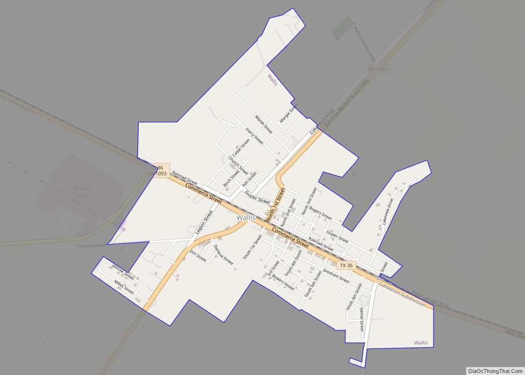
Map of Waller city, Texas

Map of Waller city, Texas

Waller is a city in Texas, United States, partly in Waller County and partly in Harris County within the Houston–Cypress metropolitan area. Its population was 2,682 at the 2020 U.S. census. The Waller area is located along U.S. Route 290 (Northwest Freeway) 41 miles (66 km) northwest of downtown Houston. Waller city overview: Name: Waller city … Read more

Map of Wake Village city

Map of Wake Village city

Wake Village is a city in Bowie County, Texas, United States, and a suburb of Texarkana, Texas. It is part of the Texarkana metropolitan area. The population was 5,945 at the 2020 census. Wake Village city overview: Name: Wake Village city LSAD Code: 25 LSAD Description: city (suffix) State: Texas County: Bowie County Elevation: 341 ft … Read more

Map of Waelder city

Map of Waelder city

Waelder (/ˈwɛldər/ WEL-dər) is a city in Gonzales County, Texas, United States and is also part of the Texas-German belt. The population was 933 at the 2020 census. Waelder city overview: Name: Waelder city LSAD Code: 25 LSAD Description: city (suffix) State: Texas County: Gonzales County Elevation: 381 ft (116 m) Total Area: 1.29 sq mi (3.33 km²) Land Area: … Read more

Map of Von Ormy city

Map of Von Ormy city

Von Ormy (/vɒn ˈɔːrmi/ von OR-mee) is a city in southwest Bexar County, Texas, United States. As of the 2020 census, it had a population of 1,174. It is part of the San Antonio metropolitan statistical area. It has been known as Von Ormy since the late 1880s. Prior to 1880, the community was known … Read more

Map of Volente village

Map of Volente village

Volente is a village in Travis County, Texas (USA) located on the north shore of Lake Travis. A post office was first established at Volente in 1886 with Andrew J. Stanford as postmaster but was not incorporated until 2003. The population was 520 at the 2010 census. Volente village overview: Name: Volente village LSAD Code: … Read more

Map of Vinton village, Texas

Map of Vinton village, Texas

Vinton is a village in El Paso County, Texas, United States. The population was 1,971 at the 2010 census. It is part of the El Paso Metropolitan Statistical Area. Vinton village overview: Name: Vinton village LSAD Code: 47 LSAD Description: village (suffix) State: Texas County: El Paso County Incorporated: 1961 Elevation: 3,796 ft (1,157 m) Total Area: … Read more

Map of Watauga city, Texas

Map of Watauga city, Texas

Watauga (/wɒˈtɔːɡə/) is a city in Tarrant County, Texas, United States, and a suburb of Fort Worth. The population was 23,497 at the 2010 census. The city’s businesses and retail markets are generally located on Highway 377. Watauga city overview: Name: Watauga city LSAD Code: 25 LSAD Description: city (suffix) State: Texas County: Tarrant County … Read more

Map of Waskom city

Map of Waskom city

Waskom is a city in the U.S. state of Texas with a 2020 census-tabulated population of 1,910, down from 2,160 residents in 2010. It is located in Harrison County and lies approximately 19 miles (31 km) east of the county seat, Marshall, on U.S. Route 80 and Interstate 20. Waskom forms part of Greater Marshall, which … Read more

Map of Welch CDP, Texas

Map of Welch CDP, Texas

Welch is a census-designated place and unincorporated community in Dawson County, Texas, United States. As of the 2010 census it had a population of 222. The Dawson Independent School District serves area students. Welch CDP overview: Name: Welch CDP LSAD Code: 57 LSAD Description: CDP (suffix) State: Texas County: Dawson County Elevation: 3,120 ft (950 m) Total … Read more

Map of Weir city, Texas

Map of Weir city, Texas

Weir is a city in Williamson County, Texas, United States. The population was 450 at the 2010 census. Weir city overview: Name: Weir city LSAD Code: 25 LSAD Description: city (suffix) State: Texas County: Williamson County Elevation: 682 ft (208 m) Total Area: 1.64 sq mi (4.25 km²) Land Area: 1.62 sq mi (4.19 km²) Water Area: 0.03 sq mi (0.07 km²) Total Population: 450 Population … Read more

Map of Weinert city

Map of Weinert city

Weinert is a city in Haskell County, Texas, United States. The population was 172 at the 2010 census. Weinert city overview: Name: Weinert city LSAD Code: 25 LSAD Description: city (suffix) State: Texas County: Haskell County Elevation: 1,526 ft (465 m) Total Area: 0.48 sq mi (1.25 km²) Land Area: 0.48 sq mi (1.25 km²) Water Area: 0.00 sq mi (0.00 km²) Total Population: 172 Population … Read more

Map of Weimar city

Map of Weimar city

Weimar (/ˈwaɪmər/ or, by many non-locals, /ˈwiːmər/) is a city in Colorado County, Texas, United States. The population was 2,076 at the 2020 census. It is part of the Texas-German belt region and was founded and named by German emigrants after the city of Weimar, Germany. In 1873 the town was founded in anticipation that … Read more