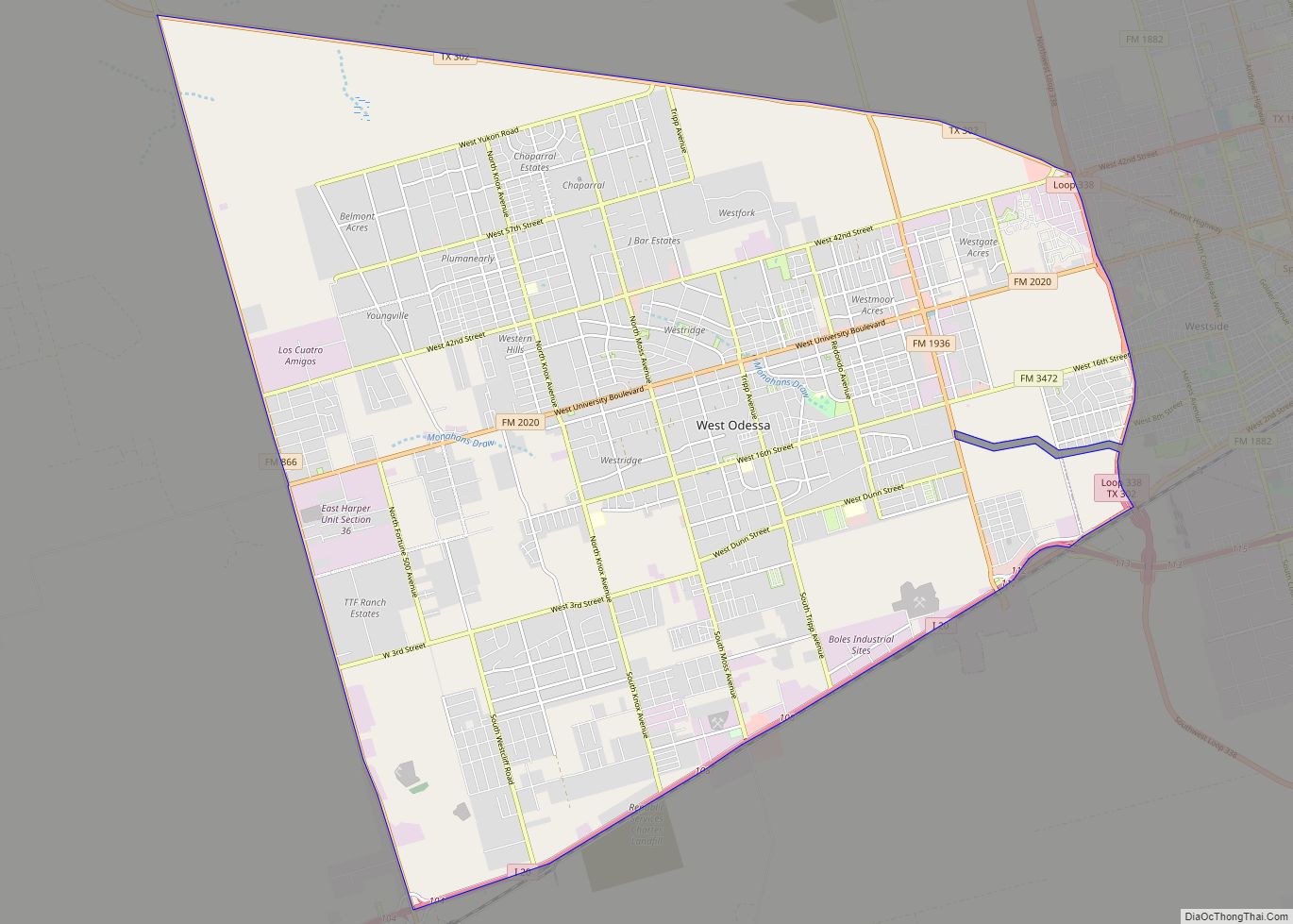
Map of Weslaco city

Map of Weslaco city

Weslaco /ˈwɛsləˌkoʊ/ is a city in Hidalgo County, Texas, United States. As of the 2020 census the population was 41,103, and in 2020 the estimated population was 41,103. It is located at the southern tip of Texas in the Rio Grande Valley near the Mexican border, across the Rio Grande from the city of Nuevo … Read more

Map of Wells town, Texas

Map of Wells town, Texas

Wells is a town in Cherokee County, Texas, United States. The population was 790 at the 2010 census, and 853 at the 2020 U.S. census. Wells town overview: Name: Wells town LSAD Code: 43 LSAD Description: town (suffix) State: Texas County: Cherokee County Elevation: 325 ft (99 m) Total Area: 1.92 sq mi (4.96 km²) Land Area: 1.92 sq mi (4.96 km²) Water … Read more

Map of Westlake town, Texas

Map of Westlake town, Texas

Westlake is a town in Denton and Tarrant counties in the U.S. state of Texas and a suburb of the Dallas-Fort Worth metroplex. The population is 1,900 as of the 2020 United States census. Westlake town overview: Name: Westlake town LSAD Code: 43 LSAD Description: town (suffix) State: Texas County: Denton County, Tarrant County Incorporated: … Read more

Map of Western Lake CDP

Map of Western Lake CDP

Western Lake is a census-designated place in Parker County, Texas, United States. This was a new CDP for the 2010 census with a population of 1,525. Western Lake CDP overview: Name: Western Lake CDP LSAD Code: 57 LSAD Description: CDP (suffix) State: Texas County: Parker County Elevation: 807 ft (246 m) Total Area: 3.52 sq mi (9.1 km²) Land Area: … Read more

Map of Westdale CDP

Map of Westdale CDP

Westdale is a census-designated place (CDP) in Jim Wells County, Texas, United States. The population was 372 at the 2010 census, up from 295 at the 2000 census. Westdale CDP overview: Name: Westdale CDP LSAD Code: 57 LSAD Description: CDP (suffix) State: Texas County: Jim Wells County Elevation: 213 ft (65 m) Total Area: 4.03 sq mi (10.43 km²) Land … Read more

Map of Westbrook city, Texas

Map of Westbrook city, Texas

Westbrook is a city in Mitchell County, Texas, United States. The population was 203 at the 2000 census. Westbrook city overview: Name: Westbrook city LSAD Code: 25 LSAD Description: city (suffix) State: Texas County: Mitchell County Elevation: 2,162 ft (659 m) Total Area: 0.42 sq mi (1.09 km²) Land Area: 0.42 sq mi (1.09 km²) Water Area: 0.00 sq mi (0.00 km²) Total Population: 253 Population … Read more

Map of West city, Texas

Map of West city, Texas

West is a city in McLennan County, Texas, United States. As of the 2020 census, the city population was 2,531. It is named after Thomas West, the first postmaster of the city. The city is located in the north-central part of Texas, approximately 70 miles (110 km) south of the Dallas-Fort Worth Metroplex, 20 miles north … Read more

Map of West University Place city

Map of West University Place city

West University Place, often called West University or West U for short, is a city located in the U.S. state of Texas within the Houston–Sugar Land metropolitan area and southwestern Harris County. At the 2020 U.S. census, the population of the city was 14,955. It is nicknamed “The Neighborhood City” and is mainly a bedroom … Read more

Map of West Tawakoni city

Map of West Tawakoni city

West Tawakoni (/təˈwɑːkəni/ tə-WAH-kə-nee) is a city in Hunt County, Texas, United States. The population was 1,895 at the 2020 census. West Tawakoni is located on the west side of Lake Tawakoni, while its twin city East Tawakoni is located on the east side of the lake in Rains County. West Tawakoni city overview: Name: … Read more

Map of West Sharyland CDP

Map of West Sharyland CDP

West Sharyland is a census-designated place (CDP) in Hidalgo County, Texas. The population was 2,309 at the 2010 United States Census. It is part of the McAllen–Edinburg–Mission Metropolitan Statistical Area. West Sharyland CDP overview: Name: West Sharyland CDP LSAD Code: 57 LSAD Description: CDP (suffix) State: Texas County: Hidalgo County Elevation: 171 ft (52 m) Total Area: … Read more

Map of West Orange city

Map of West Orange city

West Orange is a city in Orange County, Texas. The population was 3,459 at the 2020 census, up from 3,443 at the 2010 census. It is part of the Beaumont–Port Arthur Metropolitan Statistical Area. West Orange city overview: Name: West Orange city LSAD Code: 25 LSAD Description: city (suffix) State: Texas County: Orange County Elevation: … Read more

Map of Westminster CDP, Texas

Map of Westminster CDP, Texas

Westminster (/wɛstˈmɪnstər/) is an unincorporated community and census-designated place (CDP) in northeastern Collin County, Texas, United States. The population was 861 as of the 2010 census, up from 390 at the 2000 census, at which time it was a city. Westminster is located at the intersection of FM 3133 and FM 2862, northeast of McKinney, … Read more