Map of Coyote Flats city

Map of Coyote Flats city

Coyote Flats is a city in Johnson County in the U.S. state of Texas. As of the 2010 census, before the community was incorporated, the population was 312. Coyote Flats city overview: Name: Coyote Flats city LSAD Code: 25 LSAD Description: city (suffix) State: Texas County: Johnson County Elevation: 860 ft (260 m) Total Area: 3.36 sq mi (8.71 km²) … Read more

Map of Coyote Acres CDP

Map of Coyote Acres CDP

Coyote Acres is a census-designated place (CDP) in Jim Wells County, Texas, United States. The population was 508 at the 2010 census, up from 389 at the 2000 census. Coyote Acres CDP overview: Name: Coyote Acres CDP LSAD Code: 57 LSAD Description: CDP (suffix) State: Texas County: Jim Wells County Elevation: 230 ft (70 m) Total Area: … Read more

Map of Coyanosa CDP

Map of Coyanosa CDP

Coyanosa is an unincorporated desert village in Pecos County, Texas, located in the Permian Basin in West Texas, United States. Its population was 163 at the 2010 census. Part of the Coyanosa Draw runs adjacent to the town, 2.2 miles to the west. There is a food store, two Mexican restaurants, a public library, an … Read more

Map of Covington city, Texas

Map of Covington city, Texas

Covington is a city in Hill County in central Texas, United States. Located at the intersection of FM 67 and State Highway 171, 14 miles (23 km) north of Hillsboro, it is near the northern boundary of Hill County. It was founded by Colonel James Jackson Gathings, formerly of North Carolina and Mississippi, in the spring … Read more

Map of Cove city, Texas

Map of Cove city, Texas

Cove is a city in Chambers County, Texas, United States. The population was 525 at the 2020 census, up from 510 at the 2010 census. Cove city overview: Name: Cove city LSAD Code: 25 LSAD Description: city (suffix) State: Texas County: Chambers County Elevation: 23 ft (7 m) Total Area: 1.27 sq mi (3.28 km²) Land Area: 1.22 sq mi (3.15 km²) Water … Read more

Map of Coupland city

Map of Coupland city

Coupland (/ˈkoʊplənd/ KOHP-lənd) is a city in southeastern Williamson County, Texas, United States. According to the 2019 Population Estimate of the United States Census, the population was 317. Coupland’s athletic teams are the “Cowboys.” The Coupland Independent School District serves area students. Coupland ISD serves grades K–8. Upon graduation, the students go to Elgin, Texas, … Read more

Map of Country Acres CDP

Map of Country Acres CDP

Country Acres is a census-designated place (CDP) in San Patricio County, Texas, United States. The population was 185 at the 2010 census. Prior to the 2010 census Country Acres was part of the Falman-County Acres CDP. Country Acres CDP overview: Name: Country Acres CDP LSAD Code: 57 LSAD Description: CDP (suffix) State: Texas County: San … Read more

Map of Cotulla city

Map of Cotulla city

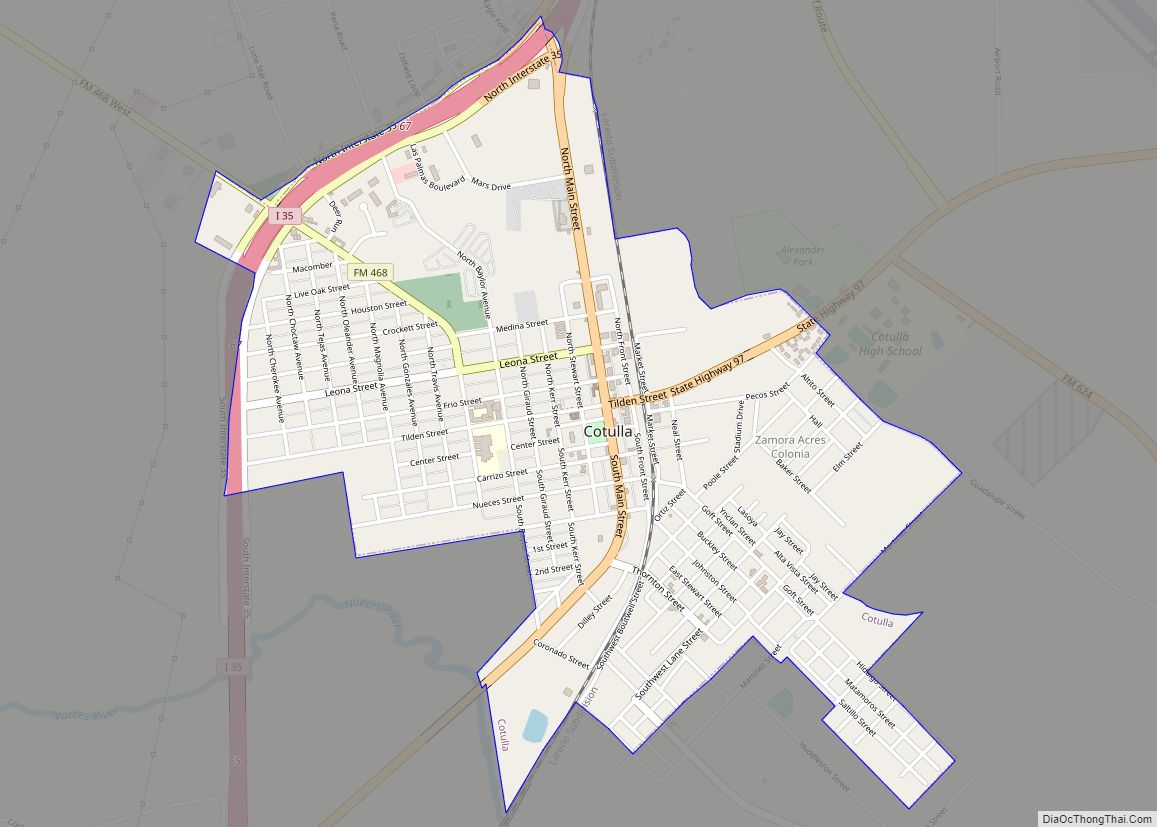
Cotulla (/kəˈtjuːlə/ kə-TEW-lə) is a city in and the county seat of La Salle County, Texas, United States. Its population was 3,718 as of the 2020 census. Cotulla city overview: Name: Cotulla city LSAD Code: 25 LSAD Description: city (suffix) State: Texas County: La Salle County Elevation: 440 ft (130 m) Total Area: 2.01 sq mi (5.21 km²) Land Area: … Read more

Map of Cottonwood city, Texas

Map of Cottonwood city, Texas

Cottonwood is a city in Kaufman County, Texas, United States. The population was 185 at the 2010 census. Cottonwood city overview: Name: Cottonwood city LSAD Code: 25 LSAD Description: city (suffix) State: Texas County: Kaufman County Elevation: 413 ft (126 m) Total Area: 1.56 sq mi (4.04 km²) Land Area: 1.56 sq mi (4.04 km²) Water Area: 0.00 sq mi (0.00 km²) Total Population: 185 Population … Read more

Map of Cottonwood Shores city

Map of Cottonwood Shores city

Cottonwood Shores is a city in Burnet County, Texas, United States. The population was 1,123 at the 2010 census. Cottonwood Shores city overview: Name: Cottonwood Shores city LSAD Code: 25 LSAD Description: city (suffix) State: Texas County: Burnet County Elevation: 830 ft (253 m) Total Area: 1.07 sq mi (2.77 km²) Land Area: 1.07 sq mi (2.77 km²) Water Area: 0.00 sq mi (0.00 km²) Total … Read more

Map of Crawford town, Texas

Map of Crawford town, Texas

Crawford is a town located in western McLennan County, Texas, United States. Crawford is part of the Waco Metropolitan Statistical Area. As of the 2020 census, the town had a total population of 887. The town was incorporated on August 12, 1897. It is best known as the home of former President of the United … Read more

Map of Cranfills Gap city

Map of Cranfills Gap city

Cranfills Gap is a city located in Bosque County in central Texas, United States. It was founded by Norwegian Emigrants and to this day most residents can trace their lineage to those Norwegian Founders. The population was 281 at the 2010 census. Cranfills Gap city overview: Name: Cranfills Gap city LSAD Code: 25 LSAD Description: … Read more