Map of Crystal City, Texas
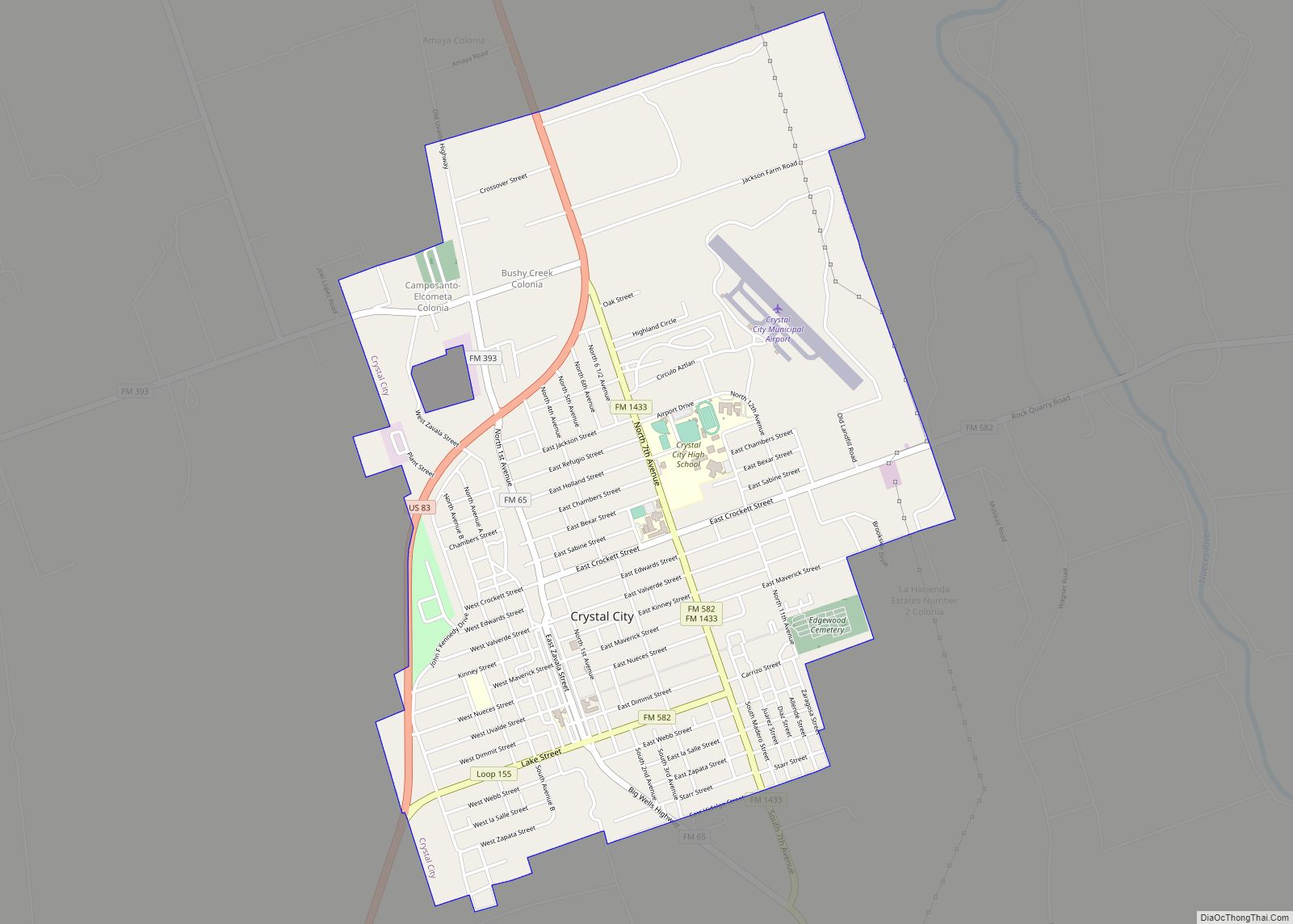
Crystal City is a city in and the county seat of Zavala County, Texas, United States. The population was 6,354 at the 2020 census. It was settled as a farming and ranching community and was a major railroad stop being 110 miles (180 km) from San Antonio. Spinach became a major crop and the city has ... Read more
Map of Crystal City, Texas
Map of Crowley city, Texas
Crowley is a city located mainly in Tarrant County in the U.S. state of Texas. The population was 18,070 at the 2020 census, up 40.8% from the 2010 census. Crowley city overview: Name: Crowley city LSAD Code: 25 LSAD Description: city (suffix) State: Texas County: Johnson County, Tarrant County Elevation: 778 ft (237 m) Total Area: 7.32 sq mi ... Read more
Map of Crowley city, Texas
Map of Crowell city
Crowell (/ˈkroʊəl/ KROH-əl) is a city in Foard County, Texas, United States. It serves as the county seat, and the population was 948 at the 2010 census, down from 1,141 at the 2000 census. Crowell city overview: Name: Crowell city LSAD Code: 25 LSAD Description: city (suffix) State: Texas County: Foard County Elevation: 1,473 ft (449 m) ... Read more
Map of Crowell city
Map of Cross Timber town
Cross Timber is a town in Johnson County, Texas, in the United States. As of the 2010 census the population was 268. Cross Timber town overview: Name: Cross Timber town LSAD Code: 43 LSAD Description: town (suffix) State: Texas County: Johnson County Elevation: 709 ft (216 m) Total Area: 1.41 sq mi (3.65 km²) Land Area: 1.41 sq mi (3.65 km²) Water Area: ... Read more
Map of Cross Timber town
Map of Cross Roads town, Texas
Cross Roads is a town in Denton County, Texas, United States. The population was 1,744 in 2020. Cross Roads town overview: Name: Cross Roads town LSAD Code: 43 LSAD Description: town (suffix) State: Texas County: Denton County Elevation: 633 ft (193 m) Total Area: 6.80 sq mi (17.61 km²) Land Area: 6.72 sq mi (17.41 km²) Water Area: 0.08 sq mi (0.20 km²) Total Population: 1,744 ... Read more
Map of Cross Roads town, Texas
Map of Cross Plains town, Texas
Cross Plains is a town in Callahan County, Texas, United States. The population was 982 at the 2010 census. It is part of the Abilene, Texas Metropolitan Statistical Area. Cross Plains town overview: Name: Cross Plains town LSAD Code: 43 LSAD Description: town (suffix) State: Texas County: Callahan County Elevation: 1,736 ft (529 m) Total Area: 1.20 sq mi ... Read more
Map of Cross Plains town, Texas
Map of César Chávez CDP
César Chávez is a census-designated place (CDP) in Hidalgo County, Texas. The population was 1,929 at the 2010 United States Census. It is part of the McAllen–Edinburg–Mission Metropolitan Statistical Area. César Chávez CDP overview: Name: César Chávez CDP LSAD Code: 57 LSAD Description: CDP (suffix) State: Texas County: Hidalgo County Elevation: 85 ft (26 m) Total Area: ... Read more
Map of César Chávez CDP
Map of Cut and Shoot city
Cut and Shoot is a city in eastern Montgomery County, Texas, United States, about 6 mi (9.7 km) east of Conroe and 40 mi (64 km) north of Houston. Until 2006, Cut and Shoot was considered and called a town. Then, the town council elected for it to be considered and referred to as a city. The population was ... Read more
Map of Cut and Shoot city
Map of Cushing city, Texas
Cushing is a city in Nacogdoches County, Texas, United States. The population was 612 at the 2010 census. Cushing city overview: Name: Cushing city LSAD Code: 25 LSAD Description: city (suffix) State: Texas County: Nacogdoches County Elevation: 410 ft (120 m) Total Area: 1.38 sq mi (3.56 km²) Land Area: 1.37 sq mi (3.55 km²) Water Area: 0.00 sq mi (0.00 km²) Total Population: 612 Population ... Read more
Map of Cushing city, Texas
Map of Cuney town
Cuney is a town located in northwest Cherokee County, Texas, United States. With a population of 116 at the 2020 U.S. census, Cuney was the only “wet” town in Cherokee County from the mid-1980s until 2009, when voters in Rusk came out in favor of beer/wine sales. After that result, voters in Jacksonville and Frankston ... Read more
Map of Cuney town
Map of Damon CDP
Damon is a census-designated place (CDP) in Brazoria County, Texas, United States. The population was 552 at the 2010 census. The town is located about 20 miles (32 km) south of Rosenberg on Texas State Highway 36. Damon sits partly atop a salt dome which was exploited for petroleum, sulphur, and limestone. Damon CDP overview: Name: ... Read more
Map of Damon CDP
Map of Dalworthington Gardens city
Dalworthington Gardens is a city in Tarrant County, Texas, United States and a suburb of Arlington. Its population was 2,259 at the 2010 census. Dalworthington Gardens city overview: Name: Dalworthington Gardens city LSAD Code: 25 LSAD Description: city (suffix) State: Texas County: Tarrant County Elevation: 571 ft (174 m) Total Area: 1.82 sq mi (4.72 km²) Land Area: 1.79 sq mi (4.63 km²) ... Read more
Map of Dalworthington Gardens city