Crowell (/ˈkroʊəl/ KROH-əl) is a city in Foard County, Texas, United States. It serves as the county seat, and the population was 948 at the 2010 census, down from 1,141 at the 2000 census.
| Name: | Crowell city |
|---|---|
| LSAD Code: | 25 |
| LSAD Description: | city (suffix) |
| State: | Texas |
| County: | Foard County |
| Elevation: | 1,473 ft (449 m) |
| Total Area: | 1.89 sq mi (4.89 km²) |
| Land Area: | 1.89 sq mi (4.88 km²) |
| Water Area: | 0.00 sq mi (0.00 km²) |
| Total Population: | 749 |
| Population Density: | 433.19/sq mi (167.29/km²) |
| ZIP code: | 79227 |
| Area code: | 940 |
| FIPS code: | 4817948 |
| GNISfeature ID: | 1355438 |
| Website: | www.crowelltex.com |
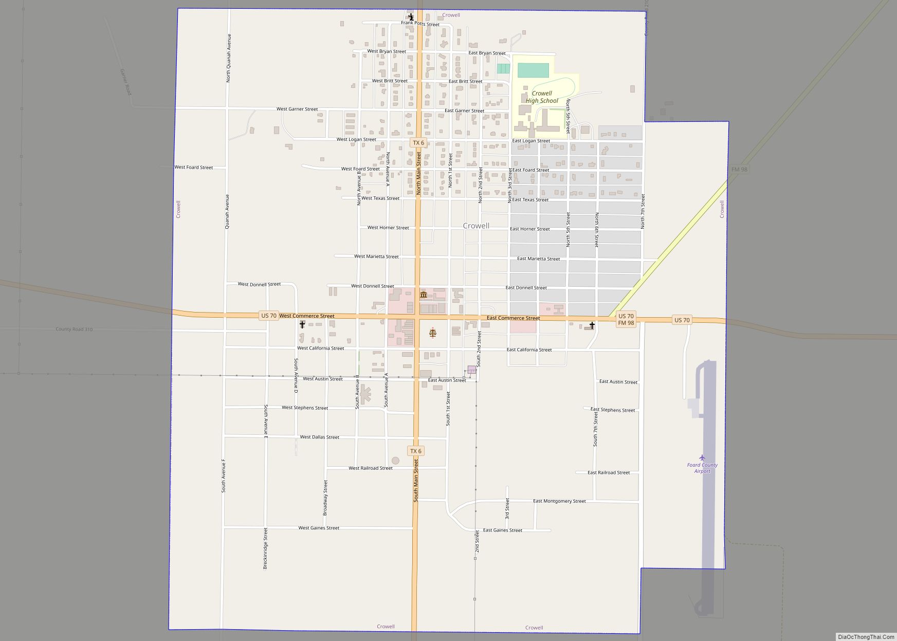
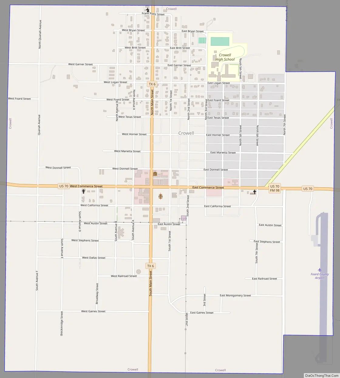
Online Interactive Map
Click on ![]() to view map in "full screen" mode.
to view map in "full screen" mode.
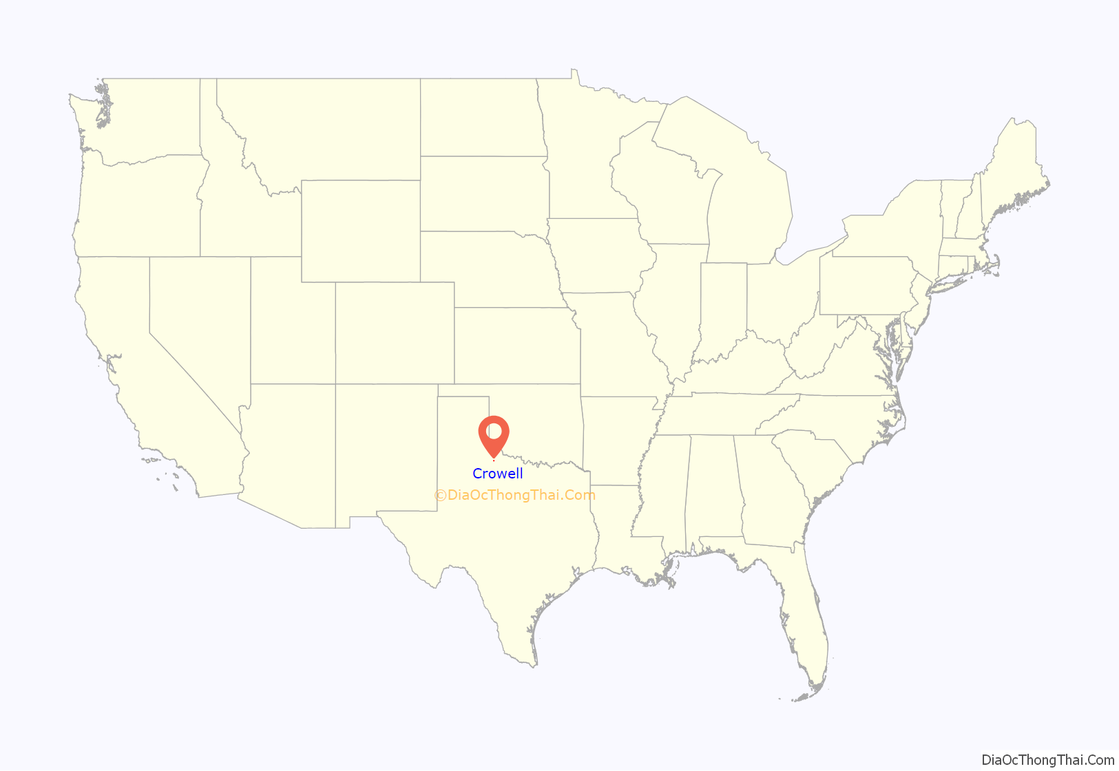
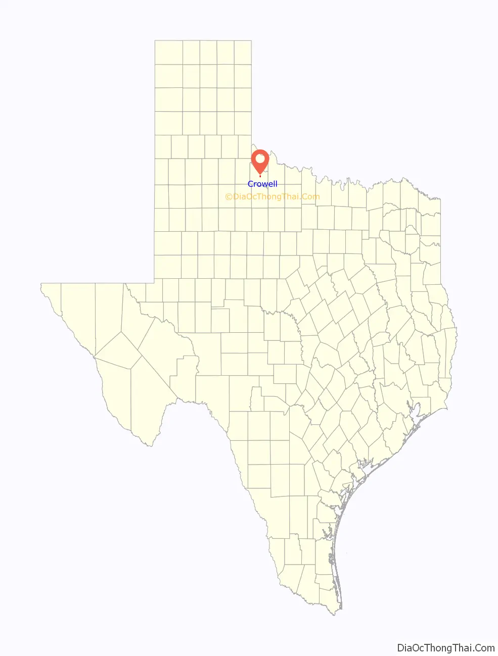
Crowell location map. Where is Crowell city?
History
Located between the Pease River to the north and the North Wichita River to the south, the area has long been home to a variety of hardy animal and plant species. Native grasses tend to be hardy and drought-tolerant. Tree varieties include bush juniper, mesquite, hackberry, mulberry, and pecan, in addition to several imports that thrive in the warm, semiarid conditions. Native animals species include coyotes, squirrels, badgers, raccoons, and foxes. Deer have also become plentiful in recent decades, as have feral pigs. Bird species include quail, dove, and several types of migratory waterfowl. Crowell is on the migration path of the monarch butterfly.
Crowell is only a few miles from the recapture location of Cynthia Ann Parker. Known locally as the Pease River battleground, Cynthia Ann, captured as a child by raiding Indians, was recaptured here as an adult by U.S. soldiers. Cynthia Ann was the mother of Quanah Parker, considered the last great chief of the Comanche.
Though few notables and celebrities call Crowell home, some worth mentioning remain. Former football star Dick Todd set long-standing records as a running back for Texas A&M University. He then went on to play for, and eventually coach, the Washington Redskins. Todd’s son, Denny, died as a teenager from injuries sustained on the football field. His memory is honored each year with an award in his name. The award is presented to the football team member who shows the greatest personal contribution to the team, both on and off the field.
The remote, rural location minimizes light pollution, making for an excellent view of the night sky. As a result, Crowell is home to Comanche Springs Astronomy Campus, a 50-acre (200,000 m) observatory built by the Three Rivers Foundation for the Arts and Sciences. The economy is almost solely agrarian. Beef cattle, wheat, and cotton are the primary sources of income and employment. Hunting leases are quickly becoming a notable contributor to the local economy. The single manufacturing industry is a cap factory. Formerly owned by the DeLong company, the factory is now owned by a group of local investors.
Though a small, rural community, Crowell still has interests. In addition to the observatory, a museum was built by the Foard County Historical Society. Housed in the former firehouse, the museum boasts artifacts from the history of Crowell and environs. Most notable is the one-of-a-kind scale town. The diorama-style exhibits are designed to reflect the historically notable businesses in city history. Just across the street from the Firehall Museum is the Farm Implement Museum.
Crowell Road Map
Crowell city Satellite Map

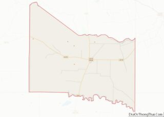
Geography
Crowell is located near the center of Foard County at 33°59′9″N 99°43′28″W / 33.98583°N 99.72444°W / 33.98583; -99.72444 (33.985838, –99.724430). U.S. Route 70 passes through the city as Commerce Street, leading east 33 miles (53 km) to Vernon and west 36 miles (58 km) to Paducah. Texas State Highway 6 (Main Street) crosses US 70 in the center of Crowell, leading north 22 miles (35 km) to Quanah and south 28 miles (45 km) to Benjamin. Wichita Falls is 81 miles (130 km) to the east via US 70 and US 287.
According to the United States Census Bureau, Crowell has a total area of 1.9 sq mi (4.9 km), all of it land.
The elevation at the center of town is 1,476 ft (450 m) above sea level. The terrain is varied, but mostly level with rolling hills. Soil varies from slightly sandy loam to mostly sandy. Soil and meteorological conditions make the area suitable for growing wheat, cotton, and hay crops (alfalfa and cane). Little of the area immediately around Crowell has underground water in amounts suitable for irrigation. The majority of the area immediately east of Crowell is dedicated to cultivated crops. The majority of the area immediately west of Crowell is dedicated to raising beef cattle.
See also
Map of Texas State and its subdivision:- Anderson
- Andrews
- Angelina
- Aransas
- Archer
- Armstrong
- Atascosa
- Austin
- Bailey
- Bandera
- Bastrop
- Baylor
- Bee
- Bell
- Bexar
- Blanco
- Borden
- Bosque
- Bowie
- Brazoria
- Brazos
- Brewster
- Briscoe
- Brooks
- Brown
- Burleson
- Burnet
- Caldwell
- Calhoun
- Callahan
- Cameron
- Camp
- Carson
- Cass
- Castro
- Chambers
- Cherokee
- Childress
- Clay
- Cochran
- Coke
- Coleman
- Collin
- Collingsworth
- Colorado
- Comal
- Comanche
- Concho
- Cooke
- Coryell
- Cottle
- Crane
- Crockett
- Crosby
- Culberson
- Dallam
- Dallas
- Dawson
- Deaf Smith
- Delta
- Denton
- Dewitt
- Dickens
- Dimmit
- Donley
- Duval
- Eastland
- Ector
- Edwards
- El Paso
- Ellis
- Erath
- Falls
- Fannin
- Fayette
- Fisher
- Floyd
- Foard
- Fort Bend
- Franklin
- Freestone
- Frio
- Gaines
- Galveston
- Garza
- Gillespie
- Glasscock
- Goliad
- Gonzales
- Gray
- Grayson
- Gregg
- Grimes
- Guadalupe
- Hale
- Hall
- Hamilton
- Hansford
- Hardeman
- Hardin
- Harris
- Harrison
- Hartley
- Haskell
- Hays
- Hemphill
- Henderson
- Hidalgo
- Hill
- Hockley
- Hood
- Hopkins
- Houston
- Howard
- Hudspeth
- Hunt
- Hutchinson
- Irion
- Jack
- Jackson
- Jasper
- Jeff Davis
- Jefferson
- Jim Hogg
- Jim Wells
- Johnson
- Jones
- Karnes
- Kaufman
- Kendall
- Kenedy
- Kent
- Kerr
- Kimble
- King
- Kinney
- Kleberg
- Knox
- La Salle
- Lamar
- Lamb
- Lampasas
- Lavaca
- Lee
- Leon
- Liberty
- Limestone
- Lipscomb
- Live Oak
- Llano
- Loving
- Lubbock
- Lynn
- Madison
- Marion
- Martin
- Mason
- Matagorda
- Maverick
- McCulloch
- McLennan
- McMullen
- Medina
- Menard
- Midland
- Milam
- Mills
- Mitchell
- Montague
- Montgomery
- Moore
- Morris
- Motley
- Nacogdoches
- Navarro
- Newton
- Nolan
- Nueces
- Ochiltree
- Oldham
- Orange
- Palo Pinto
- Panola
- Parker
- Parmer
- Pecos
- Polk
- Potter
- Presidio
- Rains
- Randall
- Reagan
- Real
- Red River
- Reeves
- Refugio
- Roberts
- Robertson
- Rockwall
- Runnels
- Rusk
- Sabine
- San Augustine
- San Jacinto
- San Patricio
- San Saba
- Schleicher
- Scurry
- Shackelford
- Shelby
- Sherman
- Smith
- Somervell
- Starr
- Stephens
- Sterling
- Stonewall
- Sutton
- Swisher
- Tarrant
- Taylor
- Terrell
- Terry
- Throckmorton
- Titus
- Tom Green
- Travis
- Trinity
- Tyler
- Upshur
- Upton
- Uvalde
- Val Verde
- Van Zandt
- Victoria
- Walker
- Waller
- Ward
- Washington
- Webb
- Wharton
- Wheeler
- Wichita
- Wilbarger
- Willacy
- Williamson
- Wilson
- Winkler
- Wise
- Wood
- Yoakum
- Young
- Zapata
- Zavala
- Alabama
- Alaska
- Arizona
- Arkansas
- California
- Colorado
- Connecticut
- Delaware
- District of Columbia
- Florida
- Georgia
- Hawaii
- Idaho
- Illinois
- Indiana
- Iowa
- Kansas
- Kentucky
- Louisiana
- Maine
- Maryland
- Massachusetts
- Michigan
- Minnesota
- Mississippi
- Missouri
- Montana
- Nebraska
- Nevada
- New Hampshire
- New Jersey
- New Mexico
- New York
- North Carolina
- North Dakota
- Ohio
- Oklahoma
- Oregon
- Pennsylvania
- Rhode Island
- South Carolina
- South Dakota
- Tennessee
- Texas
- Utah
- Vermont
- Virginia
- Washington
- West Virginia
- Wisconsin
- Wyoming