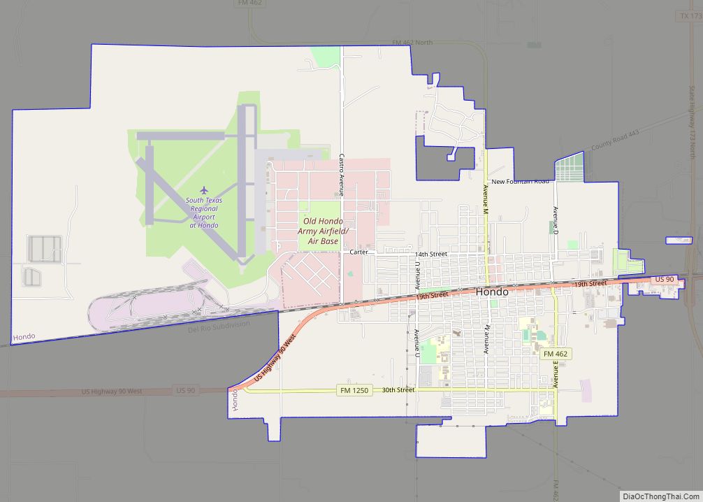
Map of Howardwick city

Map of Howardwick city

Howardwick is a city in Donley County, Texas, United States. Its population was 402 at the 2010 census. Howardwick city overview: Name: Howardwick city LSAD Code: 25 LSAD Description: city (suffix) State: Texas County: Donley County Elevation: 2,769 ft (844 m) Total Area: 2.03 sq mi (5.26 km²) Land Area: 2.03 sq mi (5.26 km²) Water Area: 0.00 sq mi (0.00 km²) Total Population: 402 Population … Read more

Map of Horseshoe Bend CDP, Texas

Map of Horseshoe Bend CDP, Texas

Horseshoe Bend is a census-designated place in Parker County, Texas, United States. This was a new CDP for the 2010 census with a population of 789. Horseshoe Bend CDP overview: Name: Horseshoe Bend CDP LSAD Code: 57 LSAD Description: CDP (suffix) State: Texas County: Parker County Elevation: 718 ft (219 m) Total Area: 1.73 sq mi (4.5 km²) Land Area: … Read more

Map of Huntsville city, Texas

Map of Huntsville city, Texas

Huntsville is a city in and the county seat of Walker County, Texas. The population was 45,941 as of the 2020 census. It is the center of the Huntsville micropolitan area. Huntsville is in the East Texas Piney Woods on Interstate 45 and home to Texas State Prison, Sam Houston State University, the Texas Department … Read more

Map of Huntington city, Texas

Map of Huntington city, Texas

Huntington is a city in Angelina County, Texas, United States. The population was 2,025 at the 2020 census. The site is named for Collis Potter Huntington, the chairman of the board of the Southern Pacific Railroad when the town was formed and one of the Big Four. Huntington is known as the “Gateway to Lake … Read more

Map of Hunters Creek Village city

Map of Hunters Creek Village city

Hunters Creek Village is a city in Harris County, Texas, United States, part of the Greater Houston metropolitan area. The population was 4,385 at the 2020 census. It is part of a collection of upscale residential communities in west Houston known as the Memorial Villages. As of 2000, Hunters Creek Village was the 5th wealthiest … Read more

Map of Hungerford CDP

Map of Hungerford CDP

Hungerford is a census-designated place (CDP) in northeastern Wharton County, Texas, United States. U.S. Route 59, Texas State Highway 60, and Farm to Market Road 1161 intersect in the community. The Kansas City Southern Railway Co. passes through Hungerford. The population was 347 at the 2010 census. It is located on what in the 1820s … Read more

Map of Humble city

Map of Humble city

Humble (/ˈʌmbəl/ UM-bəl) is a city located in the Houston metropolitan area. Humble became an oil boomtown in the early 20th century when oil was first discovered there in 1904. By 1905, the Humble oilfield was the largest producing oilfield in Texas. Humble was home of The Humble Oil and Refining Company, a predecessor of … Read more

Map of Hull CDP, Texas

Map of Hull CDP, Texas

Hull is an unincorporated community and census-designated place (CDP) in Liberty County, Texas, United States. It was named after W. F. Hull, a railroad official. The population was 669 at the 2010 census. Hull CDP overview: Name: Hull CDP LSAD Code: 57 LSAD Description: CDP (suffix) State: Texas County: Liberty County Elevation: 66 ft (20 m) Total … Read more

Map of Hughes Springs city

Map of Hughes Springs city

Hughes Springs is a city in Cass and Morris counties in the U.S. state of Texas. At the 2020 census, its population was 1,575. The town has heavily damaged by an EF2 tornado on November 4, 2022. Hughes Springs city overview: Name: Hughes Springs city LSAD Code: 25 LSAD Description: city (suffix) State: Texas County: … Read more

Map of Hudson city, Texas

Map of Hudson city, Texas

Hudson is a city in Angelina County, Texas, United States. The population was 4,849 at the 2020 census. Hudson city overview: Name: Hudson city LSAD Code: 25 LSAD Description: city (suffix) State: Texas County: Angelina County Elevation: 335 ft (102 m) Total Area: 5.11 sq mi (13.23 km²) Land Area: 5.07 sq mi (13.13 km²) Water Area: 0.04 sq mi (0.10 km²) Total Population: 4,849 Population … Read more

Map of Hudson Oaks city

Map of Hudson Oaks city

Hudson Oaks is a city in Parker County, Texas, United States located in the Dallas-Fort Worth Metroplex. The population was 2,174 in 2020. Hudson Oaks city overview: Name: Hudson Oaks city LSAD Code: 25 LSAD Description: city (suffix) State: Texas County: Parker County Elevation: 1,043 ft (318 m) Total Area: 3.10 sq mi (8.02 km²) Land Area: 3.10 sq mi (8.02 km²) Water … Read more

Map of Hudson Bend CDP

Map of Hudson Bend CDP

Hudson Bend is a census-designated place (CDP) in Travis County, Texas, United States. The population was 2,981 at the 2010 census. Hudson Bend CDP overview: Name: Hudson Bend CDP LSAD Code: 57 LSAD Description: CDP (suffix) State: Texas County: Travis County Elevation: 755 ft (230 m) Total Area: 6.7 sq mi (17.3 km²) Land Area: 4.0 sq mi (10.3 km²) Water Area: 2.7 sq mi … Read more