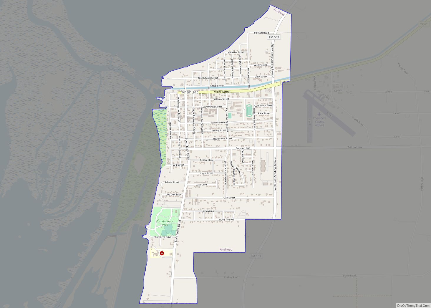
Map of Amherst city, Texas
Amherst is a city in Lamb County, Texas, United States. The population was 721 at the 2010 census. Amherst city overview: Name: Amherst city LSAD Code: 25 LSAD Description: city (suffix) State: Texas County: Lamb County Elevation: 3,652 ft (1,113 m) Total Area: 0.92 sq mi (2.37 km²) Land Area: 0.92 sq mi (2.37 km²) Water Area: 0.00 sq mi (0.00 km²) Total Population: 721 Population ... Read more
Map of Amherst city, Texas
Map of Ames city, Texas
Ames is a city in Liberty County, Texas, United States. The population was 937 at the 2020 census. Ames city overview: Name: Ames city LSAD Code: 25 LSAD Description: city (suffix) State: Texas County: Liberty County Elevation: 72 ft (22 m) Total Area: 3.30 sq mi (8.55 km²) Land Area: 3.30 sq mi (8.55 km²) Water Area: 0.00 sq mi (0.00 km²) Total Population: 937 Population ... Read more
Map of Ames city, Texas
Map of Anna city, Texas
Anna is a city in the U.S. state of Texas. Located in Collin County, its population was 16,896 at the 2020 U.S. census. Anna city overview: Name: Anna city LSAD Code: 25 LSAD Description: city (suffix) State: Texas County: Collin County Elevation: 712 ft (217 m) Total Area: 16.53 sq mi (42.82 km²) Land Area: 16.45 sq mi (42.59 km²) Water Area: 0.09 sq mi ... Read more
Map of Anna city, Texas
Map of Angus city
Angus is a city in Navarro County, Texas, United States. The population was 414 at the 2010 census. Angus city overview: Name: Angus city LSAD Code: 25 LSAD Description: city (suffix) State: Texas County: Navarro County Elevation: 436 ft (133 m) Total Area: 3.30 sq mi (8.54 km²) Land Area: 3.29 sq mi (8.52 km²) Water Area: 0.01 sq mi (0.02 km²) Total Population: 414 Population ... Read more
Map of Angus city
Map of Angleton city
Angleton is a city in and the county seat of Brazoria County, Texas, United States, within the Houston–The Woodlands–Sugar Land metropolitan area. Angleton lies at the intersection of State Highway 288, State Highway 35, and the Union Pacific Railroad. The population was 19,429 at the 2020 census. Angleton is in the 14th congressional district, and ... Read more
Map of Angleton city
Map of Andrews city, Texas
Andrews is the county seat of Andrews County in the Permian Basin of West Texas. Andrews sits to the far southwest within the Texas Panhandle’s plains, about 30 miles east of New Mexico. Andrews was incorporated on February 2, 1937. Both the city and county were named for Richard Andrews, the first Texan soldier to ... Read more
Map of Andrews city, Texas
Map of Aransas Pass city
Aransas Pass (/əˈrænzəs/ ə-RAN-zəs) is a city in Aransas, Nueces, and San Patricio Counties in the U.S. state of Texas. The population was 7,941 at the 2020 Census. Aransas Pass city overview: Name: Aransas Pass city LSAD Code: 25 LSAD Description: city (suffix) State: Texas County: Aransas County, Nueces County, San Patricio County Elevation: 16 ft ... Read more
Map of Aransas Pass city
Map of Aquilla city, Texas
Aquilla (/əˈkwɪlə/ ə-KWIL-ə) is a city located in Hill County, Texas, United States. It is located on Farm Road 933 16 miles (26 km) southwest of Hillsboro. The population was 109 at the 2010 census. Aquilla city overview: Name: Aquilla city LSAD Code: 25 LSAD Description: city (suffix) State: Texas County: Hill County Elevation: 522 ft (159 m) ... Read more
Map of Aquilla city, Texas
Map of Appleby city
Appleby is a city in Nacogdoches County, in the U.S. state of Texas. The population was 474 at the 2010 census. Appleby city overview: Name: Appleby city LSAD Code: 25 LSAD Description: city (suffix) State: Texas County: Nacogdoches County Elevation: 410 ft (120 m) Total Area: 2.15 sq mi (5.58 km²) Land Area: 2.15 sq mi (5.58 km²) Water Area: 0.00 sq mi (0.00 km²) Total ... Read more
Map of Appleby city
Map of Anton city
Anton (/ˈæntən/ ANT-ən) is a city in Hockley County, Texas, United States. The population was 1,126 at the 2010 census. Anton city overview: Name: Anton city LSAD Code: 25 LSAD Description: city (suffix) State: Texas County: Hockley County Elevation: 3,389 ft (1,033 m) Total Area: 0.78 sq mi (2.02 km²) Land Area: 0.78 sq mi (2.02 km²) Water Area: 0.00 sq mi (0.00 km²) Total Population: ... Read more
Map of Anton city
Map of Anthony town, Texas
Anthony is an incorporated town in El Paso County, Texas, United States. The population was 5,011 at the 2010 census. As of July 1, 2018, the population estimate for the town from the U.S. Census was 5,655. It is the first town encountered in Texas when traveling southbound on Interstate 10 from New Mexico. Anthony ... Read more
Map of Anthony town, Texas
Map of Anson city, Texas
Anson is a city in and the county seat of Jones County, Texas, United States. The population was 2,430 at the 2010 census. It is part of the Abilene, Texas metropolitan area. Originally named “Jones City”, the town was renamed “Anson” in 1882 in honor of Anson Jones, the last president of the Republic of ... Read more
Map of Anson city, Texas