Map of Longoria CDP

Map of Longoria CDP

Longoria is a census-designated place (CDP) in Starr County, Texas, United States. This was a new CDP for the 2010 census with a population of 92. Longoria CDP overview: Name: Longoria CDP LSAD Code: 57 LSAD Description: CDP (suffix) State: Texas County: Starr County Total Area: 92 FIPS code: 4843822 Online Interactive Map Longoria online … Read more

Map of Lone Star city

Map of Lone Star city

Lone Star is a city in Morris County, Texas, United States. Its population was 1,581 at the 2010 census. Lone Star city overview: Name: Lone Star city LSAD Code: 25 LSAD Description: city (suffix) State: Texas County: Morris County Elevation: 348 ft (106 m) Total Area: 2.00 sq mi (5.18 km²) Land Area: 1.98 sq mi (5.12 km²) Water Area: 0.02 sq mi (0.05 km²) Total … Read more

Map of Lone Oak city, Texas

Map of Lone Oak city, Texas

Lone Oak is a city in Hunt County, Texas, United States. The population was 598 at the 2010 census, up from 521 at the 2000 census. Lone Oak city overview: Name: Lone Oak city LSAD Code: 25 LSAD Description: city (suffix) State: Texas County: Hunt County Elevation: 564 ft (172 m) Total Area: 1.11 sq mi (2.88 km²) Land Area: … Read more

Map of Lometa city

Map of Lometa city

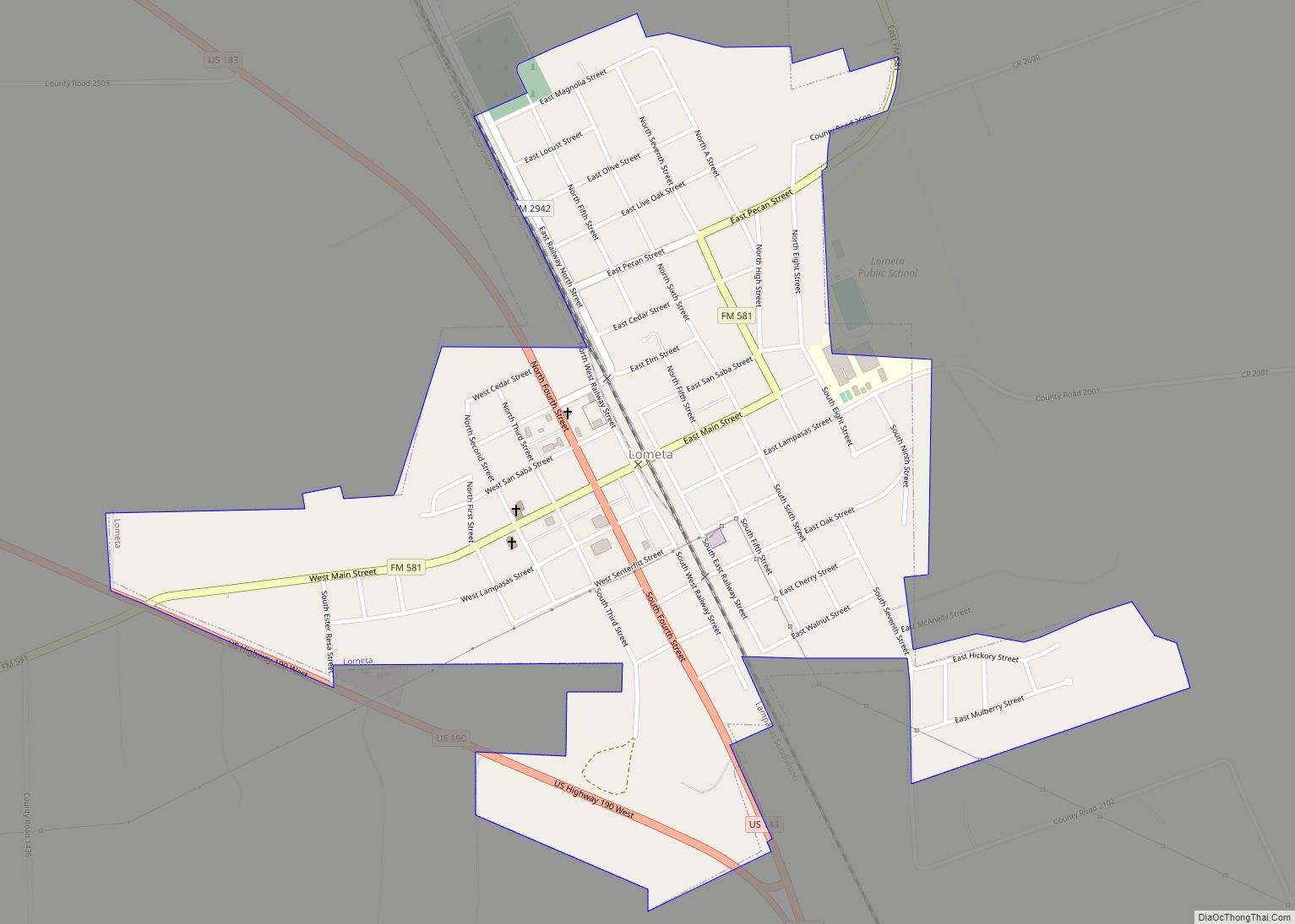
Lometa (/loʊˈmiːtə/ loh-MEE-tə) is a city in Lampasas County, Texas, United States. The population was 856 at the 2010 census. It is part of the Killeen–Temple–Fort Hood metropolitan statistical area. Lometa city overview: Name: Lometa city LSAD Code: 25 LSAD Description: city (suffix) State: Texas County: Lampasas County Elevation: 1,493 ft (455 m) Total Area: 0.84 sq mi (2.17 km²) … Read more

Map of Loma Vista CDP

Map of Loma Vista CDP

Loma Vista is a census-designated place (CDP) in Starr County, Texas, United States. It is a new CDP formed from part of the North Escobares CDP prior to the 2010 census with a population of 160. Loma Vista CDP overview: Name: Loma Vista CDP LSAD Code: 57 LSAD Description: CDP (suffix) State: Texas County: Starr … Read more

Map of Loma Linda CDP, Texas

Map of Loma Linda CDP, Texas

Loma Linda is a census-designated place (CDP) in San Patricio County, Texas, United States. The population was 122 at the 2010 census. Prior to the 2010 census Loma Linda was part of the Del Sol-Loma Linda CDP. Loma Linda CDP overview: Name: Loma Linda CDP LSAD Code: 57 LSAD Description: CDP (suffix) State: Texas County: … Read more

Map of Los Angeles CDP, Texas

Map of Los Angeles CDP, Texas

Los Angeles is a census-designated place (CDP) in Willacy County, Texas, United States. The population was 121 at the 2010 census. Prior to the 2010 census, the CDP was known as Los Angeles Subdivision. Los Angeles CDP overview: Name: Los Angeles CDP LSAD Code: 57 LSAD Description: CDP (suffix) State: Texas County: Willacy County Elevation: … Read more

Map of Los Alvarez CDP

Map of Los Alvarez CDP

Los Alvarez is a census-designated place (CDP) in Starr County, Texas, United States. The population was 303 at the 2010 census down from 1,434 at the 2000 census. Los Alvarez CDP overview: Name: Los Alvarez CDP LSAD Code: 57 LSAD Description: CDP (suffix) State: Texas County: Starr County Elevation: 197 ft (60 m) Total Area: 0.1 sq mi (0.3 km²) … Read more

Map of Los Altos CDP, Texas

Map of Los Altos CDP, Texas

Los Altos is a census-designated place (CDP) in Webb County, Texas, United States. This was a new CDP formed from parts of the Laredo Ranchettes CDP prior to the 2010 census with a population of 140. It is one of several colonias in Webb County. Los Altos CDP overview: Name: Los Altos CDP LSAD Code: … Read more

Map of Lorenzo city, Texas

Map of Lorenzo city, Texas

Lorenzo is a city in Crosby County, Texas, United States. As of the 2010 census, the city population was 1,147, down from 1,372 in 2000. It is part of the Lubbock Metropolitan Statistical Area. Lorenzo city overview: Name: Lorenzo city LSAD Code: 25 LSAD Description: city (suffix) State: Texas County: Crosby County Elevation: 3,166 ft (965 m) … Read more

Map of Lorena city

Map of Lorena city

Lorena is a small city in McLennan County, Texas, United States. The population was 1,785 at the 2020 census. It is part of the Waco Metropolitan Statistical Area. Lorena city overview: Name: Lorena city LSAD Code: 25 LSAD Description: city (suffix) State: Texas County: McLennan County Elevation: 604 ft (184 m) Total Area: 3.40 sq mi (8.80 km²) Land Area: … Read more

Map of Loraine town, Texas

Map of Loraine town, Texas

Loraine is a town in Mitchell County, Texas, United States. The population was 602 at the 2010 census. Loraine town overview: Name: Loraine town LSAD Code: 43 LSAD Description: town (suffix) State: Texas County: Mitchell County Elevation: 2,267 ft (691 m) Total Area: 1.04 sq mi (2.69 km²) Land Area: 1.04 sq mi (2.69 km²) Water Area: 0.00 sq mi (0.00 km²) Total Population: 602 Population … Read more