Map of Taylorsville city, Utah
Taylorsville is a city in Salt Lake County, Utah. It is part of the Salt Lake City metropolitan area. The population was 60,448 at the time of the 2020 census. Taylorsville was incorporated from the Taylorsville–Bennion CDP and portions of the Kearns metro township on July 1, 1996. The city is located adjacent to Interstate ... Read more
Map of Taylorsville city, Utah
Map of Tabiona town
Tabiona (/tæbiˈoʊnə/ TAB-ee-OH-nə) is a town in Duchesne County, Utah, United States. It is eighty-six miles southeast of the Salt Lake City metropolitan area. The population was 171 at the 2010 United States Census. Tabiona town overview: Name: Tabiona town LSAD Code: 43 LSAD Description: town (suffix) State: Utah County: Duchesne County Incorporated: 1935 Elevation: ... Read more
Map of Tabiona town
Map of Syracuse city, Utah
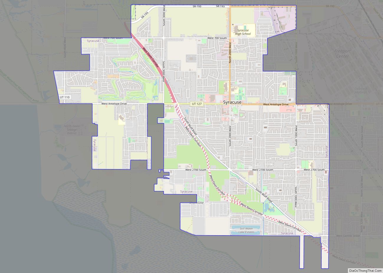
Syracuse is a city in Davis County, Utah, United States. It is situated between the Great Salt Lake and Interstate 15, about 30 miles (48 km) north of Salt Lake City. It is part of the Ogden–Clearfield, Utah Metropolitan Statistical Area. The city has seen rapid growth and development since the 1990s. The city population was ... Read more
Map of Syracuse city, Utah
Map of Sutherland CDP, Utah
Sutherland is a census-designated place in northeastern Millard County, Utah, United States. The population was 165 at the 2010 census. Sutherland CDP overview: Name: Sutherland CDP LSAD Code: 57 LSAD Description: CDP (suffix) State: Utah County: Millard County Founded: 1909 Elevation: 4,626 ft (1,410 m) Total Area: 2.2 sq mi (6 km²) Land Area: 2.2 sq mi (6 km²) Water Area: 0.0 sq mi (0 km²) ... Read more
Map of Sutherland CDP, Utah
Map of Sunset city, Utah
Sunset is a city in Davis County, Utah, United States. It is part of the Ogden–Clearfield, Utah Metropolitan Statistical Area. The population was 5,122 at the 2010 census. Sunset emerged as a distinct place in 1916. Sunset city overview: Name: Sunset city LSAD Code: 25 LSAD Description: city (suffix) State: Utah County: Davis County Incorporated: ... Read more
Map of Sunset city, Utah
Map of Summit CDP, Utah
Summit is an unincorporated community and census-designated place (CDP) in east-central Iron County, Utah, United States. The population was 160 at the 2010 census. Summit CDP overview: Name: Summit CDP LSAD Code: 57 LSAD Description: CDP (suffix) State: Utah County: Iron County Elevation: 5,955 ft (1,815 m) Total Area: 0.7 sq mi (1.8 km²) Land Area: 0.7 sq mi (1.8 km²) Water Area: ... Read more
Map of Summit CDP, Utah
Map of Summit Park CDP
Summit Park is a census-designated place (CDP) on the western edge of Summit County, Utah, United States. The population was 6,597 at the 2000 census. Summit Park CDP overview: Name: Summit Park CDP LSAD Code: 57 LSAD Description: CDP (suffix) State: Utah County: Summit County Elevation: 6,886 ft (2,099 m) Total Area: 21.7 sq mi (56.2 km²) Land Area: 21.7 sq mi ... Read more
Map of Summit Park CDP
Map of Stockton town, Utah
Stockton is a town in Tooele County, Utah, United States. It is part of the Salt Lake City, Utah Metropolitan Statistical Area. The population was 616 at the 2010 census. Stockton town overview: Name: Stockton town LSAD Code: 43 LSAD Description: town (suffix) State: Utah County: Tooele County Incorporated: 1901 Elevation: 5,118 ft (1,560 m) Total Area: ... Read more
Map of Stockton town, Utah
Map of Sterling town, Utah
Sterling is a town in Sanpete County, Utah, United States. The population was 235 at the 2000 census. Sterling town overview: Name: Sterling town LSAD Code: 43 LSAD Description: town (suffix) State: Utah County: Sanpete County Incorporated: 1934 Elevation: 5,574 ft (1,699 m) Total Area: 0.32 sq mi (0.84 km²) Land Area: 0.32 sq mi (0.84 km²) Water Area: 0.00 sq mi (0.00 km²) Total Population: ... Read more
Map of Sterling town, Utah
Map of Timber Lakes CDP
Timber Lakes is a census-designated place (CDP) in Wasatch County, Utah, United States. The population was 607 at the 2010 census, up from 289 in 2000. Timber Lakes CDP overview: Name: Timber Lakes CDP LSAD Code: 57 LSAD Description: CDP (suffix) State: Utah County: Wasatch County Elevation: 7,717 ft (2,352 m) Total Area: 2.8 sq mi (7.2 km²) Land Area: ... Read more
Map of Timber Lakes CDP
Map of Thompson Springs CDP
Thompson Springs, also officially known for a time as just Thompson, is a small census-designated place in central Grand County, Utah, United States. The population was 39 at the 2010 census. The town is just north of the east–west highway route shared by Interstate 70, U.S. Route 6 and U.S. Route 50, between Crescent Junction ... Read more
Map of Thompson Springs CDP
Map of Thatcher CDP, Utah
Thatcher is a census-designated place in Box Elder County, Utah, United States. It is a small farming community, located 3 miles (5 km) southwest of Bothwell and 7 miles (11 km) west of Tremonton. The population was 789 at the 2010 census. The community was named for Moses Thatcher, an apostle for the Church of Jesus Christ ... Read more
Map of Thatcher CDP, Utah