Map of Richmond CDP, Vermont
Richmond is the primary village and a census-designated place (CDP) in the town of Richmond, Chittenden County, Vermont, United States. As of the 2020 census, it had a population of 853, out of 4,167 in the entire town of Richmond. The village is in eastern Chittenden County, in the north-central part of the town of ... Read more
Map of Richmond CDP, Vermont
Map of Richford CDP
Richford is a census-designated place comprising the main settlement in the town of Richford, Franklin County, Vermont, United States. Its population was 1,361 as of the 2010 census, out of 2,308 people in the entire town of Richford. The Richford CDP is located in the northwest part of the town of Richford, along the Missisquoi ... Read more
Map of Richford CDP
Map of Readsboro CDP
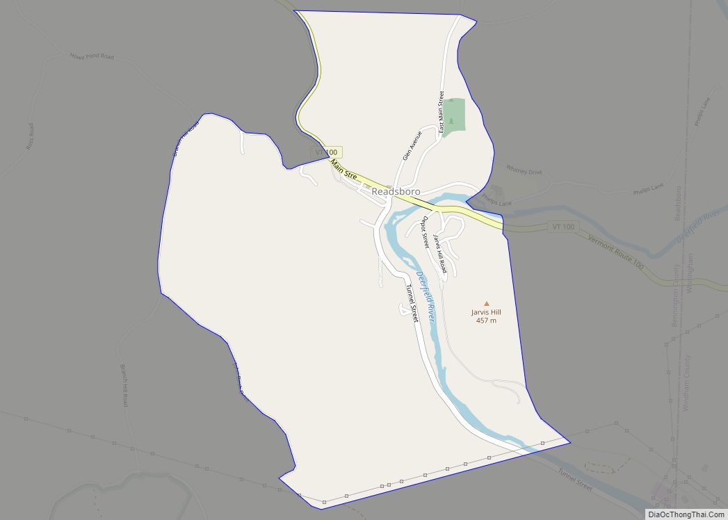
Readsboro is the primary village and a census-designated place (CDP) in the town of Readsboro, Bennington County, Vermont, United States. As of the 2020 census, it had a population of 297, out of 702 in the entire town of Readsboro. It is in southeastern Bennington County, in the southeast part of the town of Readsboro, ... Read more
Map of Readsboro CDP
Map of Randolph CDP, Vermont
Randolph is the primary village and a census-designated place (CDP) in the town of Randolph, Orange County, Vermont, United States. As of the 2020 census, it had a population of 2,083, out of 4,774 in the entire town of Randolph. The CDP is in southwestern Orange County, in the southwest corner of the town of ... Read more
Map of Randolph CDP, Vermont
Map of South Burlington city
South Burlington city overview: Name: South Burlington city LSAD Code: 25 LSAD Description: city (suffix) State: Vermont County: Chittenden County FIPS code: 5066175 Online Interactive Map South Burlington online map. Source: Basemap layers from Google Map, Open Street Map (OSM), Arcgisonline, Wmflabs. Boundary Data from Database of Global Administrative Areas. South Burlington location map. Where ... Read more
Map of South Burlington city
Map of South Barre CDP
South Barre is a census-designated place (CDP) in the town of Barre in Washington County, Vermont, United States. The population was 1,242 at the 2000 census. South Barre CDP overview: Name: South Barre CDP LSAD Code: 57 LSAD Description: CDP (suffix) State: Vermont County: Washington County Elevation: 738 ft (225 m) Total Area: 2.1 sq mi (5.4 km²) Land Area: ... Read more
Map of South Barre CDP
Map of Waitsfield CDP
Waitsfield is a census-designated place (CDP) in the town of Waitsfield, Washington County, Vermont, United States. The population of the CDP was 164 at the 2010 census. Waitsfield CDP overview: Name: Waitsfield CDP LSAD Code: 57 LSAD Description: CDP (suffix) State: Vermont County: Washington County Elevation: 700 ft (200 m) Total Area: 0.40 sq mi (1.03 km²) Land Area: 0.39 sq mi ... Read more
Map of Waitsfield CDP
Map of Vergennes city, Vermont
Vergennes city overview: Name: Vergennes city LSAD Code: 25 LSAD Description: city (suffix) State: Vermont County: Addison County FIPS code: 5074650 Online Interactive Map Vergennes online map. Source: Basemap layers from Google Map, Open Street Map (OSM), Arcgisonline, Wmflabs. Boundary Data from Database of Global Administrative Areas. Vergennes location map. Where is Vergennes city? Vergennes ... Read more
Map of Vergennes city, Vermont
Map of Troy CDP, Vermont
Troy is an unincorporated village and census-designated place (CDP) in the town of Troy, Orleans County, Vermont, United States. As of the 2020 census, it had a population of 261, out of 1,722 in the entire town of Troy. The CDP is in northwestern Orleans County, in the west-central part of the town. Its western ... Read more
Map of Troy CDP, Vermont
Map of Swanton village, Vermont
Swanton is a town in Franklin County, Vermont, United States. The population was 6,701 at the 2020 census. The town includes the village of Swanton. Swanton village overview: Name: Swanton village LSAD Code: 47 LSAD Description: village (suffix) State: Vermont County: Franklin County Elevation: 150 ft (50 m) Total Area: 61.7 sq mi (159.7 km²) Land Area: 48.0 sq mi (124.4 km²) Water ... Read more
Map of Swanton village, Vermont
Map of St. Albans city, Vermont
Saint Albans, commonly abbreviated as St. Albans, is a town in Franklin County, Vermont, United States. As of the 2020 census, the population was 6,988. The town completely surrounds St. Albans City, which is a separate municipality. St. Albans city overview: Name: St. Albans city LSAD Code: 25 LSAD Description: city (suffix) State: Vermont County: ... Read more
Map of St. Albans city, Vermont
Map of Springfield CDP, Vermont
Springfield is a census-designated place (CDP) comprising the main settlement within the town of Springfield, Windsor County, Vermont, United States. The population of the CDP was 3,979 at the 2010 census, compared with 9,373 for the town as a whole. Springfield CDP overview: Name: Springfield CDP LSAD Code: 57 LSAD Description: CDP (suffix) State: Vermont ... Read more
Map of Springfield CDP, Vermont