Map of Worcester CDP, Vermont
Worcester is a census-designated place (CDP) that comprises the main village in the town of Worcester, Washington County, Vermont, United States. The population of the CDP was 112 at the 2010 census. Worcester CDP overview: Name: Worcester CDP LSAD Code: 57 LSAD Description: CDP (suffix) State: Vermont County: Washington County Elevation: 775 ft (236 m) Total Area: ... Read more
Map of Worcester CDP, Vermont
Map of Woodstock village, Vermont
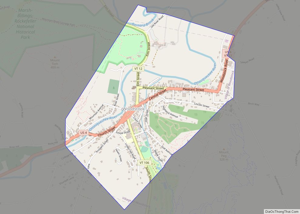
Woodstock is the shire town (county seat) of Windsor County, Vermont, United States. As of the 2020 census, the town population was 3,005. It includes the villages of Woodstock, South Woodstock, Taftsville, and West Woodstock. Woodstock village overview: Name: Woodstock village LSAD Code: 47 LSAD Description: village (suffix) State: Vermont County: Windsor County Elevation: 702 ft ... Read more
Map of Woodstock village, Vermont
Map of Winooski city
Winooski city overview: Name: Winooski city LSAD Code: 25 LSAD Description: city (suffix) State: Vermont County: Chittenden County FIPS code: 5085150 Online Interactive Map Winooski online map. Source: Basemap layers from Google Map, Open Street Map (OSM), Arcgisonline, Wmflabs. Boundary Data from Database of Global Administrative Areas. Winooski location map. Where is Winooski city? Winooski ... Read more
Map of Winooski city
Map of Windsor CDP, Vermont
Windsor is a census-designated place (CDP) comprising the main settlement within the town of Windsor, Windsor County, Vermont, United States. The population of the CDP was 2,066 at the 2010 census, compared with 3,553 for the town as a whole. Windsor CDP overview: Name: Windsor CDP LSAD Code: 57 LSAD Description: CDP (suffix) State: Vermont ... Read more
Map of Windsor CDP, Vermont
Map of Wilmington CDP, Vermont
Wilmington is the primary village and a census-designated place (CDP) in the town of Wilmington, Windham County, Vermont, United States. As of the 2020 census, it had a population of 439, compared to 2,255 in the entire town. The center of the village is part of the Wilmington Village Historic District. The CDP is in ... Read more
Map of Wilmington CDP, Vermont
Map of Williamstown CDP, Vermont
Williamstown is the primary village and a census-designated place (CDP) in the town of Williamstown, Orange County, Vermont, United States. As of the 2020 census, it had a population of 1,264, out of 3,515 in the entire town of Williamstown. The CDP is in northwestern Orange County, in the north-central part of the town of ... Read more
Map of Williamstown CDP, Vermont
Map of Wilder CDP, Vermont
Wilder is an unincorporated village and census-designated place (CDP) within the town of Hartford in Windsor County, Vermont, United States. It is the location of the Wilder Dam on the Connecticut River. The population of the CDP was 1,690 at the 2010 census. The village center is an early example of a planned mill community, ... Read more
Map of Wilder CDP, Vermont
Map of Bristol CDP, Vermont
Bristol is the main settlement in the town of Bristol in Addison County, Vermont, United States, and a census-designated place (CDP). The population was 1,936 at the 2020 census, out of a total population of 3,782 in the town of Bristol. Bristol CDP overview: Name: Bristol CDP LSAD Code: 57 LSAD Description: CDP (suffix) State: ... Read more
Map of Bristol CDP, Vermont
Map of Cavendish CDP
Cavendish is a census-designated place, the central village of the town of Cavendish, Windsor County, Vermont, United States. Until the mid–nineteenth century it was known as Duttonsville. As of the 2010 census, the population of the CDP was 179, compared to 1,367 for the entire town of Cavendish. Cavendish is the site of the 1848 ... Read more
Map of Cavendish CDP
Map of Cambridge village, Vermont
Cambridge is a town in Lamoille County, Vermont, United States. The population was 3,839 at the 2020 United States Census. Cambridge includes the villages of Jeffersonville and Cambridge. Cambridge village overview: Name: Cambridge village LSAD Code: 47 LSAD Description: village (suffix) State: Vermont County: Lamoille County Elevation: 758 ft (231 m) Total Area: 63.69 sq mi (164.95 km²) Land Area: ... Read more
Map of Cambridge village, Vermont
Map of Cabot CDP, Vermont
Cabot is a New England town located in the northeast corner of Washington County, Vermont, United States. The population was 1,443 at the 2020 census. It contains the unincorporated villages of Cabot Village, Cabot Plains, South Cabot, East Cabot, Molly’s Pond (named after Molly, the wife of Indian Joe), and Lower Cabot. Cabot contains several ... Read more
Map of Cabot CDP, Vermont
Map of East Barre CDP
East Barre is a census-designated place (CDP) in the town of Barre, Washington County, Vermont, United States. The population of the CDP was 826 at the 2010 census. Prior to 2010, East Barre was part of the Graniteville-East Barre CDP, which consisted of three unincorporated villages in the town: Graniteville, East Barre, and Websterville. East ... Read more
Map of East Barre CDP