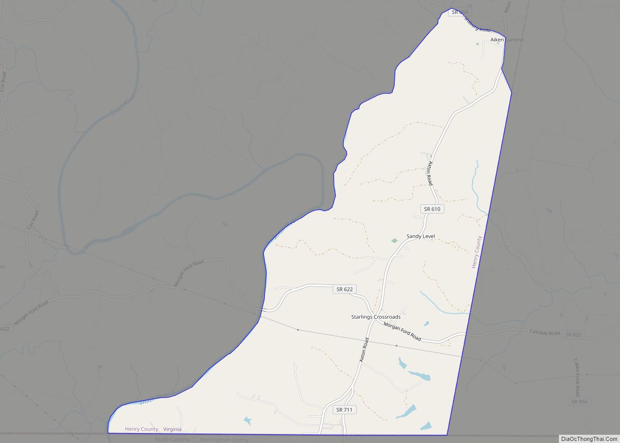
Map of Schuyler CDP, Virginia
Schuyler CDP overview: Name: Schuyler CDP LSAD Code: 57 LSAD Description: CDP (suffix) State: Virginia County: Nelson County FIPS code: 5170704 Online Interactive Map Schuyler online map. Source: Basemap layers from Google Map, Open Street Map (OSM), Arcgisonline, Wmflabs. Boundary Data from Database of Global Administrative Areas. Schuyler location map. Where is Schuyler CDP? Schuyler ... Read more
Map of Schuyler CDP, Virginia
Map of Saxis town
Saxis is a town in Accomack County, Virginia, United States. The population was 241 at the 2010 census. Saxis town overview: Name: Saxis town LSAD Code: 43 LSAD Description: town (suffix) State: Virginia County: Accomack County Elevation: 7 ft (2 m) Total Area: 0.41 sq mi (1.06 km²) Land Area: 0.41 sq mi (1.05 km²) Water Area: 0.01 sq mi (0.01 km²) Total Population: 241 Population ... Read more
Map of Saxis town
Map of Shenandoah Retreat CDP
Shenandoah Retreat is an unincorporated community and census-designated place in eastern Clarke County, Virginia, on the east shore of the Shenandoah River. The population as of the 2010 United States Census was 518. Shenandoah Retreat CDP overview: Name: Shenandoah Retreat CDP LSAD Code: 57 LSAD Description: CDP (suffix) State: Virginia County: Clarke County Elevation: 550 ft ... Read more
Map of Shenandoah Retreat CDP
Map of Shenandoah Farms CDP
Shenandoah Farms is an unincorporated community and census-designated place in northeastern Warren County, Virginia, United States. A small portion extends into neighboring Clarke County. The population as of the 2010 United States Census was 3,033. It is a recreational community built on the western slope of Blue Ridge Mountain and the banks of the Shenandoah ... Read more
Map of Shenandoah Farms CDP
Map of Shawsville CDP
Shawsville CDP overview: Name: Shawsville CDP LSAD Code: 57 LSAD Description: CDP (suffix) State: Virginia County: Montgomery County FIPS code: 5171632 Online Interactive Map Shawsville online map. Source: Basemap layers from Google Map, Open Street Map (OSM), Arcgisonline, Wmflabs. Boundary Data from Database of Global Administrative Areas. Shawsville location map. Where is Shawsville CDP? Shawsville ... Read more
Map of Shawsville CDP
Map of Shawneeland CDP
Shawneeland CDP overview: Name: Shawneeland CDP LSAD Code: 57 LSAD Description: CDP (suffix) State: Virginia County: Frederick County FIPS code: 5171625 Online Interactive Map Shawneeland online map. Source: Basemap layers from Google Map, Open Street Map (OSM), Arcgisonline, Wmflabs. Boundary Data from Database of Global Administrative Areas. Shawneeland location map. Where is Shawneeland CDP? Shawneeland ... Read more
Map of Shawneeland CDP
Map of Seven Mile Ford CDP
Seven Mile Ford CDP overview: Name: Seven Mile Ford CDP LSAD Code: 57 LSAD Description: CDP (suffix) State: Virginia County: Smyth County FIPS code: 5171264 Online Interactive Map Seven Mile Ford online map. Source: Basemap layers from Google Map, Open Street Map (OSM), Arcgisonline, Wmflabs. Boundary Data from Database of Global Administrative Areas. Seven Mile ... Read more
Map of Seven Mile Ford CDP
Map of Seven Corners CDP
Seven Corners is a commercial center and census-designated place (CDP) in Fairfax County, Virginia, United States. The population was 9,255 at the 2010 census. Seven Corners has a “Falls Church” mailing address but is not within Falls Church‘s city limits. The area got its name from the intersection of State Route 7 (Leesburg Pike and ... Read more
Map of Seven Corners CDP
Map of Selma CDP, Virginia
Selma is a census-designated place (CDP) in Alleghany County, Virginia, United States. The population was 529 at the 2010 census. Selma CDP overview: Name: Selma CDP LSAD Code: 57 LSAD Description: CDP (suffix) State: Virginia County: Alleghany County Elevation: 1,148 ft (350 m) Total Area: 0.3 sq mi (0.8 km²) Land Area: 0.3 sq mi (0.8 km²) Water Area: 0.0 sq mi (0.0 km²) Total Population: ... Read more
Map of Selma CDP, Virginia
Map of Sedley CDP
Sedley is a census-designated place (CDP) in the middle of Southampton County, Virginia, United States. The population as of the 2010 Census was 470. It lies at an elevation of 89 feet (27 m). Sedley CDP overview: Name: Sedley CDP LSAD Code: 57 LSAD Description: CDP (suffix) State: Virginia County: Southampton County FIPS code: 5171040 ... Read more
Map of Sedley CDP
Map of Scottsville town, Virginia
Scottsville is a town in Albemarle and Fluvanna counties in the U.S. state of Virginia. The population was 566 at the 2010 census. It is part of the Charlottesville Metropolitan Statistical Area. Scottsville town overview: Name: Scottsville town LSAD Code: 43 LSAD Description: town (suffix) State: Virginia County: Albemarle County, Fluvanna County Elevation: 279 ft (85 m) ... Read more
Map of Scottsville town, Virginia
Map of Sherando CDP
Sherando CDP overview: Name: Sherando CDP LSAD Code: 57 LSAD Description: CDP (suffix) State: Virginia County: Augusta County FIPS code: 5171904 Online Interactive Map Sherando online map. Source: Basemap layers from Google Map, Open Street Map (OSM), Arcgisonline, Wmflabs. Boundary Data from Database of Global Administrative Areas. Sherando location map. Where is Sherando CDP? Sherando ... Read more
Map of Sherando CDP