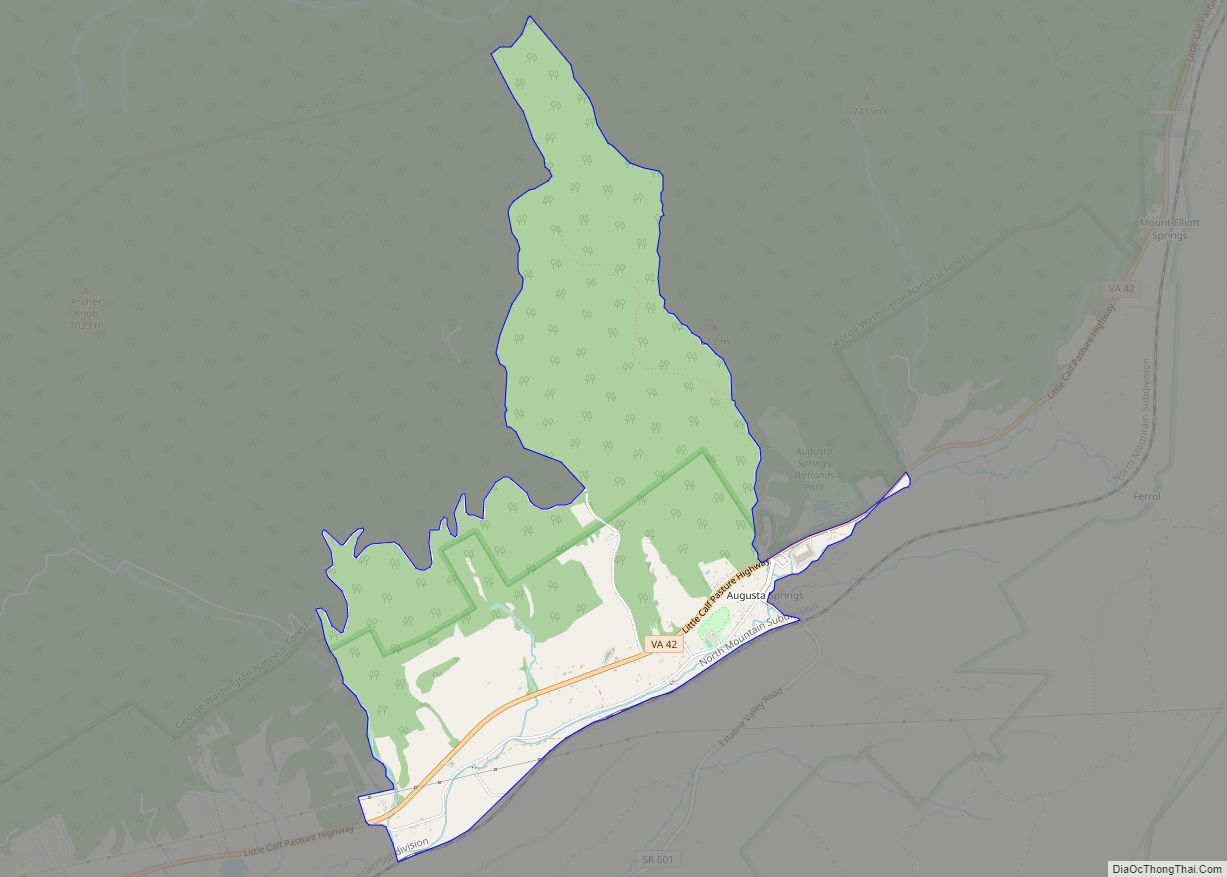
Map of Sherando CDP

Map of Sherando CDP

Sherando CDP overview: Name: Sherando CDP LSAD Code: 57 LSAD Description: CDP (suffix) State: Virginia County: Augusta County FIPS code: 5171904 Online Interactive Map Sherando online map. Source: Basemap layers from Google Map, Open Street Map (OSM), Arcgisonline, Wmflabs. Boundary Data from Database of Global Administrative Areas. Sherando location map. Where is Sherando CDP? Sherando … Read more

Map of Shenandoah town, Virginia

Map of Shenandoah town, Virginia

Shenandoah /ˌʃɛnənˈdoʊə/ is a town in Page County, Virginia, United States. The population was 2,373 at the 2010 census. Shenandoah town overview: Name: Shenandoah town LSAD Code: 43 LSAD Description: town (suffix) State: Virginia County: Page County Elevation: 988 ft (301 m) Total Area: 2.26 sq mi (5.86 km²) Land Area: 2.17 sq mi (5.61 km²) Water Area: 0.10 sq mi (0.25 km²) Total Population: 2,373 … Read more

Map of Shenandoah Shores CDP

Map of Shenandoah Shores CDP

Shenandoah Shores is a census-designated place in Warren County, Virginia, just north of Front Royal. The population as of the 2010 Census was 934. Shenandoah Shores CDP overview: Name: Shenandoah Shores CDP LSAD Code: 57 LSAD Description: CDP (suffix) State: Virginia County: Warren County Total Area: 934 ZIP code: 22630 FIPS code: 5171826 GNISfeature ID: … Read more

Map of South Hill town, Virginia

Map of South Hill town, Virginia

South Hill is a town in Mecklenburg County, Virginia, United States. The population was 4,650 at the 2010 census. Located on major Interstate and U.S. highways, it has a full-service hospital (serving patients from several rural counties), a tobacco market, and several hotels. South Hill has a close relationship with the neighboring town of La … Read more

Map of South Boston town

Map of South Boston town

South Boston, formerly Boyd’s Ferry, is a town in Halifax County, Virginia, United States. The population was 8,142 at the 2010 census, down from 8,491 at the 2000 census. It is the most populous town in Halifax County. South Boston town overview: Name: South Boston town LSAD Code: 43 LSAD Description: town (suffix) State: Virginia … Read more

Map of Snowville CDP, Virginia

Map of Snowville CDP, Virginia

Snowville is a census-designated place (CDP) located in southeastern Pulaski County in the Commonwealth of Virginia. The population, as of the 2010 Census, was 149. It is part of the Blacksburg–Christiansburg Metropolitan Statistical Area. Snowville CDP overview: Name: Snowville CDP LSAD Code: 57 LSAD Description: CDP (suffix) State: Virginia County: Pulaski County Elevation: 1,940 ft (591 m) … Read more

Map of St. Charles town, Virginia

Map of St. Charles town, Virginia

St. Charles is a town in Lee County, Virginia, United States. The population was 128 at the 2010 census, down from 159 at the 2000 census. St. Charles town overview: Name: St. Charles town LSAD Code: 43 LSAD Description: town (suffix) State: Virginia County: Lee County Elevation: 1,522 ft (464 m) Total Area: 0.18 sq mi (0.46 km²) Land Area: … Read more

Map of Springville CDP, Virginia

Map of Springville CDP, Virginia

Springville is a census-designated place in Tazewell County, Virginia. It is the midpoint between Bluefield and Tazewell on US 460 and US 19. The population as of the 2010 census was 1,371. Springville is home to several churches including Destiny Outreach Ministries and Springville Christian Church which is peoported to be the oldest congregation in … Read more

Map of Springfield CDP, Virginia

Map of Springfield CDP, Virginia

Springfield is a census-designated place (CDP) in Fairfax County, Virginia, United States. The Springfield CDP is recognized by the U.S. Census Bureau with a population of 30,484 as of the 2010 census. Homes and businesses in bordering CDPs including North Springfield, West Springfield, and Newington are usually given a Springfield mailing address. The population of … Read more

Map of Spotsylvania Courthouse CDP

Map of Spotsylvania Courthouse CDP

Spotsylvania Courthouse is a census-designated place (CDP) and the county seat of Spotsylvania County, Virginia, United States, located 10 miles (16 km) southwest of Fredericksburg. Recognized by the U.S. Census Bureau as a census designated place (CDP), the population was 4,239 at the 2010 census. During the American Civil War, the crossroads community became a Union … Read more

Map of Sperryville CDP

Map of Sperryville CDP

Sperryville is a census-designated place (CDP) located in the western section of Rappahannock County, Virginia, United States, near Shenandoah National Park. It consists of a village with two main streets along the two branches of the Thornton River, together with surrounding pasture- and farmland. The population as of the 2010 Census was 342. Sperryville CDP … Read more

Map of Southside Chesconessex CDP

Map of Southside Chesconessex CDP

Southside Chesconessex CDP overview: Name: Southside Chesconessex CDP LSAD Code: 57 LSAD Description: CDP (suffix) State: Virginia County: Accomack County FIPS code: 5174160 Online Interactive Map Southside Chesconessex online map. Source: Basemap layers from Google Map, Open Street Map (OSM), Arcgisonline, Wmflabs. Boundary Data from Database of Global Administrative Areas. Southside Chesconessex location map. Where … Read more