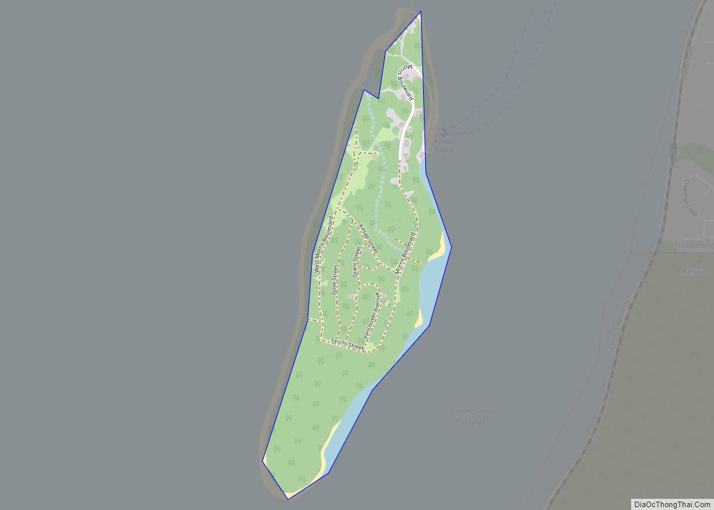
Map of Colton town, Washington

Map of Colton town, Washington

Colton town overview: Name: Colton town LSAD Code: 43 LSAD Description: town (suffix) State: Washington County: Whitman County FIPS code: 5313890 Online Interactive Map Colton online map. Source: Basemap layers from Google Map, Open Street Map (OSM), Arcgisonline, Wmflabs. Boundary Data from Database of Global Administrative Areas. Colton location map. Where is Colton town? Colton … Read more

Map of Coulee City town

Map of Coulee City town

Coulee City town overview: Name: Coulee City town LSAD Code: 43 LSAD Description: town (suffix) State: Washington County: Grant County FIPS code: 5315080 Online Interactive Map Coulee City online map. Source: Basemap layers from Google Map, Open Street Map (OSM), Arcgisonline, Wmflabs. Boundary Data from Database of Global Administrative Areas. Coulee City location map. Where … Read more

Map of Cottage Lake CDP

Map of Cottage Lake CDP

Cottage Lake is a census-designated place (CDP) in King County, Washington, United States. The population was 22,494 at the 2010 census. The lake itself falls within the 98072 ZIP code, while the developments east of the lake fall under the 98077 ZIP code. Based on per capita income, Cottage Lake ranks 13th of 522 areas … Read more

Map of Cosmopolis city

Map of Cosmopolis city

Cosmopolis is a city in Grays Harbor County, Washington, United States. The population was 1,638 at the 2020 census. Cosmopolis city overview: Name: Cosmopolis city LSAD Code: 25 LSAD Description: city (suffix) State: Washington County: Grays Harbor County Elevation: 26 ft (8 m) Land Area: 1.39 sq mi (3.60 km²) Water Area: 0.19 sq mi (0.49 km²) Population Density: 1,193.97/sq mi (461.05/km²) ZIP code: … Read more

Map of Cusick town

Map of Cusick town

Cusick town overview: Name: Cusick town LSAD Code: 43 LSAD Description: town (suffix) State: Washington County: Pend Oreille County FIPS code: 5316340 Online Interactive Map Cusick online map. Source: Basemap layers from Google Map, Open Street Map (OSM), Arcgisonline, Wmflabs. Boundary Data from Database of Global Administrative Areas. Cusick location map. Where is Cusick town? … Read more

Map of Curlew CDP, Washington

Map of Curlew CDP, Washington

Curlew is an unincorporated community and census-designated place (CDP) located in northwestern Ferry County, Washington, United States, between Malo and Danville on State Route 21. The BNSF Railway ran through the town. The historic Ansorge Hotel is located in Curlew. As of the 2010 census, the population of the community was 118. The settlement is … Read more

Map of Curlew Lake CDP

Map of Curlew Lake CDP

Curlew Lake is a census-designated place (CDP) in Ferry County, Washington. Curlew Lake CDP overview: Name: Curlew Lake CDP LSAD Code: 57 LSAD Description: CDP (suffix) State: Washington County: Ferry County Elevation: 2,356 ft (718 m) Total Area: 5.7 sq mi (14.8 km²) Land Area: 4.4 sq mi (11.3 km²) Water Area: 1.4 sq mi (3.5 km²) Total Population: 462 Population Density: 106/sq mi (40.9/km²) Area code: … Read more

Map of Crocker CDP, Washington

Map of Crocker CDP, Washington

Crocker is a census-designated place located in Pierce County, Washington. Crocker CDP overview: Name: Crocker CDP LSAD Code: 57 LSAD Description: CDP (suffix) State: Washington County: Pierce County Elevation: 892 ft (272 m) Total Area: 2.00 sq mi (5.2 km²) Total Population: 1,268 Population Density: 630/sq mi (240/km²) Area code: 360 FIPS code: 5315780 Online Interactive Map Crocker online map. Source: … Read more

Map of Creston town, Washington

Map of Creston town, Washington

Creston town overview: Name: Creston town LSAD Code: 43 LSAD Description: town (suffix) State: Washington County: Lincoln County FIPS code: 5315710 Online Interactive Map Creston online map. Source: Basemap layers from Google Map, Open Street Map (OSM), Arcgisonline, Wmflabs. Boundary Data from Database of Global Administrative Areas. Creston location map. Where is Creston town? Creston … Read more

Map of Cowiche CDP

Map of Cowiche CDP

Cowiche (pronounced Cow-witch-ee) is a census-designated place and unincorporated community northwest of Yakima, Washington, near the eastern foothills of the Cascade Mountain range, in central Washington State (US). Cowiche, sometimes spelled Cowychee, is said to mean “footbridge between the valley and the mountains.” The town had 428 people at the 2010 census. Cowiche CDP overview: … Read more

Map of Covington city, Washington

Map of Covington city, Washington

Covington is a city in King County, Washington, United States. The population was 20,777 at the time of the 2020 census. Prior to the 2010 census, Covington was counted as part of Covington-Sawyer-Wilderness CDP. Covington city overview: Name: Covington city LSAD Code: 25 LSAD Description: city (suffix) State: Washington County: King County Founded: August 31, … Read more

Map of Coupeville town

Map of Coupeville town

Coupeville town overview: Name: Coupeville town LSAD Code: 43 LSAD Description: town (suffix) State: Washington County: Island County FIPS code: 5315185 Online Interactive Map Coupeville online map. Source: Basemap layers from Google Map, Open Street Map (OSM), Arcgisonline, Wmflabs. Boundary Data from Database of Global Administrative Areas. Coupeville location map. Where is Coupeville town? Coupeville … Read more