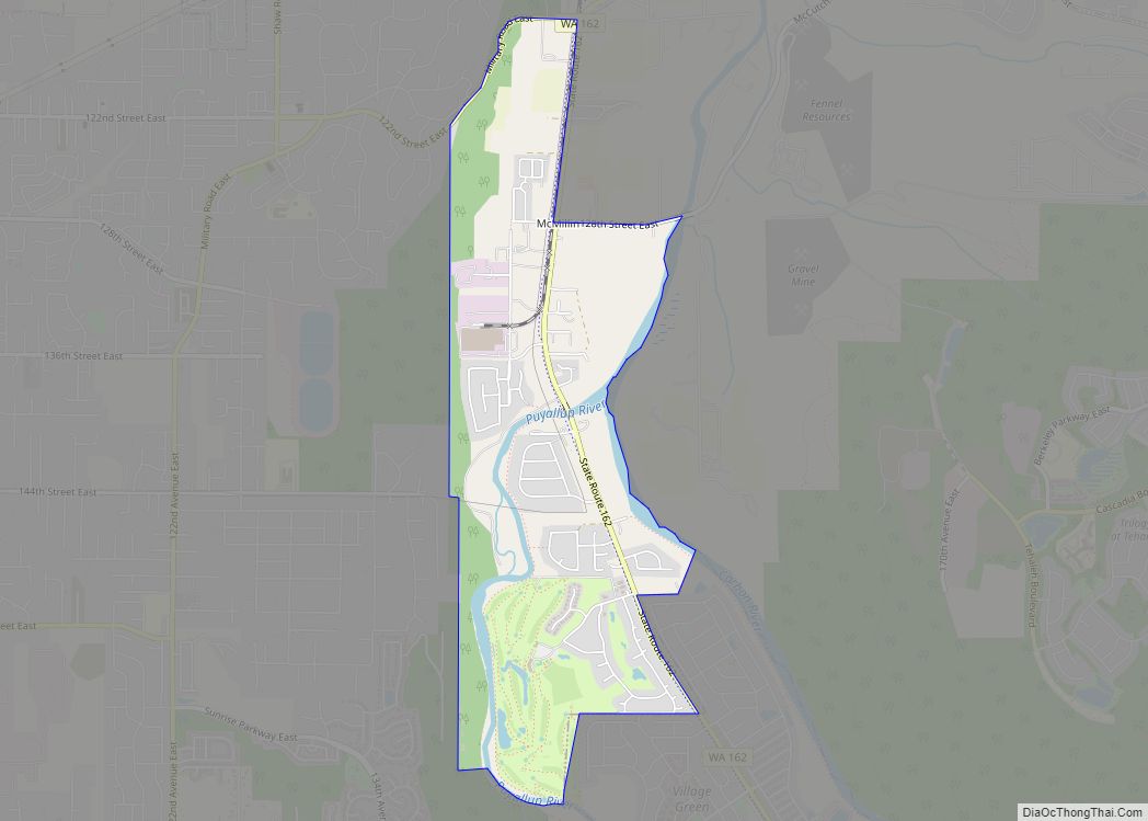
Map of Finley CDP, Washington

Map of Finley CDP, Washington

Finley is a census-designated place (CDP) in Benton County, Washington, United States. The population was 6,152 at the 2020 census. It is located to the southeast of the larger city of Kennewick. Finley CDP overview: Name: Finley CDP LSAD Code: 57 LSAD Description: CDP (suffix) State: Washington County: Benton County Elevation: 354 ft (108 m) Total Area: … Read more

Map of Fife city

Map of Fife city

Fife is a city in Pierce County, Washington, United States and a suburb of Tacoma. The population was 10,999 at the 2020 census. Fife is contained within the Puyallup Indian Reservation. Fife city overview: Name: Fife city LSAD Code: 25 LSAD Description: city (suffix) State: Washington County: Pierce County Elevation: 23 ft (7 m) Total Area: 5.89 sq mi … Read more

Map of Geneva CDP, Washington

Map of Geneva CDP, Washington

Geneva is an unincorporated area and census-designated place (CDP) in Whatcom County, Washington, United States. The population was 2,321 at the 2010 census. Based on per capita income, Geneva ranks 85th of 522 areas in the state of Washington to be ranked. It is also the highest rank achieved in Whatcom County. Geneva CDP overview: … Read more

Map of Garrett CDP, Washington

Map of Garrett CDP, Washington

Garrett is a census-designated place (CDP) in Walla Walla County, Washington, United States. The population was 1,419 at the 2010 census. Garrett CDP overview: Name: Garrett CDP LSAD Code: 57 LSAD Description: CDP (suffix) State: Washington County: Walla Walla County Elevation: 768 ft (234 m) Total Area: 2.1 sq mi (5.5 km²) Land Area: 2.1 sq mi (5.5 km²) Water Area: 0.0 sq mi (0.0 km²) … Read more

Map of Garfield town, Washington

Map of Garfield town, Washington

Garfield town overview: Name: Garfield town LSAD Code: 43 LSAD Description: town (suffix) State: Washington County: Whitman County FIPS code: 5326140 Online Interactive Map Garfield online map. Source: Basemap layers from Google Map, Open Street Map (OSM), Arcgisonline, Wmflabs. Boundary Data from Database of Global Administrative Areas. Garfield location map. Where is Garfield town? Garfield … Read more

Map of Friday Harbor town

Map of Friday Harbor town

Friday Harbor town overview: Name: Friday Harbor town LSAD Code: 43 LSAD Description: town (suffix) State: Washington County: San Juan County FIPS code: 5325615 Online Interactive Map Friday Harbor online map. Source: Basemap layers from Google Map, Open Street Map (OSM), Arcgisonline, Wmflabs. Boundary Data from Database of Global Administrative Areas. Friday Harbor location map. … Read more

Map of Freeland CDP, Washington

Map of Freeland CDP, Washington

Freeland is an unincorporated community and census-designated place (CDP) on Whidbey Island in Island County, Washington, United States. At the time of the 2010 census the population was 7,812. The town received its name based on its origins as a socialist commune in the early 1900s: in the eyes of its founders, the land of … Read more

Map of Frederickson CDP

Map of Frederickson CDP

Frederickson is a census-designated place (CDP) in Pierce County, Washington, United States. The population was 24,906 at the 2020 census. Frederickson CDP overview: Name: Frederickson CDP LSAD Code: 57 LSAD Description: CDP (suffix) State: Washington County: Pierce County Elevation: 400 ft (122 m) Total Area: 7.3 sq mi (19.0 km²) Land Area: 7.3 sq mi (18.9 km²) Water Area: 0.0 sq mi (0.1 km²) Total Population: … Read more

Map of Fox Island CDP

Map of Fox Island CDP

Fox Island is an island and census-designated place (CDP) in Pierce County, Washington, United States, in Puget Sound. It is located approximately 5 miles (8 km) from Gig Harbor. The island was named Fox by Charles Wilkes during the United States Exploring Expedition, to honor J.L. Fox, an assistant surgeon on the expedition. The population was … Read more

Map of Four Lakes CDP

Map of Four Lakes CDP

Four Lakes is an unincorporated community and census-designated place in Spokane County, Washington, United States, just southwest of the city of Spokane, and north of Cheney. As of the 2010 census, its population was 512. Both Interstate 90 and SR 904 run through Four Lakes and the junction of the two is located near the … Read more

Map of Fort Lewis CDP

Map of Fort Lewis CDP

Fort Lewis is a United States Army base located 9.1 miles (14.6 km) south-southwest of Tacoma, Washington. Fort Lewis was merged with McChord Air Force Base on 1 February 2010 to form Joint Base Lewis–McChord. Fort Lewis, named after Meriwether Lewis of the Lewis and Clark Expedition, was one of the largest and most modern military … Read more

Map of Forks city

Map of Forks city

Forks, also previously known as the unincorporated town of Quillayute, is a city in southwest Clallam County, Washington, United States. The population was 3,335 at the 2020 census. It is named after the forks in the nearby Quillayute, Bogachiel, Calawah, and Sol Duc rivers. For many years, the city’s economy was fueled by the local … Read more