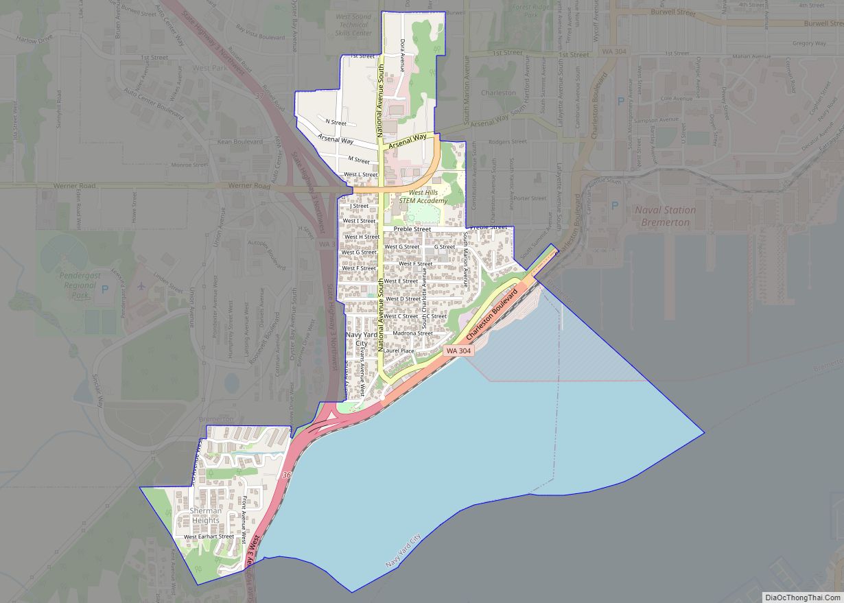
Map of Hat Island CDP

Map of Hat Island CDP

Hat Island is a census-designated place (CDP) in Snohomish County, Washington, United States. The population was 41 at the 2010 census. The CDP occupies an island in Possession Sound called Hat Island, also known as Gedney Island. The island lies in Possession Sound between the mainland city of Everett, Washington, and the southern part of … Read more

Map of Hartline town

Map of Hartline town

Hartline town overview: Name: Hartline town LSAD Code: 43 LSAD Description: town (suffix) State: Washington County: Grant County FIPS code: 5329920 Online Interactive Map Hartline online map. Source: Basemap layers from Google Map, Open Street Map (OSM), Arcgisonline, Wmflabs. Boundary Data from Database of Global Administrative Areas. Hartline location map. Where is Hartline town? Hartline … Read more

Map of Harrington city, Washington

Map of Harrington city, Washington

Harrington is a city in Lincoln County, Washington, United States. The population was 424 at the 2010 census. It was named after W.P. Harrington, a banker from Colusa, California, who had heavily invested in local land. Harrington city overview: Name: Harrington city LSAD Code: 25 LSAD Description: city (suffix) State: Washington County: Lincoln County Elevation: … Read more

Map of Harrah town, Washington

Map of Harrah town, Washington

Harrah town overview: Name: Harrah town LSAD Code: 43 LSAD Description: town (suffix) State: Washington County: Yakima County FIPS code: 5329710 Online Interactive Map Harrah online map. Source: Basemap layers from Google Map, Open Street Map (OSM), Arcgisonline, Wmflabs. Boundary Data from Database of Global Administrative Areas. Harrah location map. Where is Harrah town? Harrah … Read more

Map of Hansville CDP

Map of Hansville CDP

Hansville is an unincorporated community and census-designated place (CDP) in Kitsap County, Washington, United States. Its population was 3,858 as of the 2020 census. The coastal community is located at the northern end of the Kitsap Peninsula and is about 16 miles (26 km) northeast of Poulsbo, the nearest city. Hansville CDP overview: Name: Hansville CDP … Read more

Map of Hobart CDP, Washington

Map of Hobart CDP, Washington

Hobart is an unincorporated community and census-designated place (CDP) in King County, Washington, United States. The population was 6,767 at the 2020 census. Based on per capita income, one of the more reliable measures of affluence, Hobart ranks 31st of 522 areas in the state of Washington to be ranked. The Hobart area was first … Read more

Map of Index town

Map of Index town

Index town overview: Name: Index town LSAD Code: 43 LSAD Description: town (suffix) State: Washington County: Snohomish County FIPS code: 5333175 Online Interactive Map Index online map. Source: Basemap layers from Google Map, Open Street Map (OSM), Arcgisonline, Wmflabs. Boundary Data from Database of Global Administrative Areas. Index location map. Where is Index town? Index … Read more

Map of Inchelium CDP

Map of Inchelium CDP

Inchelium (Okanagan: N̓čaʔlíwm̓) is a census-designated place (CDP) in Ferry County, Washington, United States on the Colville Indian Reservation. The population was 431 at the 2020 Census. Inchelium was relocated from an earlier site in the early 1940s. Old Inchelium had been located on the banks of the Columbia River before the construction of the … Read more

Map of Ilwaco city

Map of Ilwaco city

Ilwaco (/ɪlˈwɑːkoʊ/ il-WAH-koh) is a city in Pacific County, Washington, United States. The population was 936 at the 2010 census. Founded in 1890, the city was home to the Ilwaco Railway and Navigation Company along the Long Beach Peninsula, with its core economy based on logging and timber rafting. The city is located on the … Read more

Map of Hunts Point town

Map of Hunts Point town

Hunts Point town overview: Name: Hunts Point town LSAD Code: 43 LSAD Description: town (suffix) State: Washington County: King County FIPS code: 5332755 Online Interactive Map Hunts Point online map. Source: Basemap layers from Google Map, Open Street Map (OSM), Arcgisonline, Wmflabs. Boundary Data from Database of Global Administrative Areas. Hunts Point location map. Where … Read more

Map of Humptulips CDP

Map of Humptulips CDP

Humptulips is a census-designated place (CDP) in Grays Harbor County, Washington, United States. The population of the CDP was 255 according to the 2010 census. Humptulips CDP overview: Name: Humptulips CDP LSAD Code: 57 LSAD Description: CDP (suffix) State: Washington County: Grays Harbor County Elevation: 161 ft (49 m) Total Area: 9.5 sq mi (24.5 km²) Land Area: 9.5 sq mi (24.5 km²) … Read more

Map of Hoquiam city

Map of Hoquiam city

Hoquiam (/ˈhoʊkwiəm/ HOH-kwee-əm) is a city in Grays Harbor County, Washington, United States. It borders the city of Aberdeen at Myrtle Street, with Hoquiam to the west. The two cities share a common economic history in lumbering and exporting, but Hoquiam has maintained its independent identity. It shares a long rivalry with its more populated … Read more