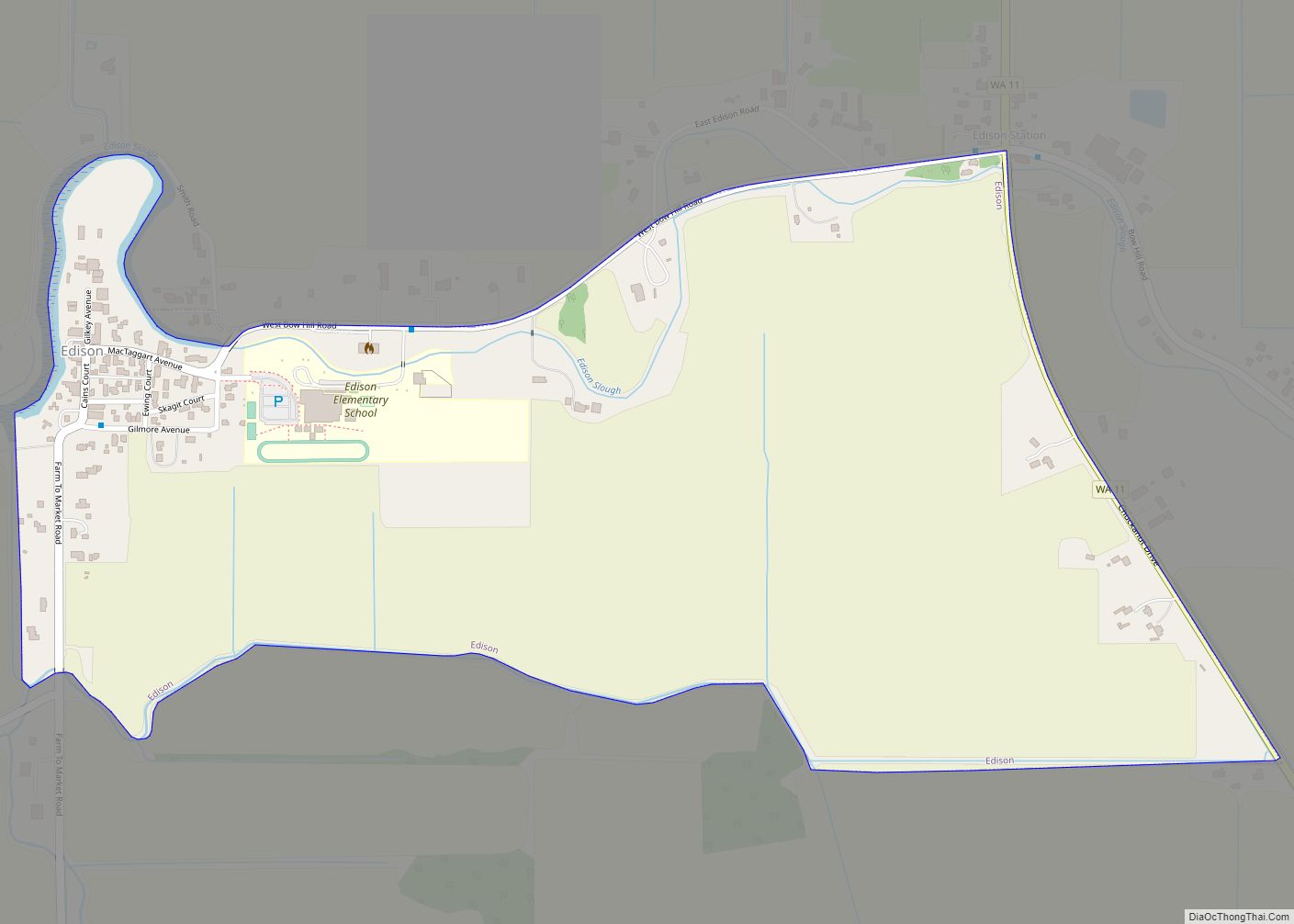
Map of Torboy CDP

Map of Torboy CDP

Torboy is a census-designated place in Ferry County, Washington, United States. Torboy CDP overview: Name: Torboy CDP LSAD Code: 57 LSAD Description: CDP (suffix) State: Washington County: Ferry County Elevation: 2,425 ft (739 m) Total Area: 0.95 sq mi (2.47 km²) Land Area: 0.93 sq mi (2.40 km²) Water Area: 0.03 sq mi (0.07 km²) Total Population: 49 Population Density: 53/sq mi (20.4/km²) Area code: 360 FIPS … Read more

Map of Suquamish CDP

Map of Suquamish CDP

Suquamish is a census-designated place (CDP) in Kitsap County, Washington, United States. The population was 4,140 at the 2010 census. Comprising the Port Madison Indian Reservation, it is the burial site of Chief Seattle and the site of the Suquamish tribe winter longhouse known as Old Man House. Suquamish CDP overview: Name: Suquamish CDP LSAD … Read more

Map of Toppenish city

Map of Toppenish city

Toppenish (/ˈtɒppənɪʃ/) is a city in Yakima County, Washington. As of the 2020 census, the city population was 8,854. It is located within the Yakama Indian Reservation, established in 1855. Toppenish calls itself the city of Murals, as it has more than 75 murals adorning its buildings. The first, “Clearing the Land”, was painted in … Read more

Map of Sunnyslope CDP

Map of Sunnyslope CDP

Sunnyslope is an unincorporated community and census-designated place (CDP) in Chelan County, Washington, United States. It is part of the Wenatchee–East Wenatchee Metropolitan Statistical Area. The population was 4,041 at the 2020 census, up from 3,252 at the 2010 census. By per capita income, Sunnyslope ranks 53rd of 522 areas in the state of Washington … Read more

Map of Tonasket city

Map of Tonasket city

Tonasket /təˈnæskət/ is a city in Okanogan County, Washington, United States. The population was 1,032 at the 2010 census. Tonasket city overview: Name: Tonasket city LSAD Code: 25 LSAD Description: city (suffix) State: Washington County: Okanogan County Elevation: 919 ft (280 m) Total Area: 0.96 sq mi (2.49 km²) Land Area: 0.94 sq mi (2.44 km²) Water Area: 0.02 sq mi (0.05 km²) Total Population: 1,032 … Read more

Map of Toledo city, Washington

Map of Toledo city, Washington

Toledo is a city in Lewis County, Washington, United States. The population was 631 at the 2020 census. Toledo city overview: Name: Toledo city LSAD Code: 25 LSAD Description: city (suffix) State: Washington County: Lewis County Elevation: 121 ft (37 m) Total Area: 0.40 sq mi (1.03 km²) Land Area: 0.39 sq mi (1.02 km²) Water Area: 0.00 sq mi (0.01 km²) Total Population: 631 Population … Read more

Map of Tokeland CDP

Map of Tokeland CDP

Tokeland is a census-designated place (CDP) in Pacific County, Washington, United States. The population was 151 at the 2010 census, a sharp decrease from the 194 at the 2000 census. The town was named after Chief Toke, an Indian chief of the 19th century. Tokeland CDP overview: Name: Tokeland CDP LSAD Code: 57 LSAD Description: … Read more

Map of Tieton city

Map of Tieton city

Tieton (/ˈtaɪ.ətən/) is a city in Yakima County, Washington, United States. The population was 1,389 at the 2020 census. In recent years, Tieton has suffered economic depression, with the decline of its fruit warehouses. As of 2007, a Seattle lawyer and the founding president of the art publishing house Marquand Books have been investing in … Read more

Map of Three Lakes CDP, Washington

Map of Three Lakes CDP, Washington

Three Lakes is a census-designated place (CDP) in Snohomish County, Washington, United States. The population was 3,184 at the 2010 census. Based on per capita income, one of the more reliable measures of affluence, Three Lakes ranks 56th of 522 areas in the state of Washington to be ranked. Three Lakes CDP overview: Name: Three … Read more

Map of Thorp CDP

Map of Thorp CDP, Washington

Thorp (/θɔːrp/ THORP) is an unincorporated community and census-designated place (CDP) in Kittitas County, Washington, United States. In 2015, the population was 317 according to statistics compiled by Data USA. The town of Thorp is 100 miles (160 km) east of Seattle, 8 miles (13 km) northwest of Ellensburg, and 17 miles (27 km) southeast of Cle Elum. … Read more

Map of Terrace Heights CDP

Map of Terrace Heights CDP

Terrace Heights is a census-designated place (CDP) in Yakima County, Washington, United States. The population was 6,937 at the 2010 census. It is essentially a suburb of the city of Yakima. Terrace Heights CDP overview: Name: Terrace Heights CDP LSAD Code: 57 LSAD Description: CDP (suffix) State: Washington County: Yakima County Elevation: 1,198 ft (365 m) Total … Read more

Map of Tenino city

Map of Tenino city

Tenino (/təˈnaɪnoʊ/) is a city in Thurston County, Washington, United States. The population was 1,870 at the 2020 census. Incorporated in 1906, the city sits upon land first established as a food-source prairie for Native Americans living in the area. The town grew around an economy of stone quarrying, with local sandstone being used in … Read more