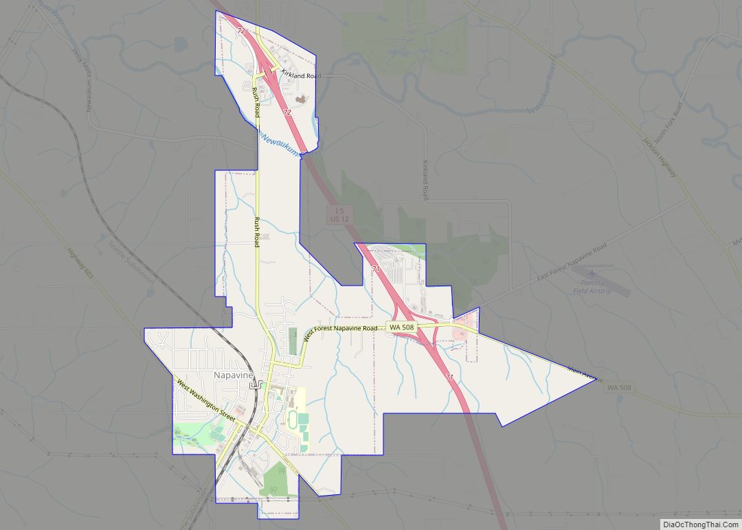
Map of Neah Bay CDP
Neah Bay is a census-designated place (CDP) on the Makah Reservation in Clallam County, Washington, United States. The population was 865 at the 2010 census. It is across the Canada–US border from British Columbia. Originally called “Scarborough Harbour” in honor of Captain James Scarborough of the Hudson’s Bay Company, it was changed to Neah in ... Read more
Map of Neah Bay CDP
Map of Nisqually Indian Community CDP
The Nisqually Reservation, also known as Nisqually Indian Reservation is a federally recognized Indian reservation in Thurston County, Washington, United States. The population was 668 at the 2020 census. Nisqually Indian Community CDP overview: Name: Nisqually Indian Community CDP LSAD Code: 57 LSAD Description: CDP (suffix) State: Washington County: Thurston County Total Area: 2.7 sq mi (7.1 km²) ... Read more
Map of Nisqually Indian Community CDP
Map of Onalaska CDP, Washington
Onalaska is an unincorporated community and census-designated place (CDP) in Lewis County, Washington, United States. As of the 2020 census it had a population of 657. Onalaska is located along Washington State Route 508. Onalaska CDP overview: Name: Onalaska CDP LSAD Code: 57 LSAD Description: CDP (suffix) State: Washington County: Lewis County Elevation: 515 ft (157 m) ... Read more
Map of Onalaska CDP, Washington
Map of Ocean Park CDP
Ocean Park is a census-designated place (CDP) in Pacific County, Washington, United States. The population was 1,573 at the 2010 census. It is on the Long Beach Peninsula, north of Long Beach, Washington. Ocean Park CDP overview: Name: Ocean Park CDP LSAD Code: 57 LSAD Description: CDP (suffix) State: Washington County: Pacific County Elevation: 39 ft ... Read more
Map of Ocean Park CDP
Map of Northport town, Washington
Northport town overview: Name: Northport town LSAD Code: 43 LSAD Description: town (suffix) State: Washington County: Stevens County FIPS code: 5350045 Online Interactive Map Northport online map. Source: Basemap layers from Google Map, Open Street Map (OSM), Arcgisonline, Wmflabs. Boundary Data from Database of Global Administrative Areas. Northport location map. Where is Northport town? Northport ... Read more
Map of Northport town, Washington
Map of North Yelm CDP
North Yelm is a census-designated place (CDP) in Thurston County, Washington, United States. The population was 3,140 at the 2020 census. The community borders Yelm and is situated near the intersection of Washington State Route 507 and SR 510. North Yelm CDP overview: Name: North Yelm CDP LSAD Code: 57 LSAD Description: CDP (suffix) State: ... Read more
Map of North Yelm CDP
Map of Packwood CDP, Washington
Packwood is an unincorporated community and census-designated place (CDP) located in easternmost Lewis County, Washington, in the United States. As of the 2020 census, the CDP had a population of 319, while the town and surrounding Packwood community (east of Cora Bridge) had a total population of 1,277. Packwood was originally established as Sulphur Springs. ... Read more
Map of Packwood CDP, Washington
Map of Port Angeles city
Port Angeles (/ˈændʒələs/ AN-jəl-əs) is a city and county seat of Clallam County, Washington, United States. With a population of 19,960 as of the 2020 census, it is the largest city in the county. The population was estimated at 20,134 in 2021. The city’s harbor was dubbed Puerto de Nuestra Señora de los Ángeles (Port ... Read more
Map of Port Angeles city
Map of Port Angeles East CDP
Port Angeles East is a census-designated place (CDP) in Clallam County, Washington, United States. The population was 3,036 at the 2010 census. This unincorporated urban growth area bordering the city of Port Angeles is known by locals as the Gales Addition. Port Angeles East CDP overview: Name: Port Angeles East CDP LSAD Code: 57 LSAD ... Read more
Map of Port Angeles East CDP
Map of Rainier city, Washington
Rainier (/reɪˈnɪər/ ray-NEER) is a city in Thurston County, Washington, United States. Beginning as a train stop in the 1870s, Rainier was first settled in 1890 and would become known as a logging town. The city was officially incorporated in 1947. Rainier city overview: Name: Rainier city LSAD Code: 25 LSAD Description: city (suffix) State: ... Read more
Map of Rainier city, Washington
Map of Rock Island city, Washington
Rock Island is a city in Douglas County, Washington, United States. It is part of the Wenatchee–East Wenatchee Metropolitan Statistical Area. The population was 788 at the 2010 census. Rock Island city overview: Name: Rock Island city LSAD Code: 25 LSAD Description: city (suffix) State: Washington County: Douglas County Elevation: 643 ft (196 m) Total Area: 1.40 sq mi ... Read more
Map of Rock Island city, Washington
Map of Roosevelt CDP, Washington
Roosevelt is an unincorporated community and census-designated place (CDP) in Klickitat County, Washington, United States. The population was 156 at the 2010 census, up from 79 at the 2000 census. The Roosevelt Regional Landfill, one of the largest landfills in the United States, is located at Roosevelt. The community was named after President Theodore Roosevelt. ... Read more
Map of Roosevelt CDP, Washington