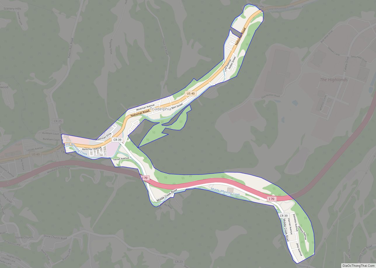
Map of War city
War is a city in McDowell County, West Virginia, United States. The population was 690 at the 2020 census. War was incorporated in 1920 by the Circuit Court of McDowell County. Its name is derived from War Creek, whose confluence with Dry Fork is located within the city. War is the only place in the ... Read more
Map of War city
Map of Thomas city, West Virginia
Thomas is a city and former coal town in Tucker County, West Virginia, United States. The population was 623 at the 2020 census. Thomas city overview: Name: Thomas city LSAD Code: 25 LSAD Description: city (suffix) State: West Virginia County: Tucker County Elevation: 3,035 ft (925 m) Total Area: 4.51 sq mi (11.67 km²) Land Area: 4.46 sq mi (11.55 km²) Water Area: ... Read more
Map of Thomas city, West Virginia
Map of Wallace CDP, West Virginia
Wallace CDP overview: Name: Wallace CDP LSAD Code: 57 LSAD Description: CDP (suffix) State: West Virginia FIPS code: 5484172 Online Interactive Map Wallace online map. Source: Basemap layers from Google Map, Open Street Map (OSM), Arcgisonline, Wmflabs. Boundary Data from Database of Global Administrative Areas. Wallace location map. Where is Wallace CDP? Wallace Road Map ... Read more
Map of Wallace CDP, West Virginia
Map of Terra Alta town
Terra Alta is a town in eastern Preston County, West Virginia, United States. The population was 1,415 at the 2020 census. It is part of the Morgantown metropolitan area. Terra Alta town overview: Name: Terra Alta town LSAD Code: 43 LSAD Description: town (suffix) State: West Virginia County: Preston County Elevation: 2,582 ft (787 m) Total Area: ... Read more
Map of Terra Alta town
Map of Vivian CDP, West Virginia
Vivian is a census-designated place (CDP) in McDowell County, West Virginia, United States. Vivian is located along U.S. Route 52, 1 mile (1.6 km) southeast of Kimball. As of the 2010 census, its population was 82. An old variant name was Clausen. The Peerless Coal Company Store was listed on the National Register of Historic Places ... Read more
Map of Vivian CDP, West Virginia
Map of Verdunville CDP
Verdunville is an unincorporated community and census-designated place (CDP) in Logan County, West Virginia, United States. It is 3.5 miles (5.6 km) west of Logan, the county seat. Verdunville has a post office with ZIP code 25649. The Verdunville CDP includes the neighboring community of Shegon. As of the 2010 census, the total CDP population was ... Read more
Map of Verdunville CDP
Map of Van CDP, West Virginia
Van is a census-designated place (CDP) in Boone County, West Virginia, United States, along the Pond Fork of the Little Coal River. As of the 2010 census, its population was 211. Its ZIP code is 25206. Van was named after Van Linville, who established its post office and served as its first postmaster. Van CDP ... Read more
Map of Van CDP, West Virginia
Map of Valley Head CDP, West Virginia
Valley Head is a census-designated place (CDP) in Randolph County, West Virginia, United States. Valley Head is located on U.S. Route 219, 12 miles (19 km) south-southwest of Huttonsville. Valley Head has a post office with ZIP code 26294. As of the 2010 census, its population was 267. The community was named for the nearby headwaters ... Read more
Map of Valley Head CDP, West Virginia
Map of Valley Bend CDP
Valley Bend is a census-designated place (CDP) in Randolph County, West Virginia, United States. Valley Bend is located on U.S. routes 219 and 250, as well as state routes 55 and 92, 3.5 miles (5.6 km) northwest of Mill Creek. Valley Bend has a post office with ZIP code 26293. As of the 2010 census, its ... Read more
Map of Valley Bend CDP
Map of Union town, West Virginia
Union is a town in Monroe County, West Virginia, United States. Union’s population is 427 as of 2020. It is the county seat of Monroe County. Union town overview: Name: Union town LSAD Code: 43 LSAD Description: town (suffix) State: West Virginia County: Monroe County Elevation: 2,073 ft (632 m) Total Area: 0.45 sq mi (1.16 km²) Land Area: 0.45 sq mi ... Read more
Map of Union town, West Virginia
Map of Twilight CDP, West Virginia
Twilight is a census-designated place (CDP) in Boone County, West Virginia, United States. As of the 2010 census, its population was 90. Twilight is approximately 20 miles from Madison. Twilight is accessible from Boone County Route 26, which is located right off West Virginia Route 85 at the Van Bridge split. The name Twilight was ... Read more
Map of Twilight CDP, West Virginia
Map of Tunnelton town
Tunnelton is a town in southwestern Preston County, West Virginia, United States. The population was 307 at the 2020 census. It is part of the Morgantown metropolitan area. Tunnelton town overview: Name: Tunnelton town LSAD Code: 43 LSAD Description: town (suffix) State: West Virginia County: Preston County Elevation: 1,824 ft (556 m) Total Area: 0.34 sq mi (0.87 km²) Land ... Read more
Map of Tunnelton town