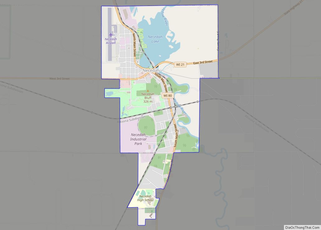
Map of Franklin city, Wisconsin

Map of Franklin city, Wisconsin

Franklin is a city in Milwaukee County, Wisconsin, United States. It is a suburb of Milwaukee with a population of 36,816 as of the 2020 census. Franklin city overview: Name: Franklin city LSAD Code: 25 LSAD Description: city (suffix) State: Wisconsin County: Milwaukee County Founded: 1841 Incorporated: 1956 Elevation: 790 ft (241 m) Total Area: 34.68 sq mi (89.82 km²) … Read more

Map of Gilman village, Wisconsin

Map of Gilman village, Wisconsin

Gilman is a village in Taylor County, Wisconsin, United States. The population was 410 at the 2010 census. The village is located between the towns of Aurora and Ford. Gilman village overview: Name: Gilman village LSAD Code: 47 LSAD Description: village (suffix) State: Wisconsin County: Taylor County Elevation: 1,224 ft (373 m) Total Area: 2.34 sq mi (6.06 km²) Land … Read more

Map of Francis Creek village

Map of Francis Creek village

Francis Creek is a village in Manitowoc County, Wisconsin, United States. The population was 659 at the 2020 census. The village is located within the town of Kossuth. Francis Creek village overview: Name: Francis Creek village LSAD Code: 47 LSAD Description: village (suffix) State: Wisconsin County: Manitowoc County Elevation: 732 ft (223 m) Total Area: 1.14 sq mi (2.94 km²) … Read more

Map of Gillett city, Wisconsin

Map of Gillett city, Wisconsin

Gillett is a city in Oconto County, Wisconsin, United States. The population was 1,386 at the 2010 census. It is part of the Green Bay Metropolitan Statistical Area. The city is adjacent to the Town of Gillett. Gillett city overview: Name: Gillett city LSAD Code: 25 LSAD Description: city (suffix) State: Wisconsin County: Oconto County … Read more

Map of Fox Point village

Map of Fox Point village

Fox Point is a village in Milwaukee County, Wisconsin, United States. The population was 6,934 at the 2020 census. Located on the western shore of Lake Michigan, Fox Point is one of the North Shore suburbs of the Milwaukee metropolitan area. The village is primarily residential. Shopping centers include Fox Point Shops, and RiverPoint Shopping … Read more

Map of Granton village

Map of Granton village

Granton is a village in Clark County in the U.S. state of Wisconsin. The population was 355 at the 2010 census. Granton village overview: Name: Granton village LSAD Code: 47 LSAD Description: village (suffix) State: Wisconsin County: Clark County Elevation: 1,119 ft (341 m) Total Area: 0.55 sq mi (1.42 km²) Land Area: 0.55 sq mi (1.41 km²) Water Area: 0.00 sq mi (0.01 km²) Total … Read more

Map of Grand View CDP, Wisconsin

Map of Grand View CDP, Wisconsin

Grand View (also Grandview, Pratt) is an unincorporated, census-designated place located in the town of Grandview, Bayfield County, Wisconsin, United States. U.S. Highway 63 serves as a main route in the community. Grand View is located 23 miles southwest of the city of Ashland; and 34 miles northeast of the city of Hayward. Grand View … Read more

Map of Grand Marsh CDP

Map of Grand Marsh CDP

Grand Marsh is an unincorporated census-designated place located in Adams County, Wisconsin, United States. The community is southeast of Adams, in the town of New Chester. Grand Marsh has a post office with ZIP code 53936, which opened in 1850. As of the 2010 census, its population is 127. The community took its name from … Read more

Map of Grafton village, Wisconsin

Map of Grafton village, Wisconsin

The Town of Grafton is a town located in Ozaukee County, Wisconsin, United States, and is in the Milwaukee metropolitan area. The town was created in 1846 and at the time of the 2020 Census had a population of 4,157. Grafton is located on the western shore of Lake Michigan. German and Irish immigrants first … Read more

Map of Gotham CDP

Map of Gotham CDP

Gotham (also Richland City) is a census-designated place, in the town of Buena Vista, in Richland County, Wisconsin, United States. It is located at the intersection of Wisconsin Highway 60 and U.S. Route 14. It is just north of the Wisconsin River, northeast of Avoca and southeast of Richland Center. As of the 2020 census, … Read more

Map of Gordon CDP, Wisconsin

Map of Gordon CDP, Wisconsin

Gordon is an unincorporated, census-designated place; located in the town of Gordon, Douglas County, Wisconsin, United States. Gordon CDP overview: Name: Gordon CDP LSAD Code: 57 LSAD Description: CDP (suffix) State: Wisconsin County: Douglas County Elevation: 1,033 ft (315 m) Total Area: 1.856 sq mi (4.81 km²) Land Area: 1.835 sq mi (4.75 km²) Water Area: 0.021 sq mi (0.05 km²) Total Population: 176 Population Density: … Read more

Map of Goodman CDP, Wisconsin

Map of Goodman CDP, Wisconsin

Goodman is an unincorporated census-designated place located in the town of Goodman, Marinette County, Wisconsin, United States. Goodman is located on U.S. Route 8 19.5 miles (31.4 km) west-southwest of Niagara. Goodman has a post office with ZIP code 54125. As of the 2010 census, its population is 271. Goodman CDP overview: Name: Goodman CDP LSAD … Read more