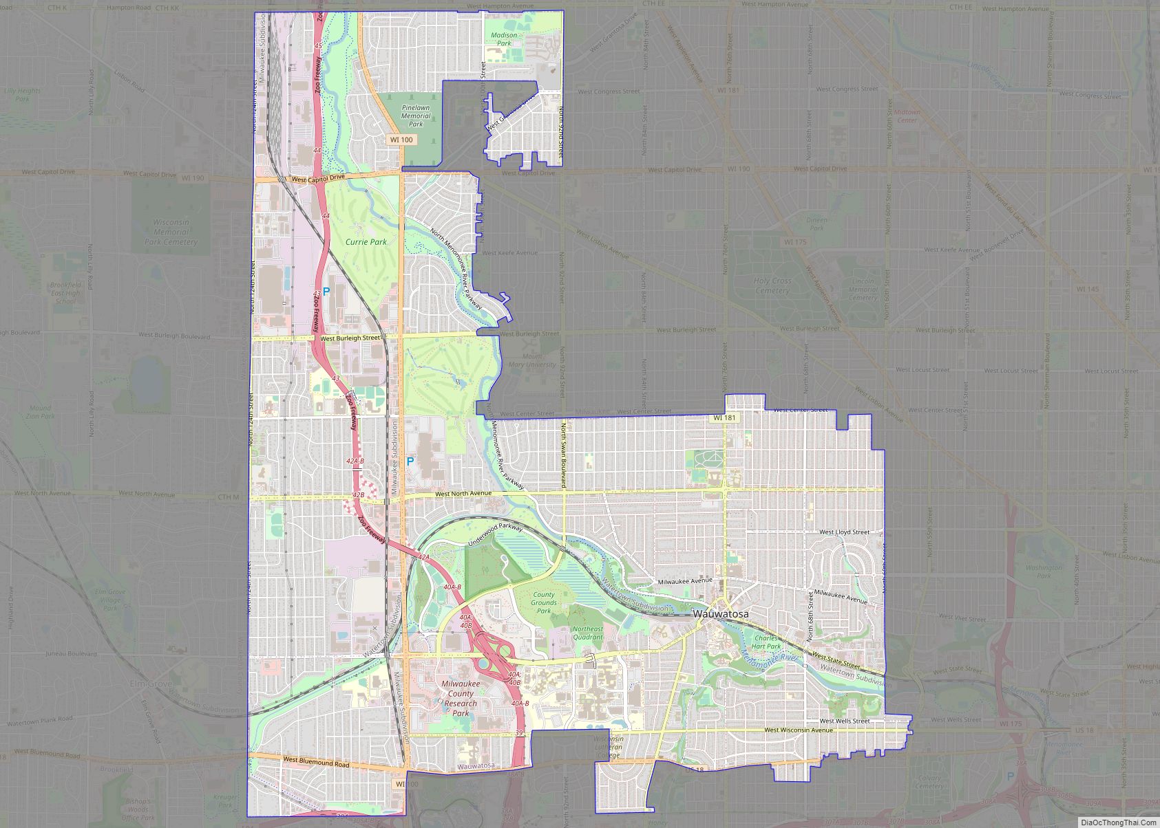
Map of Watertown city, Wisconsin
Watertown is a city in Dodge and Jefferson counties in the U.S. state of Wisconsin. Most of the city’s population is in Jefferson County. Division Street, several blocks north of downtown, marks the county line. The population of Watertown was 22,926 at the 2020 census. Of this, 14,674 were in Jefferson County, and 8,252 were ... Read more
Map of Watertown city, Wisconsin
Map of Waterloo city, Wisconsin
Waterloo is a city in Jefferson County in the U.S. state of Wisconsin. As of the census of 2020, the population was 3,483. The name Waterloo was suggested by Mr. Wilt, a Frenchman living here, who was one of Napoleon’s soldiers, at the battle of Waterloo. Waterloo is located in the Watertown-Fort Atkinson micropolitan area ... Read more
Map of Waterloo city, Wisconsin
Map of Whitewater city, Wisconsin
Whitewater is a city located in Walworth and Jefferson counties in the U.S. state of Wisconsin. Located near the southern portion of the Kettle Moraine State Forest, Whitewater is the home of the University of Wisconsin–Whitewater. As of the 2020 census, the city’s population was 14,889. Whitewater city overview: Name: Whitewater city LSAD Code: 25 ... Read more
Map of Whitewater city, Wisconsin
Map of West Allis city
West Allis is a city in Milwaukee County, Wisconsin, United States. A suburb of Milwaukee, it is part of the Milwaukee metropolitan area. The population was 60,325 at the 2020 census. West Allis city overview: Name: West Allis city LSAD Code: 25 LSAD Description: city (suffix) State: Wisconsin County: Milwaukee County Elevation: 728 ft (222 m) Total ... Read more
Map of West Allis city
Map of Whitehall city, Wisconsin
Whitehall is a city in Trempealeau County, Wisconsin, United States, along the Trempealeau River. The population was 1,645 at the 2020 census. It is the county seat of Trempealeau County. Whitehall is situated on the former Green Bay and Western Railroad midway between La Crosse and Eau Claire. Whitehall city overview: Name: Whitehall city LSAD ... Read more
Map of Whitehall city, Wisconsin
Map of Whitefish Bay village
Whitefish Bay is a village in Milwaukee County, Wisconsin, United States. The population was 14,954 at the 2020 census. Whitefish Bay village overview: Name: Whitefish Bay village LSAD Code: 47 LSAD Description: village (suffix) State: Wisconsin County: Milwaukee County Elevation: 650 ft (198 m) Total Area: 2.12 sq mi (5.48 km²) Land Area: 2.12 sq mi (5.48 km²) Water Area: 0.00 sq mi (0.00 km²) Total ... Read more
Map of Whitefish Bay village
Map of White Lake village, Wisconsin
White Lake is a village in Langlade County, Wisconsin, United States. The population was 363 at the 2010 census. The White Lake Volunteer Fire Department is located within the village. White Lake village overview: Name: White Lake village LSAD Code: 47 LSAD Description: village (suffix) State: Wisconsin County: Langlade County Elevation: 1,286 ft (391.9728 m) Total Area: ... Read more
Map of White Lake village, Wisconsin
Map of Wheeler village, Wisconsin
Wheeler is a village in Dunn County, Wisconsin, United States, along the Hay River. The population was 348 at the 2010 census. Wheeler village overview: Name: Wheeler village LSAD Code: 47 LSAD Description: village (suffix) State: Wisconsin County: Dunn County Elevation: 942 ft (287 m) Total Area: 0.87 sq mi (2.25 km²) Land Area: 0.82 sq mi (2.13 km²) Water Area: 0.05 sq mi (0.12 km²) ... Read more
Map of Wheeler village, Wisconsin
Map of Weyerhaeuser village
Weyerhaeuser is a village in Rusk County, Wisconsin, United States. The population was 238 at the 2010 census. Weyerhaeuser village overview: Name: Weyerhaeuser village LSAD Code: 47 LSAD Description: village (suffix) State: Wisconsin County: Rusk County Elevation: 1,188 ft (362 m) Total Area: 0.95 sq mi (2.45 km²) Land Area: 0.94 sq mi (2.42 km²) Water Area: 0.01 sq mi (0.03 km²) Total Population: 238 Population ... Read more
Map of Weyerhaeuser village
Map of Weyauwega city
Weyauwega is a city in Waupaca County, Wisconsin, United States. The population was 1,900 at the 2010 census. The city is located mostly within the Town of Weyauwega, though it is politically independent of the town. Small portions extend north into the adjacent Town of Royalton. The city is commonly referred to as “Wega” by ... Read more
Map of Weyauwega city
Map of Weston village, Wisconsin
Weston is a village in Marathon County, Wisconsin. It is part of the Wausau Metropolitan Statistical Area. The population was 14,868 at the time of the 2010 census. Weston village overview: Name: Weston village LSAD Code: 47 LSAD Description: village (suffix) State: Wisconsin County: Marathon County Elevation: 1,250 ft (381 m) Total Area: 21.64 sq mi (56.05 km²) Land Area: ... Read more
Map of Weston village, Wisconsin
Map of Westfield village, Wisconsin
Westfield is a village in Marquette County, Wisconsin, United States. The population was 1,254 at the 2010 census. The village is located mostly within the Town of Westfield. A small portion extends east into the adjacent Town of Harris. The Marquette County fairgrounds is located within the village limits on the south side. Westfield village ... Read more
Map of Westfield village, Wisconsin